Sold2018Antique Hand Colored Maps of Dutchess County, NY.Antique Hand Colored Maps of Dutchess County, NY. This lot includes three 19th century hand colored maps from the "Atlas of New York and Vicinity" by F.W. Beers. Includes one map of Hyde Park, one mapSee Sold Price
Sold2017Three framed local maps including Dutchess County NY,Three framed local maps including Dutchess County NY, Putnam County NY, and a hand colored City of Poughkeepsie. All in good condition, late 19th to early 20th century.See Sold Price
Sold2018Antique Hand Colored Maps of Fairfield County CTAntique Hand Colored Maps of Fairfield County CT. This lot includes three 19th century hand colored maps from the "Atlas of Fairfield County CT" by F.W. Beers. Includes one map of Bethel, one map of DSee Sold Price
Sold2018Antique Hand Colored Maps of Westchester County NYAntique Hand Colored Maps of Westchester County NY. This lot includes three 19th century hand colored maps from the "Atlas of Westchester County, NY" by G.W. Bromley & Co. Includes one map of the VillSee Sold Price
Sold2018Antique Hand Colored Maps of Westchester County NYAntique Hand Colored Maps of Westchester County NY. This lot includes three 19th century hand colored maps from the "Atlas of Westchester County NY" by G.W. Bromley and Co. Includes one map of HastingSee Sold Price
Sold2018Antique Hand Colored Maps of Westchester County NYAntique Hand Colored Maps of Westchester County NY. This lot includes three 19th century hand colored maps from the "Atlas of Westchester County, NY" by G.W. Bromley & Co. Includes one map of Pelham,See Sold Price
Sold2018LARGE ANTIQUE HAND COLORED MAP JEFFERSON COUNTY NYLarge antique hand colored map of Jefferson County, New York. Circa 1855. Framed in large wooden frame and laid down to canvas backing. Condition: mounted/laid on canvas for preservation, some areas rSee Sold Price
Sold2018Antique Hand Colored Maps of Westchester County NYAntique Hand Colored Maps of Westchester County NY. This lot includes three 19th century hand colored maps including two from F.W. Beers "Atlas of New York and Vicinity" and one unmarked. Includes oneSee Sold Price
Sold2019COLTON, George Woolworth (1827-1901). Map of theCOLTON, George Woolworth (1827-1901). Map of the Country Thirty Three Miles Around the City of New York. New York: J. H. Colton, 1846 [i.e., 1865]. Hand-colored lithographed map, visible area 23 3/4 bSee Sold Price
Sold2018Two hand colored two part maps of Rockefellerland toTwo hand colored two part maps of Rockefellerland to include Pocantico Hills New York, Westchester County and Area for Early Action. 45" x 39 1/2" each Provenance: Estate of Peggy & David RockefellerSee Sold Price
Sold2023Samuel Augustus Mitchell 'County Map of...GA and AL'A Samuel Augustus Mitchell (American, 1792-1868) hand colored engraving titled 'County Map of the States of Georgia and Alabama' depicting the tri-state area of Georgia, Alabama and part of Florida anSee Sold Price
Sold2019Three Maps by Samuel Augustus Mitchell (1790-1868),Three Maps by Samuel Augustus Mitchell (1790-1868), "County Map of England and Wales," 1860, hand colored, H.-15 3/8 in., W.- 12 1/8 in. (3 Pcs.)See Sold Price
Sold2019Three Maps by Samuel Augustus Mitchell (1790-1868), "Three Maps by Samuel Augustus Mitchell (1790-1868), " County Maps of Arkansas, Louisiana and Mississippi, Verso with Florida, and a Plan of New Orleans" 1882, hand colored, on two pages, H.-24 in., W.See Sold Price
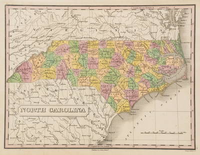
Sold2023Anthony Finley North Carolina Counties MapA Anthony Finley (American, 1784-1834) handcolored engraving depicting the counties within North Carolina and the surrounding areas. Stamped 'Published By A. Finley Phliad.' lower center. Presented inSee Sold Price
Sold2020Scarce pocket map of Missouri, 1855Title: Scarce pocket map of Missouri, 1855 Description: Beautiful and scarce pocket map of Missouri, published 1855 by J. H. Colton. Hand-colored by county. Toning where glued into pocket. Three tinySee Sold Price
Sold2022THREE HAND-COLORED MAPSTHREE HAND-COLORED MAPS1) “Insulae Indiae Orientalis” from the Mercator/Hondius Atlas Minor, Mid-16th Century. 6” x 7.75” sight. Framed 12.25” x 14.25”.2) "DeSee Sold Price
Sold2022THREE HAND-COLORED MAPS OF ASIATHREE HAND-COLORED MAPS OF ASIA1) “Asia”, from a miniature Ortelius atlas, Brescia, after 1598. 3.75” x 5” sight. Framed 9” x 10.5”.2) “A New Map of Asia̶See Sold Price
Sold2022THREE HAND-COLORED MAPS AND A MINIATURE MAP OF ESSEXTHREE HAND-COLORED MAPS AND A MINIATURE MAP OF ESSEXHand-colored maps:1) “Espagne et Portugal”, Frs. Delamarche, 1817. 12” x 16” sight. Framed 19.75” x 23.5”.2) â�See Sold Price
Sold2019Two Maps by Abraham Ortelius (1527-1598), "PeruviaeTwo Maps by Abraham Ortelius (1527-1598), "Peruviae Auriferae Regionis Typus, La Florida Aue Torre Hieron Chiaues, Guastecan Reg," each containing three hand colored maps on two sheets, 1595, hand colSee Sold Price
Sold2022MAPS: John Speed (England, 1552-1629), threeMAPS: John Speed (England, 1552-1629), three hand-colored maps on paper: one a map of Suffolk with town plan of Ipswich, dated 1610 in block, described and divided into hundreds, inset plan of IpswichSee Sold Price
Sold2021Three Antique Hand Colored MapsA grouping of three antique hand-colored engraved maps to include a 1642 map of America, a 1794 Laurie and Whittle plan of a Puerto Cavello, and a Laurie and Whittle plan of the Road and Town of La GuSee Sold Price
Sold2021Blaeu Antique Maps of Spain (18th Century) (three)Three hand-colored engraved maps, sheets 20 x 24” to 18 x 22 ½”, all with center folds as issued. (3)See Sold Price
Sold2023Antique Hand Colored Maps of Westchester County NYAntique Hand Colored Maps of Westchester County NY. This lot includes four 19th century hand colored maps from the "Atlas of New York and Vicinity" by F.W. Beers. Includes one map of Bedford, one mapSee Sold Price
Sold2018Antique Hand Colored Maps of Westchester County NYAntique Hand Colored Maps of Westchester County NY. This lot includes four 19th century hand colored maps from the "Atlas of New York and Vicinity" by F.W. Beers. Includes one map of Mamaroneck/Rye NeSee Sold Price
Jun 08Early American History Auctions1836 Hand-Colored Map, Country Twenty Five Miles Round The City Of New-York Published by D.S. Stone$260
Jun 08Early American History Auctions1776 Map, PARTIE ORIENTALE DU CANADA, AVEC LA NOUVELLE ANGLETERRE, L'ACADIE... by P. Santini, Framed$950
Jun 14DuMouchellesWilliam Barker (American, 1770-1805) And Various Engravers Hand Colored Engraved Maps Ca. 18th/19th$50
Jun 08Early American History Auctions1753 Map of the County of Lancaster Divided into its Hundreds, by Royal Mapmaker Emanuel Bowen$280
1 day LeftTrillium Antique Prints & Rare BooksJohn James Audubon's Birds of America - 7 Volume set with 500 Originally Hand-colored Lithographs,$30,000


![COLTON, George Woolworth (1827-1901). Map of the: COLTON, George Woolworth (1827-1901). Map of the Country Thirty Three Miles Around the City of New York. New York: J. H. Colton, 1846 [i.e., 1865]. Hand-colored lithographed map, visible area 23 3/4 b](https://p1.liveauctioneers.com/197/151909/76680338_1_x.jpg?height=310&quality=70&version=1570472488)