Sold2018Antique Wall Map NEW YORK POSTAL ROUTES 1898 MailDetails: This large hanging wall map of postal routes in the state of New York was created by topographer A. von Haake, and printed by "Julius Bien & Co., Photo. Lith." Dated March, 1, 1898, this mapSee Sold Price
Sold2022(NEW YORK.) John Homer French. The State of New York from New and Original Surveys.(NEW YORK.) John Homer French. The State of New York from New and Original Surveys. Large hand-colored engraved wall map of New York with many inset views and detail maps. 4 sheets joined, 68x73 incheSee Sold Price
Sold2023US WALL MAPS AND AERIAL VIEW OF NEW YORK CITYA lot of three antique and vintage wall maps of New York. The lot includes a 1914 map of New York bay and harbor, a D. Lambert Railing Co. color map of New York State, and an aerial view of Hudson RivSee Sold Price
Sold2019LARGE WALL MAP ULSTER COUNTY NEW YORKLARGE WALL MAP ULSTER COUNTY NEW YORK-OLIVER TILLSON, C. 1853 44" X 54"See Sold Price
Sold2016Wall Map Rockland County New York, 1854WALL MAP ROCKLAND COUNTY NEW YORK, 1854 Surveyed and Published by R.F.O' Connor, New York Dimension: 46.6" x 34" Condition: Good , no stains or repairs. General handling wear. Provenance: Private EstaSee Sold Price
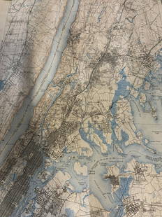
Sold20231910 National Map Company Wall Map State Of New York1910 roll down wall map printed by the National Map Company showing the counties, towns, roads, steamships routes etc within the State Of New York. The map which measures approximately 44" by 64" togeSee Sold Price
Sold2023Early Wall Map of Dutchess Putnam New York, David Burr 1839Early Wall Map of Dutchessand Putnam County New York, David Burr 1839. Antique map in scroll format with thick dark painted wood supports features cities of the period including Poughkeepsie, RhinebecSee Sold Price
Sold2021Antique 1858 Wall Map of Columbia County,NY New YorkLarge antique c.1858 map of Columbia county New York. This large map has lots of great details. It is perfect for anyone interested in local Hudson Valley history. The dimensions are 57in x 66in x 1.5See Sold Price
Sold2022HYDE & CO. WESTCHESTER COUNTY WALL MAP 1900"Map of the Greater Portion of Westchester County including Greenwich and Stamford, CT and the Upper Part of New York City." Wall map on linen with hand-colored outlines plus editions of plan of VillaSee Sold Price
Sold2022Antique Wall Map of Middle EastColton's One Sheet Map of the Lands Mentioned in the Bible. Colton, Ohman & Co., New York: 1885. Wall map on cloth. Eastern Europe, Turkey, Holy Land, Israel. 25 1/2" x 37".See Sold Price
Sold2020Vintage New York City Subway Wall MapVintage New York City Subway wall map. 41" x 26".See Sold Price
Sold2018Rollup wall map entitled "Map of Ulster Country NewRollup wall map entitled "Map of Ulster Country New York" from original surveys by Oliver J. Tillson & P. Henry Brink - dated 1853. 4' 6"W x 3' 5"H. Lithographed paper applied to canvas. Slight frayinSee Sold Price
Sold2022New York City Subway Metal Wall Mapmeasures about 11 1/2 inches by 17 1/2 inches; with originbal cellophaneSee Sold Price
Sold20231842 MATHER & SMITH WALL MAP OF LONG ISLAND, NYHand-colored lithograph. "A Geological Map of Long & Staten Islands with the Environs of New York"; William W. Mather, geologist and J. Calvin Smith, surveyor. This landmark pre-Civil War map is the eSee Sold Price
Sold20231902 National Publishing Company Wall Map1902 roll down wall map printed by the National Publishing Company New Railroad, Post office, Township, and County Map of New York which measures approximately 48" by 41". Condition - fine.See Sold Price
Sold2021Antique 1858 Wall Map,Dutchess County,NY Rhinebeck,EtcAntique 1858 Wall Map,Dutchess County,NY Rhinebeck,Etc. This Large detailed antique map of Dutchess county New York is dated 1858. This large map has lots of great little details including drawings anSee Sold Price
Sold2019Framed Map Of North Castle New YorkFramed Map Of North Castle New York. Framed in black toned frame and cream / brown double mat. Not examined out of frame. Some spots on map. Wall art, home decor, home accessory. Measures approx 24 inSee Sold Price
Sold2019Stony's Map of Twelve Miles Around New York CityAntique map, published by Newark Library, 1840, to be hung on a wall, on antique dowels. [Map: 38 x 38 inches]. In fair condition; partially detached from dowels.See Sold Price
Sold2018Hand Colored Antique Map Of New Amsterdam (New York)Map of the Original Grants of Village Lots from the Dutch West India Company to the inhabitant of New-Amsterdam, (now New-York) living below the present line of Wall Street. 19 1/2 x 17 in. (Framed),See Sold Price
Sold2021Large Antique Hanging Map of Columbia County NY 1858Large Antique Hanging Map of Columbia County New York from 1858. Shows details and insets of towns and villages in Columbia county. Has a top piece made to hang on the wall. Has a beautiful patina andSee Sold Price
Sold2023Group lot of NEW YORK State Topographical MapsGroup lot of NEW YORK State Topographical Maps, maps measure 17 x 21 inches, wear consistent with age and use. not framed. Art, wall art, artwork, home decor, maps, topographic, topography, New York SSee Sold Price
Sold2022Group lot of NEW YORK State Topographical MapsGroup lot of NEW YORK State Topographical Maps, maps measure 17 x 21 inches, wear consistent with age and use. not framed. Art, wall art, artwork, home decor, maps, topographic, topography, New York SSee Sold Price
Sold2021Dolph & Stewart 30s Map Columbia County NY Large FolioMap of Columbia County with Eastern part of Greene County, New York, by Dolph & Stewart, circa 1930s. This is a oversized hardcover bound version of what would be tiles from a large wall-mounted mSee Sold Price
Sold2023Wilson, History of Napoleonic Wars 1st US Edition 1817, Map"A Sketch of the Military and Political Power of Russia in the Year 1817", (anonym) by Robert Thomas Wilson, published by Kirk and Mercein, Wall-Street, New York, in 1817. The fold-out map of Russia iSee Sold Price
23 hrs LeftGold Coast Auctioneers17th-19th c. French Wall Art Collection Map City Sea Scapes Scenes etc.$50
3 days LeftJasper521902 Cram Map of New York City [verso] Washington DC [verso] Baltimore -- New York [verso]$60
1 day LeftSchilb Antiquarian Rare Books1859 HUGE Illustrated London News Franco-Austrian WAR Italy Sardinia France$58(2 bids)
Jun 08Early American History Auctions1776 Map, PARTIE ORIENTALE DU CANADA, AVEC LA NOUVELLE ANGLETERRE, L'ACADIE... by P. Santini, Framed$950
278 Lots AwayRipley AuctionsAndras Borocz, Hungary / New York (b.1956), Pencil Wall Diorama, 2001, carved and laminated pencils,$400
5 days LeftWrightBrian Thoreen, Custom wall-mounted shelves from Resurrection, New York, pair$1,600(2 bids)


![Stony's Map of Twelve Miles Around New York City: Antique map, published by Newark Library, 1840, to be hung on a wall, on antique dowels. [Map: 38 x 38 inches]. In fair condition; partially detached from dowels.](https://p1.liveauctioneers.com/1221/144060/73206063_1_x.jpg?height=310&quality=70&version=1561583923)


![1902 Cram Map of New York City [verso] Washington DC [verso] Baltimore -- New York [verso] (1 of 3)](https://p1.liveauctioneers.com/5584/331064/178466310_1_x.jpg?height=282&quality=70&version=1716924723)


![Jay Van Everen NY Caricature Map c1923 [181039] (1 of 3)](https://p1.liveauctioneers.com/2699/331495/178785764_1_x.jpg?height=282&quality=70&version=1717094933)


