Sold20191885 Brockhaus Map of Mexico, Central America and PartsTitle/Content of Map: 1885 Brockhaus Map of Mexico, Central America and Parts of Texas -- Mexiko und Centralamerica Date: 1885 Leipzig Cartographer: F Brockhaus Size: 11 x 8.4 in. A very nice map of MSee Sold Price
Sold2017Hardesty: Antique Map of Texas, 1875Large and fully hand-colored map from the very scarce 1875 Jones and Hamilton Historical Atlas of the World Illustrated. Colored by county. This is a quality map, lithographed on good paper. DepictedSee Sold Price
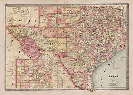
Sold2017Cram: Antique Map of Texas, Indian Territory, ArkansasTitle/Content of Map: 1885 Cram Map of Texas, [verso] Indian Territory and Arkansas -- Texas, [verso] Indian Ty; Arkansas Date Printed: 1885, Chicago Cartographer: G Cram Size: 12 x 17 in. This is a nSee Sold Price
Sold2017Cram: Map of Texas, Indian Terretory, Arkansas, 1885Map: 1885 Cram Map of Texas [verso] Indian Terretory [and] Arkansas -- Texas [verso] Indian Ty. [and] Arkansas Cartographer: G Cram Year / Place: 1885, Chicago Map Dimensions: 11.8 x 17 in. A very detSee Sold Price
Sold20171887 Baldwin's Orange Directory Pocket Map of the CityBook 4"x6" Map 28"x21", Copyright 1885See Sold Price
Sold2018Scarce 1875 hand-colored map of Texas by HardestyReserve Reduced! Attractive map of Texas and Indian Territory, colored by counties, from the very scarce Jones & Hamilton Historical Illustrated Atlas of the World published 1875 by H. H. Hardest. NicSee Sold Price
Sold20221885 Two-page Railroad map of TexasCram’s 1885 double-page railroad map of Texas has exceptional printed color. Every railroad line in the state is highlighted in a heavier black line than such things as county borders, rivers anSee Sold Price
Sold2020Reconnaissance Alaska 1885 (20 Maps)Report of a Military Reconnaissance in Alaska made in 1883 by Frederick Schwatka. With twenty fold-out maps. 1885. 121 pp. 3/4 leather with marbled covers and endsheets. Measures 9.375 in. x 6.25 in.See Sold Price
Sold20204 Maps incl. S. August MitchellIncludes 2 S. August Mitchell maps of the middle states 1852 and 1858, Mitchell map of the U.S. and Texas 1839, and Alaska and part of British America by Mast, Crowell, Kirkpatrick 1905See Sold Price
Sold2022Pub. 1885, First Edition, Illustrated Clour Plates, Maps, "Hardesty's Military Historical and"Hardesty's Military Historical and Geographical Illustrated: Special Military History of Ohio, Giving Its Part in the Indian Wars, Border Annals, War 1812, Mexican War and the War of the Rebellion",See Sold Price
Sold2021Lot of 4 Maps: ATLAS ANTIQUUS:12 MAPS OF ANCIENT WORLDLot of 4 Antique Maps from ATLAS ANTIQUUS: TWELVE MAPS OF THE ANCIENT WORLD by Heinrich Kiepert (1818-1899) | Published: Berlin, Dietrich Reimer, 1884-1885 | Each is a Double-Page Colored Map originatSee Sold Price
Sold2020Stieler, Adolph 1905 Lot 4 Maps of the USA, N. AmericaIncl North America Continent, and 3 others showing parts of the USA, one showing part of Texas. Lithograph Maps Published 1905 by Justus Perthes, Gotha for "Stielers Hand-Atlas" by Adolf Stieler. CentSee Sold Price
Sold2024Isothermal Lines of Africa. Sketch map 1885 old antique vintage plan chartTITLE/CONTENT OF MAP: 'Isothermal Lines of Africa' DATE PRINTED: 1885 IMAGE SIZE: Approx 13.5 x 12.0cm, 5.25 x 4.75 inches (Small) TYPE: Antique engraved sketch map CONDITION: Good; suitable for framiSee Sold Price
Sold2021Collection of 4 Vintage Maps, To Include H. MollCollection of four vintage maps, to include two reproduction H. Moll (1654-1732), North America, Mexico, Antarctica, etc 14"h x 12"d/ largest Provenance: A San Antonio, TX Collection We happily providSee Sold Price
Sold2021Texas and the southwest with northern Mexico. ByTitle: Texas and the southwest with northern Mexico. By Bonne/Raynal 1780 Date/Period: 1780 Materials: Copperplate engraved Size: 13 1/2 x 9 3/4'' Detailed maps shows the modern state of Texas, LouisiSee Sold Price
Sold20171882 Historical Hand Atlas, H. H. Hardesty Map1882 Historical Hand Atlas Illustrated, H. H. Hardesty 11.5 X 15. This Hard-to-find Atlas Has Been Rebound—it Will Look Great on Your Shelf. Several State Maps (texas/indian Territory, California/laSee Sold Price
Sold2023MITCHELL'S NEW MAP of TEXAS, OREGON & CALIFORNIA1846 Philadelphia, S. Augustus Mitchell. hardcover leather bound. 5 1/4 x 3 1/4 inches. Map unfolded 22 x 20 1/2 inches and presented in a custom frame 23 1/2 x 22 inches (overall)See Sold Price
Sold20221883 Hardesty Map of Pennsylvania -- Map of PennsylvaniaTitle: 1883 Hardesty Map of Pennsylvania -- Map of Pennsylvania Cartographer: H Hardesty Year / Place: 1883, Chicago Map Dimension (in.): 12.8 X 19.4 in. This is an excellent map of Pennsylvania. GreaSee Sold Price
Sold2022Main currents of the American Mediterranean.Caribbean/Gulf of Mexico 1885 mapTITLE/CONTENT OF MAP: 'Main currents of the American Mediterranean' DATE PRINTED: 1885 IMAGE SIZE: Approx 9.0 x 11.0cm, 3.5 x 4.25 inches (Small) TYPE: Antique wood-engraved map; Scale 1:45,000,000 COSee Sold Price
Sold20201853-4 Whipple Map of Parts of Arkansas, IndianTitle: 1853-4 Whipple Map of Parts of Arkansas, Indian Territory, Texas and New Mexico -- Map No. 1 From Fort Smith to the Rio Grande…under the direction of the Hon. Jefferson Davis, Secretary of WaSee Sold Price
Sold2023Disputed Terr. Haiti Santo Domingo. Hispaniola. Hispaniola 1885 old mapDisputed territory between Haiti and San Domingo' by Engraved for Élisée Reclus (1885). Antique wood-engraved map; Scale 1:7,000,000, 8.5 x 11.0cm, 3.25 x 4.25 inches TITLE/CONTENT OF MAP: 'See Sold Price
Sold20221885 French Map Of The Amazon19th century map of the Amazon by H. A. Coudreau. Dated 1885. 7 1/4 x 19 7/8 inches (sheet size). Four fold creases, as produced, otherwise very good condition.See Sold Price
Sold2024Copacabana Peninsula, Lake Titicaca. Andean States. Bolivia Peru 1885 old mapTITLE/CONTENT OF MAP: 'Copacabana Peninsula' DATE PRINTED: 1885 IMAGE SIZE: Approx 10.5 x 11.0cm, 4.25 x 4.25 inches (Small) TYPE: Antique wood-engraved map; Scale 1:1,000,000 CONDITION: Good; suitablSee Sold Price
May 10Rail & Road AuctionsEleven Army Corps of Engineers Port Series No. 1 Through No. 8 Books with Fold Out Maps$35(2 bids)


![Cram: Antique Map of Texas, Indian Territory, Arkansas: Title/Content of Map: 1885 Cram Map of Texas, [verso] Indian Territory and Arkansas -- Texas, [verso] Indian Ty; Arkansas Date Printed: 1885, Chicago Cartographer: G Cram Size: 12 x 17 in. This is a n](https://p1.liveauctioneers.com/5584/113749/58452563_1_x.jpg?height=310&quality=70&version=1513734097)
![Cram: Map of Texas, Indian Terretory, Arkansas, 1885: Map: 1885 Cram Map of Texas [verso] Indian Terretory [and] Arkansas -- Texas [verso] Indian Ty. [and] Arkansas Cartographer: G Cram Year / Place: 1885, Chicago Map Dimensions: 11.8 x 17 in. A very det](https://p1.liveauctioneers.com/5584/104739/53636876_1_x.jpg?height=310&quality=70&version=1496416470)