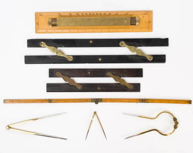
Sold2021Antique & Vintage Marine Map Chart AccessoriesA group of six very good marine map chart accessories, consisting of: two antique ebony & brass parallel rules - the 12" rule stamped THREADWELL LONDON, the 18" rule with minor chips, a 15" antique brSee Sold Price
Sold20231763 Map Chart of Polar Circle and MagazineChart of the Antarctic Polar Circle with the Countries Adjoining, According to a New Hypothesis of Mr. Bauche, from the memoirs of the Royal Academy of Paris, published for Gentleman's Magazine JanuarSee Sold Price
Sold2021Early California/Nevada Desert Survey Maps (17)A group of 17 maps that chart the areas of desert in eastern California and Nevada. Sixteen of the maps measure 21"x 16" and one, showing the Kingman, Arizona and California southern desert regions meSee Sold Price
Sold2017Antarctic South Pole Drift Ice Limit 1886 MapAntarctic. South Pole. Drift Ice Limit. Wilkes Graham Victoria Land, 1886 Map. Title/content of Map: 'south Polar Chart' date Printed: 1886 image Size: Approx 15.0 X 21.0cm, 6 X 8.25 Inches (medium) tSee Sold Price
Sold2022[POLAR EXPLORATION]. A group of 27 booklets, maps, pamphlet...[POLAR EXPLORATION]. A group of 27 booklets, maps, pamphlets and 1 poster and 1 book related to Antarctic travel and exploration. [V.p., v.d.] 4tos and 8vos. Publisher’s wrappers or cloth bindinSee Sold Price
Sold2024Puerto Rico Antique Maps (3)Group of 3 antique folding map sea charts. One of Puerto Rico. Another of San Juan Harbor. The third a composite including Mayaguez Bay. Washington, D.C.: 1899. All fold as issued.See Sold Price
Sold2023Group of Antique Polar Maps (4)Four Antique maps relating to the polar regions. The World in Three Sections, Alexander Hogg. North Pole, Emanuel Bowen. North Pole from Carey's Edition of Guthrie's Geography Improved. Polus ArcticusSee Sold Price
Sold20171851 Tallis Map of Islands in the Atlantic1851 Tallis Map of Islands in the Atlantic J. Tallis 1851 London 14 x 10 in. plus matting Beautiful steel engraved map consisting of four maps of the islands: the island groups of Cape Verde, CanariesSee Sold Price
Sold2023(AVIATION -- AERONAUTICAL PLANNING CHARTS.) U.S. Coast and Geodetic Survey; and others. Group of(AVIATION -- AERONAUTICAL PLANNING CHARTS.) U.S. Coast and Geodetic Survey; and others. Group of approximately 20 mid-twentieth-century American government maps and charts. Various sizes; original folSee Sold Price
Sold2020Group of Astrology Antiquarian Books & Ephemera.Group of Antiquarian books and ephemera relating to Astronomy & Uranology. Astronomical Atlases, Maps and Charts by Basil Brown; Treatise on Astronomy by John F. W. Herschell; Atlas of the Heavens bySee Sold Price
Sold2022[EXPLORATION -- BIBLIOGRAPHIES]. A group of 5 works relating to Arctic exploration in 7 volumes,[EXPLORATION -- BIBLIOGRAPHIES]. A group of 5 works relating to Arctic exploration, comprising:   [DALL, William H. and BAKER, Marcus]. Partial List of Charts, Maps, and Publications Relating toSee Sold Price
Sold2023Sebastian C. Adams - Synchronological Chart, Illustrated Panorama of History, Chronological Chart ofLot 56 Sebastian C. Adams American (1825-1928) Synchronological Chart, Illustrated Panorama of History, Chronological Chart of Ancient Modern and Biblical History with Maps , Group of 3 (1884) chromoSee Sold Price
Sold2021HUNDREDS Nautical, Geology & World Geography MapsAn historical estate collection consisting of hundreds of individual maps and charts, produced by and for various sources. Includes original U.S. Geological Survey maps, National Geographic Society woSee Sold Price
Sold2019Group of Three Maps by Antonio Zatta (1757-1797,Group of Three Maps by Antonio Zatta (1757-1797, Venice), consisting of "Essex/Middlesex," 1779; "Surrey/Kent," 1779; and "L'Estremadura di Portogallo Alentejo ed Algarue," 1775; Algarue- H. - 14 in.,See Sold Price
Sold2019Group of Three Maps by Antonio Zatta (1757-1797,Group of Three Maps by Antonio Zatta (1757-1797, Venice), consisting of "L'Asia divisia ne' Suoi Principali Stati," 1777; "Parte de Regno D'lrlanda le Provincie D'Ulster e Leinster," 1778; and "La RusSee Sold Price
Sold2019Group of Three Maps by Antonio Zatta (1757-1797,Group of Three Maps by Antonio Zatta (1757-1797, Venice), consisting of "Li Regni, di Valenza, e Murcia," 1775; "Li Regni Galizia, Asturies, Leon, Castiglia Vecchia," 1776; and "Li Circon D'Austria eSee Sold Price
Sold2019Group of Three Maps by Antonio Zatta (1757-1797,Group of Three Maps by Antonio Zatta (1757-1797, Venice), consisting of "II Regno di Scozia," 1776; "Carte Septentrinale lnghilterra Principato ai Galles," 1778; and "Carte Meridionale Galles," 1778,See Sold Price
Sold2019Group of Three Maps by Antonio Zatta (1757-1797,Group of Three Maps by Antonio Zatta (1757-1797, Venice), consisting of "L'Esremadura a la Castiglia Nuova," 1776; "Andalusia e Granada," 1776; and "La Catalogna Li Regni Di Aragona ed Alta Navarra,"See Sold Price
Sold2017Polar Regions Arctic/Antarctic Sea Chart, 1914Title/Content of Map: 'The Polar Regions; Arctic Regions; Antarctic Regions; Inset Greenland; Spitzbergen; The Bering Strait and Lower Yukon; Weddell Sea; Ross Sea' This map is folding hence the centrSee Sold Price
Sold2020Grp: 6 Maps of the Middle East BiblicalGroup of six maps of the Middle East, many Biblical. Includes Nicolas Sanson (1600-1677)"Kaart can de Reis-Tochten en Verblyf-Plaat der Heilige Apostelen Petrus en Paulus," Amsterdam; "A Chart of theSee Sold Price
SoldGroup of railroad ephemera from the 1939 New York World's FairGroup of railroad ephemera from the 1939 New York Worlds Fair consisting of railroad maps Railroads on Parade Pennsylvania Railroad etc in very good to excellent condition as seen in the photos.See Sold Price
Sold2020(CELESTIAL.) Cellarius, Andreas. Typus Aspectuum,(CELESTIAL.) Cellarius, Andreas. Typus Aspectuum, Oppositionum et Coniuntionum Etz in Planetis. Hand-colored double-page engraved celestial chart with a map of the world on a north-polar projection shSee Sold Price
SoldGroup of mixed ephemera from the 1939 New York World's FairGroup of mixed ephemera from the 1939 New York Worlds Fair consisting twenty three items maps hotels facts booklets etc in very good to excellent condition as seen in the photos.See Sold Price
Sold2021Group of tax rate signs, maps, magazinesPause for Living, Michigan sales tax chart, California and Oregon mapsSee Sold Price
Featured18 hrs LeftJasper52Antique sea 'Chart of the Islands of Cape Verd' [Verde]. MOUNT & PAGE 1758 map$260
May 09Hunt and Peck Estate Services, Inc.William Hole "A Description of the land of Gosen, and Moses passage though the Deserts"$50
May 01Adam's AuctioneersH.C CAREY AND I.LEA (publishers) A Complete Historical, Chronological and Geographical AMERICAN€1,500
BonhamsANSON, GEORGE, BARON. 1697-1762. A Voyage Around the World, in the Years MDCCXL, I, II, III, IV....$240(8 bids)
May 21Hess Fine Auctions1885 A Popular History Of The United States JC Ridpath Gilt Green Leather Book Illustrated$10
May 10Rail & Road AuctionsNine United Air Lines Paper Items - Travel Brochures, Guides, Maps, Information Packet, Flight Log,$30
May 16Potter & Potter Auctions[NEW YORK CITY – PICTORIAL MAPS]. Group of 3 pictorial maps...$200(1 bid)
BonhamsCONNECTICUT AREA MAPS. A group of two maps of Farmington and Plainville, from Atlas of Hartford ...$50(18 bids)
3 days LeftTrillium Antique Prints & Rare BooksBonne - Map of the Eastern Coast of North America$85(3 bids)


![[POLAR]. A group of maps and charts, consisting of: First Image](https://p1.liveauctioneers.com/928/212515/108628950_1_x.jpg?height=300&quality=1&version=1627420959&width=300)
![[POLAR]. A group of maps and charts, consisting of: First Image](https://p1.liveauctioneers.com/928/212515/108628950_1_x.jpg?height=300&quality=95&version=1627420959&width=300)


![[POLAR EXPLORATION]. A group of 27 booklets, maps, pamphlet...: [POLAR EXPLORATION]. A group of 27 booklets, maps, pamphlets and 1 poster and 1 book related to Antarctic travel and exploration. [V.p., v.d.] 4tos and 8vos. Publisher’s wrappers or cloth bindin](https://p1.liveauctioneers.com/928/265343/138523390_1_x.jpg?height=310&quality=70&version=1666130009)


![[EXPLORATION -- BIBLIOGRAPHIES]. A group of 5 works relating to Arctic exploration in 7 volumes,: [EXPLORATION -- BIBLIOGRAPHIES]. A group of 5 works relating to Arctic exploration, comprising:   [DALL, William H. and BAKER, Marcus]. Partial List of Charts, Maps, and Publications Relating to](https://p1.liveauctioneers.com/197/264837/138100238_1_x.jpg?height=310&quality=70&version=1665664223)


![Antique sea 'Chart of the Islands of Cape Verd' [Verde]. MOUNT & PAGE 1758 map (1 of 1)](https://p1.liveauctioneers.com/5584/326140/175576839_1_x.jpg?height=282&quality=70&version=1713288521)


![[NEW YORK CITY – PICTORIAL MAPS]. Group of 3 pictorial maps... (1 of 3)](https://p1.liveauctioneers.com/928/325952/175495562_1_x.jpg?height=282&quality=70&version=1712935174)


