Sold2018UK Road Maps C1750-1785 Lot of 16. Paterson, BowenGood Lot of 16 Copper Engraved Road Maps. 15 by Paterson, Published 1785 by Carrington Bowles, London for "Paterson's British Itinerary" First Edition by Captain Daniel Paterson. Together with one hanSee Sold Price
Sold2023Map: An 18thC engraved strip / road map after John Owen and Emanuel Bowen, showing the road fromMap: An 18thC engraved strip / road map after John Owen and Emanuel Bowen, showing the road from London to Rochester via Deptford, Crayford and Dartford. Approx. 7 1/4" x 4 3/4"See Sold Price
Sold2018Bowen: Antique Map of Kent, 1756Title/Content of Map: Kent Date Printed: 1756 Cartographer: BOWEN, EMANUEL Size (inches): 14.3x10.3 "divided into its lathes containing the cities, burough & market towns, with the roads and distancesSee Sold Price
Sold2022Bowen, Thomas 1782 Large Map of England & Wales"A New & Most Accurate Map of the Roads of England and Wales" Copper Engraved Map Published 1779-82 by J. Cooke, London for "The Modern Universal British Traveller or, a New, Complete, and Accurate toSee Sold Price
Sold2017[Maps] Britannia Depicta, 1720Bowen, Emanuel. BRITANNIA DEPICTA OR OGILBY IMPROV'D; BEING A CORRECT COPPY OF MR. OGILBY'S ACTUAL SURVEY OF ALL YE DIRECT & PRINCIPAL CROSS ROADS IN ENGLAND AND WALES. London: Tho. Bowles, 1720. 8vo.See Sold Price
Sold2021Road Maps by Johnathan Schultz"Road Maps" by Johnathan Schultz is an original 3D sculpture created with 23kt gold leaf on Acrylic, 18kt gold plate. Frame Dimensions 13.5 x 13.5 x 4 inSee Sold Price
Sold2021Shell Tin Litho Road Maps DisplayCanadian. 1940s. Lithographed tin. Includes an assortment of seventeen (17) used road maps. Marked, "St. Thomas Metal Signs Ltd. St. Thomas Ontario" upper rear. 19 1/2 x 13". One added mounting hole tSee Sold Price
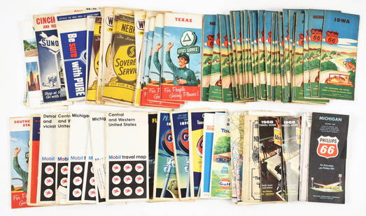
Sold2020Approximately 50 Antique Service Station Road MapsCirca 1920s-30s, Includes Nebraska, Michigan, Missouri, Iowa, Standard Oil, Sinclair, Shell, and MoreSee Sold Price
Sold2021Mobilgas road maps brochure displayMetal display with approximately 8- various maps. Includes several from Ohio, New York, Nebraska, Buffalo -Niagara, Minnesota and New England. 12 3/4 in wide 24 in tall.See Sold Price
Sold2022HUSKY GASOLINE SERVICE STATION MAP DISPLAY W/ HUSKY ROAD MAPS.SST. An excellent and complete example of this Circa 1950's Service Station Road Map Display from Husky showing a Tin Husky Sign at the face and complete with Maps. CONDITION: Display is in overall exSee Sold Price
Sold2020MOBIL GASOLINE SERVICE STATION TIN ROAD MAPS DISPLAY W/SST. A very nice example of this Service Station Road Maps Display from Mobil Gasoline. The paint and body are both in excellent condition, showing minimal age wear and minor surface scratches. The grSee Sold Price
Sold2022British road maps.- Ogilby (John) The Roads fromNO RESERVE British road maps.- Ogilby (John) The Roads from Chelmsford in Essex to St. Edmonds-Bury in Suffolk & Saffron-Walden in Essex, strip road map, engraving with hand-colouring, on thin laid paSee Sold Price
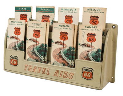
Sold2023Vintage Phillips 66 Road Map Embossed Display RackVintage Phillips 66 embossed plastic road map display rack full with original 1930s Phillips 66 maps. Rack has discoloration, some expected chips/ cracks, and wear from use and age. Displays well withSee Sold Price
Sold2023John Ogilby, Three Engraved Road Maps on laid paperJOHN OGILBY (Scottish, 1600-1676), Three Double Paged Hand Colored Engraved Road Maps on laid paper, including "The Road from London to St. Davids in Com. Pembroke," "The Road from London to St. NeottSee Sold Price
Sold2020Group of 30 Antique Service Station Road MapsCirca 1920s-30s, Includes Standard Oil, Sinclair, Esso, Phillips 66, Missouri, South Dakota, Ohio, Pennsylvania, and Many MoreSee Sold Price
Sold20221895 Hudson River NY - Harper & Bros Bicycle Road Map1895 Harper & Brothers advertising bicycle map. Route travels along the Hudson River, from below 181st Street to Sleepy Hollow just above Tarrytown New York. Bicycle Road Maps in Harper's Round TableSee Sold Price
Sold20198 Various Road MapsLot contains Parco, 1931 Sinclair, early Monamotor, 1937 Red Indian, Sinclair, General Violet Ray, early Deep Rock, early Richfield, and 1953 Hancock. Great graphics maps that show good color with somSee Sold Price
Sold2022Gulf Tourgide Service road map display with maps & clipboard9" x 18" x 5"d Gulf road map display with maps & Gulf clipboard showing normal wear. *PLEASE NOTE, THERE IS ONLY ONE WAY TO PAY FOR ONLINE ITEMS IN THIS AUCTION WHICH IS THROUGH LIVE AUCTIONEERS. THISSee Sold Price
Sold2020MOBIL GASOLINE SERVICE STATION TIN ROAD MAPS DISPLAY W/SST. A very nice example of this Tin Service Station Road Map Display from Mobil Gasoline. Tin is in very good condition, showing only minimal age wear and minor areas of paint loss in the corners. ThSee Sold Price
Sold2024Chevron Gasoline Road Maps Gas Station DisplayApprox 4 3/8" x 12 1/2" x 20 1/4" tall. If shipping is needed, contact UPS Store 5528 to get a shipping quote BEFORE biddingSee Sold Price
Sold2020Group of 18 : Antique/Vintage Service Station Road MapsCirca 1920s-40s,:Ê Includes Ohio, Kentucky, Sohio, Gulf, Amoco, and moreSee Sold Price
Sold2017100 road maps, etc100 road maps and1920’s Rickenbacker Boston dealer promotional letter folderSee Sold Price
Sold2020Group of 30 Antique Service Station Road MapsCirca 1920s-30s, Includes Standard Oil, Sinclair, Shell, Gulf, Illinois, New York, Chicago, Alabama, and Many MoreSee Sold Price
Sold2022LARGE COLLECTION OF VARIOUS SERVICE STATION COMPANY ROAD MAPS.Large Collection includes over sixty individual Service Station Highway Maps from various Oil Companies such as Phillips 66, Sovereign Service, Mobil, Pure, Sinclair and others. Maps are all in fair cSee Sold Price
May 19Rich Penn AuctionsPetroliana Oil Company Road Maps (45), assorted states & companies, most Phillips 66 & Chevron$50
May 19Rich Penn AuctionsPetroliana Oil Company Road Maps (50), assorted states & companies, most Phillips 66 & Gulf$50
May 19Rich Penn AuctionsPetroliana Oil Company Road Maps (50), assorted states & companies, most Mobil & Gulf 1940s-50s-60s,$50
1 day LeftJasper52London Greenwich Chatham Sittingbourne Canterbury Dover OGILBY road map #28 1675$280
5 days LeftClaydon Auctioneers LtdA quantity of assorted 20thC Bartholomew road maps to include Cambridge, Dorset, New Forest, Sussex,£20
1 day LeftJasper52The World including the late discoveries by Captn Cook… by Thomas BOWEN 1789 map$500
1 day LeftJasper52The South Pole with the track of HMS Resolution. Cook. Antarctic. BOWEN 1776 map$300


![[Maps] Britannia Depicta, 1720: Bowen, Emanuel. BRITANNIA DEPICTA OR OGILBY IMPROV'D; BEING A CORRECT COPPY OF MR. OGILBY'S ACTUAL SURVEY OF ALL YE DIRECT & PRINCIPAL CROSS ROADS IN ENGLAND AND WALES. London: Tho. Bowles, 1720. 8vo.](https://p1.liveauctioneers.com/3532/111460/57224161_1_x.jpg?height=310&quality=70&version=1509131847)