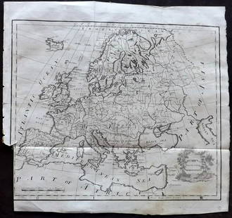
Sold2022Extremely rare map of Europe by John Cooke, 1800Highly unusual circular format makes this extremely rare map even that much more special. From The Universal Atlas of John Cooke, published in 1802. Full original hand color. A clean, sound map that wSee Sold Price
Sold2023Extremely rare map of Germany by John Cooke, 1800Desirable and rare miniature map in a circular format. From an 1802 edition of The Universal Atlas, published by John Cooke and J. Harris in London. Full original hand color. Tiny water stain at top pSee Sold Price
Sold2022Extremely rare map of Denmark by John Cooke, 1802Desirable and very rare miniature map of Denmark in a circular format, which is extremely unusual. From an 1802 edition of The Universal Atlas, published by John Cooke and J. Harris in London. Dated JSee Sold Price
Sold2023Very rare map of Norway and Sweden, John Cooke, 1802Extremely rare miniature map in an unusual circular format. From an 1802 edition of The Universal Atlas, published by John Cooke and J. Harris in London. Dated Jan. 1, 1802. Full original hand color.See Sold Price
Sold2022John Smith Map of New England, Extremely Rare 2nd StateSMITH, John (1580-1631). New England the most remarqueable parts thus named by the high and mighty Prince Charles, Prince of great Britaine. Observed and described by Captayn John Smith... CopperplateSee Sold Price
Sold2023Lizars, Daniel 1831 LG Rare HC Map. Europe on 2 SheetsLarge Folio Copper Engraved Map Published 1831-2 by John Hamilton, Successor to Daniel Lizars, Edinburgh for "The Edinburgh Geographical and Historical Atlas..." First Edition by Daniel Lizars. Very fSee Sold Price
Sold2023Scarce 1817 Edgefield Dist., S. Carolina map - 1897Scarce 1897 reprint of the extremely rare 1817 Thos. Anderson map. From the 1897 book by John Abney Chapman which is usually found without the map. The 1817 map is the genesis for the 1825 map found iSee Sold Price
Sold2023Lizars, Daniel 1831 LG Rare HC Map. Turkey in EuropeLarge Folio Copper Engraved Map Published 1831-2 by John Hamilton, Successor to Daniel Lizars, Edinburgh for "The Edinburgh Geographical and Historical Atlas..." First Edition by Daniel Lizars. Very fSee Sold Price
Sold20191800 Geography ATLAS MAPS John Walker India Asia World1800 Geography ATLAS MAPS John Walker India Asia World Map John Walker’s ‘Elements of Geography’ is an incredibly late 18th-century English atlas known for its impressive folding maps. This atlaSee Sold Price
Sold2023Thomson, John (Pub) 1825 Map. EuropeCopper Engraved Map Published 1825 by John Thomson, Edinburgh for "The Edinburgh School Atlas" by N. R. Hewitt. Maps Engraved by Hewitt. Original Outline Hand Colour. Rare. Paper Size: 10.5 x 8 inch (See Sold Price
Sold20221871 Confederate 1ed Robert E Lee Civil War Military Army Illustrated CSA Maps1871 Confederate 1ed Robert E Lee Civil War Military Army Illustrated CSA Maps “Human virtue should be equal to human calamity.” ¬¬--Robert E. Lee John Esten Cooke was an American noSee Sold Price
Sold2023Thomson, John (Pub) 1825 Map. Russia in EuropeCopper Engraved Map Published 1825 by John Thomson, Edinburgh for "The Edinburgh School Atlas" by N. R. Hewitt. Maps Engraved by Hewitt. Original Outline Hand Colour. Rare. Paper Size: 10.5 x 8 inch (See Sold Price
Sold2023Russell & Barclay 1839 Hand Col Map. Russia in EuropeHand Colored Copper Engraved Map Published 1823-40, by Fisher & Son, "A Complete Atlas of the World" by John Russell et al. A Very Rare Work which is compiled from the same plates used in different edSee Sold Price
Sold2018Extremely Rare JOHN BELL Cold-Painted Redware Spaniel,Extremely Rare Cold-Painted Redware Figure of a Spaniel, Stamped "JOHN BELL", Waynesboro, PA origin, circa 1840-1880, molded figure of a Cavalier King Charles spaniel on slab base, the surface with orSee Sold Price
Sold2022Extremely Rare John J. French Hutch Soda [151624]THIS BOTTLES/THE/PROPERTY/OF/JOHN J. FRENCH Aqua, 6 3/4" tall. Wiped top. Dates c, 1893-95.Tombstone style slug plate. Double strike letter F on the base. Extremely Rare John J. French hutch bottle ouSee Sold Price
Sold2021Lochhead (Pub) 1811 Rare Map. EuropeCopper Engraved Map Published 1811 by William Lochhead, Berwick for "Modern Geography: And a Compendious General Gazetteer" Rare. Folds as issued. Paper Size: 12 x 10.5 inch (30 x 27cm) Some tone spotSee Sold Price
Sold2017Heavy Bronze plaque. Figures of warrior Ife 1800 circaBenin. Bronze plaque depicting 3 figures of warrior Ife. This plaque was used as ornament of the Royal houses doors. Extremely rare. 1800 circa. 42x30x11 cm. 5,8 Kg.See Sold Price
Sold2015John Hancock Whiskey Enamel Label Shot GlassExtremely Rare John Hancock Whiskey Enamel Label Shot Glass. Robinson & Aronheim Distillers, Detroit, Mich. No chips or cracks. 2 inches tall.See Sold Price
Sold2023Unique map of upper western states printed on card stock, 1867An extremely rare map of Johnson’s Nebraska, Dakota, Idaho and Montana by A. J. Johnson. When the maps were being printed for this 1867 version of Johnson’s New Illustrated Family Atlas, aSee Sold Price
Sold2023Extremely Rare c.1848 Map of Hong KongExtremely Rare c1848 Map of Hong Kong, including reference to the Morrison Society School, a Protestant English langauge school for young Chinese boys. The school was built on what is now Morrison HilSee Sold Price
Sold2020AN ANTIQUE MAP, "Europe (Evrop)," JOHN SPEED,AN ANTIQUE MAP, "Europe (Evrop)," JOHN SPEED, CARTOGRAPHER, 1626-1676, hand-colored engraving on paper, Abraham Goos (1589-1643), engraver, published for merchants Thomas Basset and Richard Chiswell iSee Sold Price
Sold2018Extremely Rare world map in double HemisphereTitle/Content of Map: Extremely Rare world map in double Hemisphere projection Date: 1717 Size: 7.6x10.6†by Feuille published in 1717, Amsterdam. With California as a island. from one of the mostSee Sold Price
Sold2021Walt Disney Imagineering Exclusive Tokyo DisneySea 5thWalt Disney Imagineering Exclusive Tokyo DisneySea 5th Anniversary Poster Map. An extremely rare poster map, not sold to the public. This is the first map to show the Tower of Terror. Bird’s-eyeSee Sold Price
May 09Hunt and Peck Estate Services, Inc.1775 John Hinton Vol. 56 "The Universal Magazine of Knowledge and Pleasure"$50
May 01Doyle New YorkThe Hogan copy of the first edition, first issue of Uncle Tom’s Cabin$5,000
12 hrs LeftTrillium Antique Prints & Rare BooksWebber & Cook, Rare - Waheiadooa, Chief of Oheitepeha, Lying in State$500
12 hrs LeftTrillium Antique Prints & Rare BooksShaw & Nodder - Privet Sphinx Moth Metamorphosis. 443$35
Apr 27Trillium Antique Prints & Rare BooksWebber & Cook, Rare - The Narta, or Sledge for Burdens in Kamtschatka$500
Apr 27Trillium Antique Prints & Rare BooksWebber & Cook, Rare - View in Macao, Including the Residence of Camoens, when he wrote his Lusiad$500
12 hrs LeftLink Auction GalleriesStebbins' New Township Map of Ohio. Stebbins, Henry S. Published by Henry S. Stebbins, New York,$50(1 bid)


![Extremely Rare John J. French Hutch Soda [151624]: THIS BOTTLES/THE/PROPERTY/OF/JOHN J. FRENCH Aqua, 6 3/4" tall. Wiped top. Dates c, 1893-95.Tombstone style slug plate. Double strike letter F on the base. Extremely Rare John J. French hutch bottle ou](https://p1.liveauctioneers.com/2699/254728/132473749_1_x.jpg?height=310&quality=70&version=1657577698)