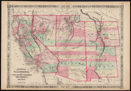
Sold2022Scarce Johnson map of the Great Western states, 1864Antique map of California, Nevada, Utah, Colorado, New Mexico, and Arizona. Published during a great time of expansion and change in the U.S. West, as well as during the Civil War. Here Utah displaysSee Sold Price
Sold2023Scarce Johnson map of the Great Western states, 1864Authentic vintage map of California, Utah, Nevada, Colorado, New Mexico, and Arizona. Created during a great time of expansion and change in the western United States while the Civil War was still ragSee Sold Price
Sold2019Scarce 1855 Colton’s N. America – Johnson & BrowningGreat map of North America with many western states in early configurations or not yet created. Kansas and Utah in elongated states (Utah Territory with its original borders created in 1850). NebraskaSee Sold Price
Sold2018Johnson & Ward: Kansas & Missouri, 1864The scarce and highly detailed map of the pivotal states of Missouri and Kansas near the end of the Civil War, with western Kansas still largely unorganized. In addition to showing major transcontinenSee Sold Price
Sold2022Scarce Johnson's Missouri & Kansas map during CivilLarge double-page map of these two states of great importance during the Civil War. One of Johnson and Ward’s more decorative issues, this map offers a fascinating snapshot of these two hotly cSee Sold Price
Sold2022Texas & western states, 1864 scarce publication by SchonbergTitle: Texas & western states, 1864 scarce publication by Schonberg Date/Period: 1864 Materials: Hand colored steel plate engraved. Size: 14 x 12'' Important map. Shows a massive Idaho territory. 1864See Sold Price
Sold2022Significant United States map, 1864 Johnson & WardVery interesting hand-colored map created at a pivotal time in the settlement of the American West. In this lovely Civil War era map many of the western states have still not settled their borders. ArSee Sold Price
Sold2019Five Antique Maps of the Western United States[Five Antique Maps of the Western United States], incl. "Map of the United States Territory of Oregon...", by Hood, 1838; "Johnson's California, with Utah...", Johnson and Ward, 1864; "Map Showing theSee Sold Price
Sold2022Authentic large-format 1864 map of Palestine, Johnson &Scarce and informative hand-colored map of Palestine with inset of Jerusalem. If you’ve ever wanted to understand about locations mentioned in the Bible, this would be a great map for you. CreaSee Sold Price
Sold2022Scarce 1844 U. S. map w/large Texas, western territoriesOne of the more interesting and elusive school maps of the United States at a time of great territorial expansion. This 1844 double-page Olney school geography map shows the Republic of Texas in one oSee Sold Price
Sold2023Scarce pocket map of Western States, 1855Important and beautiful pocket map in completely sound condition after numerous conservation repairs using the kozo method that will last hundreds of years. Presents very well. Decorative and intricatSee Sold Price
Sold2021Johnson map of American West – great color, 1864Authentic vintage maps of the American West—especially during the years of constant boundary change--are extremely collectible. Exceptional examples with great color and crisp ink impressions arSee Sold Price
Sold20191864 Johnson Map of Texas -- Johnson's New Map of theTitle/Content of Map: 1864 Johnson Map of Texas -- Johnson's New Map of the State of Texas Date: 1864, New York Cartographer: Johnson & Ward Size: 16.7 X 24.5 in. This a double page, large, quite attrSee Sold Price
Sold20181864 Johnson Map of the United States -- Johnson'sTitle/Content of Map: 1864 Johnson Map of the United States -- Johnson's United States Date: 1864, New York Cartographer: A Johnson Size: 16.9 x 23.1 in. This is a large, highly detailed Civil War eraSee Sold Price
Sold20241864 Map1864 map "JOHNSON'S UNITED STATES". Sight 17" x 25 1/2", overall 19" x 27".See Sold Price
Sold2018Transitional western states with Gadsden Terr. – 1860sReserve Reduced! Great map of the West, naming Gadsden Territory as a separate region before it’s named Arizona. Map was issued shortly after the formation of Arizona, Nevada and Wyoming, each of whSee Sold Price
Sold20191863 Johnson Map of Mexico -- Johnson's MexicoTitle/Content of Map: 1863 Johnson Map of Mexico -- Johnson's Mexico Date: 1863, New York Cartographer: A Johnson Size: 12.5 x 15.5 in. Very nice map of Mexico, color-coding the states. Great deal ofSee Sold Price
Sold2022Scarce Texas map (western part) from Asher & AdamsLarge double-page map of Western Portion of Texas with inset of extreme western tip of the state. Shows towns, proposed railroad lines and river, including the Colorado River and the Rio Grande. The fSee Sold Price
Sold20231864 Johnson Map of Texas -- Johnson's New Map of the State of TexasTitle: 1864 Johnson Map of Texas -- Johnson's New Map of the State of Texas Cartographer: Johnson & Ward Year / Place: 1864, New York Map Dimension (in.): 16.7 X 24.5 in. Thisis a double page, superbSee Sold Price
Sold2019Three Maps: consisting of Johnson & Ward, "UnitedThree Maps: consisting of Johnson & Ward, "United States," 1864, hand colored, H.- 17 7/8 in., W.- 26 1/2 in.; together with two copies of Johnson & Ward, "North America," 1861-1863, H.- 26 1/2 in., WSee Sold Price
Sold2022Scarce 1856 Map of Great West, still in bookScarce and fascinating early map of the Plains, Midwest and Rocky Mountains, drawn by E.F. Beadle and published by Miller, Orton & Mulligan in “The States and Territories of the Great West.&rdquSee Sold Price
Sold2023Unique map of upper western states printed on card stock, 1867An extremely rare map of Johnson’s Nebraska, Dakota, Idaho and Montana by A. J. Johnson. When the maps were being printed for this 1867 version of Johnson’s New Illustrated Family Atlas, aSee Sold Price
Sold2023Johnson’s fascinating 1867 North America mapJohnson’s great map of North America showing several western U. S. states with unsettled borders. Wyoming is in a strange configuration and won’t change until its borders are settled witSee Sold Price
Sold2023Scarce 1st ed. Tunison’s California, Oregon, Nevada, 1885Beautiful double-page map of California and western states, from the 1885 Tunison’s Peerles Universal Atlas of the World by H. C. Tunison. WorldCat lists this atlas as Tunison’s first atlaSee Sold Price
5 days LeftJasper521723 Dampier Map of Voyages to Brazil, Australia and Eat Indies -- Voyage du Cap. Dampier a la N.$280
May 16Zikorn Arts & History ObjectsEntrance to Baltic Great & Little Belt 1852 British Admiralty Map$100
3 days LeftGreat Estates Auctioneers & Appraisers1850 ROBERT HORNER MAP OF NEW JERSEY & ADJOINING$125(2 bids)
3 days LeftGreat Estates Auctioneers & AppraisersFREDERIC REMINGTON - PROSPECTING FOR CATTLE RANGE$150
5 days LeftJasper52New Map of That Portion of North America Exhibiting the United States and Territories...Mexico...$360
5 days LeftJasper521875 Warner & Beers United States Railroad Map -- Railroad Map of the United States$140


![Five Antique Maps of the Western United States: [Five Antique Maps of the Western United States], incl. "Map of the United States Territory of Oregon...", by Hood, 1838; "Johnson's California, with Utah...", Johnson and Ward, 1864; "Map Showing the](https://p1.liveauctioneers.com/268/141383/71622474_1_x.jpg?height=310&quality=70&version=1556895875)