Sold2023Barclay & Findlay 1834 Antique Map. Spain and PortugalSteel Engraved Map Published 1834 by Thomas Kelly, London for "A New and Universal English Dictionary" by the Rev. James Barclay. Maps Drawn & Engraved by Alexander Findlay. Paper Size: 10.5 x 8 inchSee Sold Price
Sold2021Findlay, Alex C1835 Antique Map. Spain & PortugalSteel Engraved Map Published C1835 by Thomas Kelly, London for "A New and Universal English Dictionary" by the Rev. James Barclay. Maps Drawn & Engraved by Alexander Findlay. Paper Size: 10.5 x 8 inchSee Sold Price
Sold2023Barclay, James 1834 Antique Print. Madrid, SpainSteel Engraving Published 1834 by Thomas Kelly, London for "A New and Universal English Dictionary" by the Rev. James Barclay. Maps Drawn & Engraved by Alexander Findlay. Paper Size: 10.5 x 7 inch (27See Sold Price
Sold2023Barclay & Findlay 1834 Antique Map. AfricaSteel Engraved Map Published 1834 by Thomas Kelly, London for "A New and Universal English Dictionary" by the Rev. James Barclay. Maps Drawn & Engraved by Alexander Findlay. Paper Size: 10.5 x 8 inchSee Sold Price
Sold2023Barclay & Findlay 1834 Antique Map. EuropeSteel Engraved Map Published 1834 by Thomas Kelly, London for "A New and Universal English Dictionary" by the Rev. James Barclay. Maps Drawn & Engraved by Alexander Findlay. Paper Size: 10.5 x 8 inchSee Sold Price
Sold2023Barclay & Milton C1810 Antique Map. Spain & PortugalCopper Engraved Map Published C1810, London for "Barclay's Universal Dictionary" by James Barclay. Original outline hand colour. Maps Engraved by W. Milton. Paper Size: 10.5 x 8.5 inch (27 x 22cm) GooSee Sold Price
Sold2023Russell & Barclay C1825 Antique Map. Spain and PortugalCopper Engraved Map Published C1825., by Fisher & Son, "A Complete Atlas of the World" by John Russell et al. The companion Atlas to "A Complete and Universal English Dictionary" by James Barclay. PapSee Sold Price
Sold2019Barclay, James 1809 Antique Map. Spain and Portugal"The Kingdoms of Spain and Portugal &ca" Outline Hand Coloured Copper Engraved Map Published 1809, Leeds for "Barclay's Complete and Universal Dictionary of the English Language..." by the Rev. JamesSee Sold Price
Sold2023Findlay, Alexander 1828 Mixed Lot of 10 Antique MapsIncl Low Countries, Austrian Dominions, Spain & Portugal, Russian Empire, Switzerland, Turkey in Asia, Turkey in Europe, Asia Continent, Germany, Prussia. Copper Engraved Map Published 1828, London foSee Sold Price
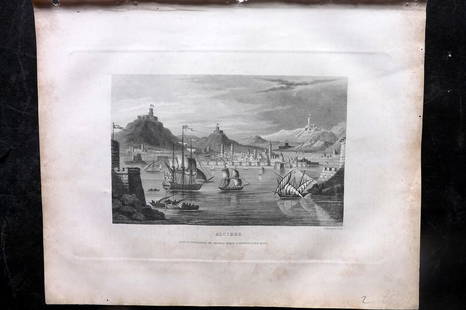
Sold2023Barclay, James 1834 Antique Print. Naples, Italy. ShipsSteel Engraving Published 1834 by Thomas Kelly, London for "A New and Universal English Dictionary" by the Rev. James Barclay. Maps Drawn & Engraved by Alexander Findlay. Paper Size: 10.5 x 8 inch (27See Sold Price
Sold2023Barclay, James 1834 Antique Print. Algiers, Ships, AlgeriaSteel Engraving Published 1834 by Thomas Kelly, London for "A New and Universal English Dictionary" by the Rev. James Barclay. Maps Drawn & Engraved by Alexander Findlay. Paper Size: 10.5 x 8 inch (27See Sold Price
Sold2023Barclay, James 1834 Antique Print. Paris, FranceSteel Engraving Published 1834 by Thomas Kelly, London for "A New and Universal English Dictionary" by the Rev. James Barclay. Maps Drawn & Engraved by Alexander Findlay. Paper Size: 10.5 x 8 inch (27See Sold Price
Sold2021Guthrie, William 1790 Antique Map. Spain & PortugalCopper Engraved Map Published 1790, London for "A New Geographical, Historical and Commercial Grammar..." by William Guthrie. The maps are by John Senex, Thomas Kitchin and others. Folds as issued. EaSee Sold Price
Sold2023Baedeker, Karl 1901 Lot of 34 Antique Maps. Spain & Portugal incl MajorcaIncl 2 of Majorca and one of Gibraltar. Lithograph Maps Published 1901, Leipzig for "Spain and Portugal. Handbook for Travellers" by Karl Baedeker. Folds as issued. Paper Size: Up to 10.5 x 8 inch (27See Sold Price
Sold2023Baedeker, Karl 1901 Lot of 34 Antique Maps. Spain & Portugal incl MajorcaIncl 2 of Majorca and one of Gibraltar. Lithograph Maps Published 1901, Leipzig for "Spain and Portugal. Handbook for Travellers" by Karl Baedeker. Folds as issued. Paper Size: Up to 10.5 x 8 inch (27See Sold Price
Sold2017Homann: Antique Map of Spain & Portugal, 1753Title/Content of Map: 1753 Homann Map of Spain and Portugal -- Regnorum Hispaniae et Portugalliae, Tabula generalis de l' Isliana, aucta et ad Usum Scholarum… Date Printed: 1753 Nurnberg CartographeSee Sold Price
Sold2017Millar: Antique Map of Spain & Portugal, 1768Title/Content of Map: 1768 Millar Map of Spain and Portugal -- A New and Complete Map of Spain and Portugal Date Printed: 1768 c. Cartographer: G Millar Size: 14.3 x 9.3 in. Condition: Good - fair. SeSee Sold Price
Sold2017Sayer: Antique Map of Spain & Portugal, 1780Map: Kingdoms of Spain and Portugal, Divided Into Their Great Provinces Publication Date: 1780-03-02 Cartographer: SAYER, ROBERT Publisher: ROBERT SAYER Size: Folio – 18.50 H x 25.25 W Inches ShortSee Sold Price
Sold2021Kitchin, Thomas 1785 Antique Map of Spain & Portugal"Spain and Portugal drawn from the latest and best Authorities" Copper Engraved Map Published 1783-85, London for "A New Geographical, Historical and Commercial Grammar..." by William Guthrie. Drawn aSee Sold Price
Sold2018SDUK: Antique Map of Spain & Portugal, 1845Title/Content of Map: 'SPAIN AND PORTUGAL' IBERIA Date Printed: 1845 Image Size: Approx 31.0 x 39.0cm, 12 x 15.5 inches (Large) Type: Antique steel engraved map with original outline hand colouring CoSee Sold Price
Sold2018Stackhouse: Antique Map Ancient Spain & Portugal, 1783Title/Content of Map: Ancient Spain & Portugal by Stackhouse Date Printed: 1783 Cartographer: Thomas Stackhouse Material/Medium: Paper Size: 16" x 20" Original hand color, copperplate engraved. PublisSee Sold Price
Sold2020Walker, John 1815 Antique Map of Spain & PortugalCopper Plate Published 1815, London for "The Universal Gazetteer: Being a Concise Description" [Walker's Geography] by John Walker. Folds as issued. Paper Size: 10 x 8 inch (25 x 20cm) Minor toning/ofSee Sold Price
Sold2017Cram: Antique Map of Spain & Portugal, 1887Title: Map of Spain and Portugal by Cram Date: c 1887 Dimensions (inches): 13.5 x 11 Medium: Wax Engraving Condition: Good Condition George F. Cram (1842-1928) served in the U.S. Army during the AmeriSee Sold Price
Sold2021Barlow 1807 Antique Map. Spain and PortugalCopper Engraved Map Published 1807 by Brightly & Kinnersley, Bungay, England for "A General View of the World, Geographical, Historical and Philosophical" by The Rev. E. Blomfield. Engraved by Barlow.See Sold Price
6 days LeftJasper52Chart of the Sea Coasts Biscay & Gallicia [Galicia]. Spain MOUNT & PAGE 1758 map$360
6 days LeftJasper52La Biscaia. Biscay / Vizcaya. Spanish Basque country. ROSSI / CANTELLI 1696 map$280
6 days LeftJasper52The town & castle of St. Augustine. 1740 siege. Spanish Florida. SILVER 1740 map$280
6 days LeftJasper52London Water Supply. Proposed aqueduct Watford-Primrose Hill. TELFORD 1834 map$280
6 days LeftJasper52Cary's reduction of his large map of England & Wales'. Turnpikes canals &c 1834$360
6 days LeftJasper52Cary's reduction of his large map of England & Wales'. Turnpikes canals &c 1834$360
May 16Zikorn Arts & History ObjectsWest Indies, Providence, Windward, Cuba 1834 British Admiralty Map$100
5 days LeftJasper521760 MAP CARTE PARTICULIERE DE L'ISLE DE JUAN FERNANDES antique Robinson Crusoe$55
1 day LeftTrillium Antique Prints & Rare BooksKarl Bodmer - Abdih Hiddisch, A Minitarre Chief. 24$300
1 day LeftTrillium Antique Prints & Rare BooksKarl Bodmer - Mehkskeme-Sukahs (Blackfoot-chief), Tatsicki-Stomick (Piekann Chief). 45$300
1 day LeftTrillium Antique Prints & Rare BooksPowell - 4 Prints of Native American Tools or Adornments$50


![Walker, John 1815 Antique Map of Spain & Portugal: Copper Plate Published 1815, London for "The Universal Gazetteer: Being a Concise Description" [Walker's Geography] by John Walker. Folds as issued. Paper Size: 10 x 8 inch (25 x 20cm) Minor toning/of](https://p1.liveauctioneers.com/3952/179417/90414988_1_x.jpg?height=310&quality=70&version=1600436726)


![Chart of the Sea Coasts Biscay & Gallicia [Galicia]. Spain MOUNT & PAGE 1758 map (1 of 1)](https://p1.liveauctioneers.com/5584/326140/175577208_1_x.jpg?height=282&quality=70&version=1713288521)


