Sold2015AFTER GERARD VALCK MAP 1827AFTER GERARD VALCK (1651-1726), MAP, 1827, 17'' X 21'', MAPPE MONDE GEO HYDROGRAPHIQUE DU GLOBE, NOT FRAMED:Engraved, hand colored map showing the southern polar region, northern polar regions, and twSee Sold Price
Sold2024MAP, France, ValckNorthwestern France. Valck, Normannia Ducatus, tum Superior ad Ortum, tum Inferior ad Occasum, Praefectura Generalis; in qua Distinctissime Exhibentur ejus Archiepiscopatus Rothomagensis..., 1700 (cirSee Sold Price
Sold2017Antique Engraved Map of Oxfordshire, England. c.1670sMap of Oxfordshire c.1670s by Gerard Valck (1651-1726) & Pieter Schenk (1660-1711) of Amsterdam, between 1670 and 1690. . Title. Oxonium comitatus vulgo Oxfordshire. Amstelaedami (Amsterdam) apud GeraSee Sold Price
Sold2016Southern France at Marseilles. Dutch School.Maker: Dutch School. Amsterdam, Gerard Valck, 1700. Medium: Original engraving with hand-coloring of Southern France at Marseilles. Sheet size: 31 1/2 x 24 1/8 in. No Reserve: This lot starts at $1 anSee Sold Price
Sold2020BLAEU, JOAN; and VALCK, GERARD. Novus PlaniglobiiBLAEU, JOAN; and VALCK, GERARD. Novus Planiglobii Terrestris per Utrumque Polum Conspectus. Double-page engraved double-hemispheric world map on a polar perspective. 20¼x23¾ inches sheet sizSee Sold Price
Sold2023[MAP] VALCK. MAPPE-MONDE GEO-HYDROGRAPHIQUE (1686)Valck, Gerard. MAPPE-MONDE GEO-HYDROGRAPHIQUE, OU DESCRIPTION GENERAL DU GLOBE TERRESTRE ET AQUATIQUE EN DEUX-PLANS-HEMISPHERES... Amsterdam, (circa 1686). Beautiful map, fully handcoloured, richly deSee Sold Price
Sold2020Mercator & Hondius C1610 Map of Alsace, France (Fault)"Alsatia Inferior" Copper Engraved Map Published 1607-10, Amsterdam & Dordrecht for "Atlas Minor" by Jodocus Hondius & Gerard Mercator. Paper Size: 8.5 x 7 inch (22 x 18cm) Large chip at bottom, slighSee Sold Price
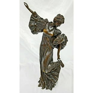
Sold2022AGATHON LEONARD (FRANCE, 1841-1923) - PR ART NOUVEAU BRONZE FIGURES"Danseuse Chantant" and "Danseuse Au Cothurne", gilded bronze sculptures, signed "A. Leonard, Sclp", with round Susse Freres Paris foundry mark, and stamped M (edition), depicting elegant dancers in mSee Sold Price
Sold2019Gerard Valck (1652-1726), "Novus Planiglobi TerrestarisGerard Valck (1652-1726), "Novus Planiglobi Terrestaris per Utrumque Polum Conspectus," 1695, hand colored, H. - 20 1/4 in., W. - 23 3/4 in.See Sold Price
Sold2022Large Scale Abstract Painting by Gerard Leonard van den EerenbeemtLarge scale abstract painting by Gerard Leonard van den Eerenbeemt, Dutch, circa 1963, It is executed in oil on canvas with mixed media, and signed to the lower left. It measures an impressive 49.5" wSee Sold Price
Sold2023Agathon Leonard, France (1841-1923) Bronze.Agathon Leonard, France (1841-1923) Bronze Figure "Danseuse au Cothurne" . This Model was Created in the Late 19th Century. Signed on the Back.Condition: Generally Very Good w/ a Couple of Minor ScratSee Sold Price
Sold2023ALEXANDRE LEONARD (FRANCE, 1821-1877).Eagle With Prey. Bronze sculpture. Signed on base. From a New Rochelle, NY estate collection. - Dimensions: 9.5" h x 14" w x 6.5" d.See Sold Price
Sold2019Gerard Valck (1652-1726), "Virginiae Partis Australis,Gerard Valck (1652-1726), "Virginiae Partis Australis, et Floridae Partis Orientalis, Intejacentiumq Regionum Nova Descriptio," c. 1690, hand colored, H. - 20 1/8 in., W. - 24 1/4 in.See Sold Price
2023CHARLES LEONARD (FRANCE, 19th-20th C.).Patinated and gilt bronze bust of a beauty. Signed on base. From a Scarsdale, NY estate. - Dimensions: 17"HSee Sold Price
Sold2016[Wall map] FranceCarte de la France, 1790.Incisione in coloritura coeva, 1200x1160 mm.See Sold Price
Sold2021Jean Jolivet Map, FranceGalliae Regni Potentiss", hand colored engraving by Jean Olivet, with text verso. Toning, spotting, tears, pencil marks at the lower right, other wear. 18.5" x 23See Sold Price
Sold2024Antique Europe Map/ France. Pieced down in sections. Sight size 26-1/2 x 36 inches. Overall framedAntique Europe Map/ France. Pieced down in sections. Sight size 26-1/2 x 36 inches. Overall framed size is 32 x 42 inchesSee Sold Price
Sold2019Gallia Color Map [France]Galliae Regni Potentiss Color Map with written description in Latin on verso. Map of France with boarders to Germany, Spain and Italy. Appears to be a page from an atlas. Undated. Measures 14 in. x 20See Sold Price
Sold2017EMILE GERARD (FRANCE, B. 1932) ABSTRACT FANTASYFramed oil painting on canvas, Sunset Fantasy, signed lower left Emile Gerard (France, b. 1932), sight: 15"h, 30"w, overall: 16.25"h, 31.25"w, 3lbs Start Price: $80.00See Sold Price
Sold2024MAP, France, HomannWestern France. Johann Baptist Homann, Tabula Ducatus Britanniae Gallis le Gouvernemt. General de Bretagne in suos Novem Episcopatus..., 1720 (circa). Hand Color. Large and very detailed chart roughlySee Sold Price
Sold2019Gerard Valck (1652-1726), "Nouveau Plan du Port et duGerard Valck (1652-1726), "Nouveau Plan du Port et du Ville, D' Acapulco, Vera Cruz," hand colored, H. - 18 1/4 in., W. - 24in.See Sold Price
Sold2016Antique Map : France - 1802Antique Map : France - 1802 from Walker's Geography Gazette. Size : 10.25" x 8.25"See Sold Price
Sold2024An Engraving by Gerard Valck (1652-1726)'Moyse frappe le Rocher' after Gerard Valck (1652-1726) On lined paper with later backing 14 x 19 inchesSee Sold Price
Sold2023MAP, France, AaLyon, France. Pieter van der Aa, Lyon, Capitale du Lyonnois, 1710 (circa). Black & White. This rare and beautifully engraved view of Lyon is surrounded by an ornate architectural border, which was priSee Sold Price
23 hrs LeftLink Auction GalleriesJonathan Callan, English (b. 1961), Map of France, hand colored print$500
May 09Hunt and Peck Estate Services, Inc.Apud Guiljelmum et Johannem Blaeu Map Of French Province Of Nivernais$50
4 days LeftJasper52Large Antique French map GERMAN EMPIRE 1792 colored by POIRSON engraver Basset$170
Apr 27Trillium Antique Prints & Rare BooksPtolemy & Magini, pub. 1620 - Map of France / Verso: Map of Germany$50


![[MAP] VALCK. MAPPE-MONDE GEO-HYDROGRAPHIQUE (1686): Valck, Gerard. MAPPE-MONDE GEO-HYDROGRAPHIQUE, OU DESCRIPTION GENERAL DU GLOBE TERRESTRE ET AQUATIQUE EN DEUX-PLANS-HEMISPHERES... Amsterdam, (circa 1686). Beautiful map, fully handcoloured, richly de](https://p1.liveauctioneers.com/8124/310027/165853628_1_x.jpg?height=310&quality=70&version=1700184289)


![[Wall map] France: Carte de la France, 1790.Incisione in coloritura coeva, 1200x1160 mm.](https://p1.liveauctioneers.com/3336/90951/46934974_1_x.jpg?height=310&quality=70&version=1473763184)


![Gallia Color Map [France]: Galliae Regni Potentiss Color Map with written description in Latin on verso. Map of France with boarders to Germany, Spain and Italy. Appears to be a page from an atlas. Undated. Measures 14 in. x 20](https://p1.liveauctioneers.com/5755/154409/77936853_1_x.jpg?height=310&quality=70&version=1573094011)


