Sold2017British Isles: C England Wales Scotland Ireland MapBritish Isles: Counties. England Wales Scotland Ireland. Tallis/rapkin 1851 Map. Vignettes: London; Edinburgh; Dublin. Approx 36.5 x 26.5cm, 14.5 x 10.25 inches (Large). Antique engraved map by J RapkSee Sold Price
Sold202118th Century Royal Family History of England Plate1) Engraved for Spencer's New History of England. The Royal Family of George III. Plate 1. George Prince of Wales, Frederick Duke of York, William Henry Duke of Clarence, Prince Edward. Published by ASee Sold Price
Sold2023Rapkin, John 1860 Lot of 3 British MapsIncl Channel Islands, England/Wales and Scotland. Steel Engraved Map Published 1860 by The London Printing & Published Company, London for "The Royal Dictionary-Cyclopedia for Universal Reference" bySee Sold Price
Sold2020Rapkin, John 1860 Lot of 5 British & European MapsIncl Scotland, Germany, England/Wales, Denmark and Northern Italy. Steel Engraved Maps Published 1860 by The London Printing & Published Company, London for "The Royal Dictionary-Cyclopedia for UniverSee Sold Price
Sold2020Lyttleton, George 1810 Map of England, Scotland, Wales"An Accurate Map of England, Scotland, and Wales" Copper Engraved Map Published 1810, London for "The History of England..." by George Courtney Lyttleton. Folds as issued. Paper Size: 18 x 14 inch (46See Sold Price
Sold2020Lyttleton, George 1810 Map of England, Scotland, Wales"An Accurate Map of England, Scotland, and Wales" Copper Engraved Map Published 1810, London for "The History of England..." by George Courtney Lyttleton. Folds as issued. Paper Size: 18 x 14 inch (46See Sold Price
Sold2019Lyttleton, George 1810 Map of England, Scotland, Wales"An Accurate Map of England, Scotland, and Wales" Copper Engraved Map Published 1810, London for "The History of England..." by George Courtney Lyttleton. Folds as issued. Paper Size: 18 x 14 inch (46See Sold Price
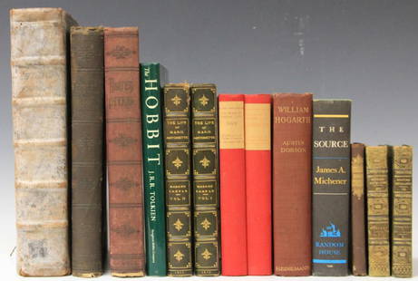
Sold2017LOT OF (13) VINTAGE NOVELS, INCLUDING OLD ENGLISHDante's Inferno, The Life of Marie Antoinette, an Old English book (title is worn off of spine) about History of England, Scotland, Wales and CornwallSee Sold Price
Sold20171835 Bradford Map of British IslandsClean hand-colored 1835 map of the British Islands by the important American mapmaker T. G. Bradford. It includes England, Scotland, Wales and Ireland and covers from the southern tip of the ShetlandSee Sold Price
Sold2022Scotland.- Brown (John) An Historical and Genealogical Tree of the Royal Family of Scotland,Scotland.- Brown (John, genealogist) An Historical and Genealogical Tree of the Royal Family of Scotland, manuscript family pedigree, on thick wove paper, 2 sheets conjoined, numerous folds, foxed andSee Sold Price
Sold2022The royal family of England yacht Britannia 50th anniversary British cup. 1953-2003The royal family of England yacht Britannia 50th anniversary British cup. 1953-2003See Sold Price
Sold2022British Transport RR Police BadgeThis is a police badge for British Transport, which is the special national police force that protects the railway network of England, Scotland, and Wales. Excellent badge in like-new condition, whichSee Sold Price
Sold2020Illustrious Personages of the Nineteenth Century, 1853Portraits of several key figures of the 19th century, including the Royal Family of England, Thomas Chalmers, Sir Robert Peel, Alfred Tennyson, The Emperor Nicholas, Thomas Babington Macauley, Lord JeSee Sold Price
Sold2024Speed, John England, Wales & Scotland and Ireland Described and AbridgedEngland, Wales & Scotland and Ireland Described and Abridged With ye historic relation of thingsworthy from a farr larger volume. [date unclear.] Small oblong 8vo, engraved title-page, 43 maps only (oSee Sold Price
Sold20181814 ATLAS Maps of England & Wales Scotland Color Nav1814 ATLAS Maps of England & Wales Scotland Color Navigation Travel John Cary An incredible atlas consisting of 42 color maps of Great Britain by John Cary. The atlas covers cities in England, Wales,See Sold Price
Sold2019Walker, John 1795 Pair Maps of Scotland, England, WalesCopper Engraved Maps Published 1795, London for "Elements of Geography, and of Natural and Civil History" by John Walker. Centre fold as published. Paper Size: 10 x 8.5 inch (26 x 22cm) Minor toning aSee Sold Price
Sold2022Antique Map Print - Ireland - England - Wales - ScotlandSet of 4 Map Prints. Antique lithographic map originates from "Letts's Popular Atlas", being a series of maps delineating the whole surface of the globe, with many special and original features; and aSee Sold Price
Sold2024Lot of England Royal Family Coronation Pieces.Included are Wedgwood, Royal Doulton, Aynsley, and more. This is a large lot of porcelain, pottery, and pattern glass. The Royal Family members include Elizabeth II, Prince Charles, Princess Diana, PrSee Sold Price
Sold2024Lot of England Royal Family Vintage Souvenirs.Included are tins, postcards, books, dishes, and more. Most of the items appear to center around Queen Elizabeth II, but there are also items featuring Prince Charles, Princess Diana, and more. ThereSee Sold Price
Sold2022Britain.- Mavor (William Fordyce) British Tourists; or, Traveller's Pocket Companion throughBritain.- Mavor (William Fordyce) British Tourists; or, Traveller's Pocket Companion through England, Wales, Scotland, and Ireland, 6 vol., third edition, engraved frontispieces and hand-coloured mapsSee Sold Price
Sold20201789 Leather Set The British TouristFive volume set "The British Tourists; or Traveler' Pocket Companion, Through England, Wales, Scotland, and Ireland..", by William Mavor, printed at London for E, Newberry, 1798. Volume I with frontisSee Sold Price
Sold2021Neale, John C1830 Lot of 35 British Engraved ViewsSteel Engravings Published 1824-31, London for "Views of the Seats of the Noblemen and Gentlemen in England, Wales, Scotland and Ireland" by John Preston Neale, Thomas Moule and others. Paper Size: 8See Sold Price
Sold20201800 The British Tourist Six Vol Set MapsThe British Tourist or Traveller's Pocket Companion Through England, Wales, Scotland, and Ireland.., by William Mavor, printed at London for E. Newberry (others) 1800. Three volumes with folding mapsSee Sold Price
Sold2017Lot of 7 Antique MapsCirca 1796 Lot of 7 Antique Maps; ??Titles: "England, Scotland, Ireland and Wales from the best Authorities" by Cyrus Harris "Hindostan or India from the best Authorities" (Doolittle, sculp.) "SwitzerSee Sold Price
5 days LeftClaydon Auctioneers LtdBook: A 1911 hand illuminated Royal Exchange Assurance Presentation Volume containing illuminated£200
Featured1 day LeftJasper52A Chart of the Coasts of Ireland & part of England. Wales. MOUNT & PAGE 1758 map$550
5 days LeftClaydon Auctioneers LtdBooks: Three books comprising Essays in aid of the Reform of the Church, edited by Charles Gore,£30
1 day LeftJasper52Cary's reduction of his large map of England & Wales'. Turnpikes canals &c 1821$360
1 day LeftJasper52Cary's reduction of his large map of England & Wales'. Turnpikes canals &c 1834$360
1 day LeftJasper52Cary's reduction of his large map of England & Wales'. Turnpikes canals &c 1837$360
1 day LeftJasper52Cary's reduction of his large map of England & Wales'. Turnpikes canals &c 1816$360
1 day LeftJasper52Cary's reduction of his large map of England & Wales'. Turnpikes canals &c 1816$360
1 day LeftJasper52Cary's reduction of his large map of England & Wales'. Turnpikes canals &c 1834$360
1 day LeftJasper52Cary's reduction of his large map of England & Wales'. Turnpikes canals &c 1805$360
1 day LeftJasper52Cary's reduction of his large map of England & Wales'. Turnpikes canals &c 1796$420
1818 AuctioneersEight Royal Mint Queen's Beasts Five Pound Brilliant Uncirculated Coins, 2017 The Lion of England,£30(1 bid)
May 18RbfineartsWilliam Russell (Sir William) Flint 1880-1969 "The Farm Girl And The Nymphs" Watercolor$100
5 days LeftClark's Auction CompanyFinal Interview of Louis The Sixteenth with his Family, in the Temple at Paris, Framed Engraving$80


![Speed, John England, Wales & Scotland and Ireland Described and Abridged: England, Wales & Scotland and Ireland Described and Abridged With ye historic relation of thingsworthy from a farr larger volume. [date unclear.] Small oblong 8vo, engraved title-page, 43 maps only (o](https://p1.liveauctioneers.com/94/316498/169880617_1_x.jpg?height=310&quality=70&version=1705579068)


