Sold20202 antique framed Southern maps2 antique framed maps: Map of South Carolina in German dated 1845. Map of Savannah and Charleston published by G.W and C.B Colton & Co and dated 1855. Overall size measures 25 1/2"h x 28"w and the papSee Sold Price
Sold2018Pre Civil War South Carolina Map Charleston 1847Original hand colored map in overall good condition. Not a repro or restrike. Recently matted and framed using conservation materials. Framed dimensions 23 x 19 inches.See Sold Price
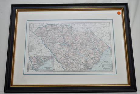
Sold2021HAMMONDS COMPLETE MAP OF SOUTH CAROLINAVintage Hammonds Complete Map of South Carolina. Showing all the railroad routes. c. 1930s. Professionally framed and matted. In frame measures 26 3/4"x20"x 1 1/4". Weight 7 pds. PROVENANCE: A PrivateSee Sold Price
Sold20211856 COLTON MAP CHARLESTON SCMap is from Colton's Atlas Of The World published by J.H. Colton And Company, 1856. Map was of Charleston, South Carolina and Savannah, Georgia. Framed with only Charleston showing. Professionally fraSee Sold Price
Sold20211796 MAP OF NORTH & SOUTH CAROLINA, DENISON, FRAMEJ. Denison (American, 18th century). "Map of North and South Carolina" -1796, from "Morse's Universal Geography", engraving. Framed. Provenance: From the Lifetime Collection of Billy S. Arant, Jr., ChSee Sold Price
Sold20211861 MAP OF COAST OF SOUTH CAROLINAOriginal 1861 Frank Leslies Illustrated News Coast of South Carolina Wood Engraving with later hand coloring. Professionally framed. In frame measures 28"x31"x1". Weight 9 pds. NO IN HOUSE SHIPPING. PSee Sold Price
Sold2018Two Civil War Era Mitchell MapsMap of North America Showing Its Political Divisions and county maps of North Carolina, South Carolina, and Florida on one sheet (Philadelphia: S. Augustus Mitchell, 1860). Not framed. 15.25 x 12.25 iSee Sold Price
Sold20211855 MAP THE CITY OF CHARLESTON, SOUTH CAROLINAMap of the City of Charleston, South Carolina , published by JH Colton & Co, New York in 1855. Good condition. Paper size 11 1/2"x7". Professionally framed and matted. In frame 11 1/2"x15 1/2"x1". WeiSee Sold Price
Sold2020SOUTHERN STATES TRADE ROUTE MAPLarge Framed Trade Route Map showing waterways and towns from the Mississippi River to Charles Town. Geographic Area Covered: Southern States, South Carolina,Santee River Valley, Savannah River ValleySee Sold Price
Sold2015Antique Engraved and Tinted Maplate 18th/early 19th century. Latin map of the Mediterranean by Jannes Jansjonius. framed: H21 1/4" W25 1/2" Private Collection of Dr. Charles Webb, Campobello, South Carolina.See Sold Price
Sold20191867 NORTH + SOUTH CAROLINA MAPOriginal antique map of North and South Carolina published by S. Augustus Mitchell, Jr. Includes inset maps of Charleston Harbor in the bottom left and a Plan of Charleston in the bottom right. It feaSee Sold Price
Sold2021Charleston South Carolina mapCharleston South Carolina map surveyed by Charles Vignoles & Henry Ravenel 1820 I proved for mills atlas 38 inches x 35 inchesSee Sold Price
Sold2017Framed South Carolina Sterling Bond SheetDescription: Framed South Carolina "100 Pound Sterling London Bond" Sheet. Dimensions: Frame - 31.5" x 24". Sight - 21.5" x 14".See Sold Price
Sold2024Framed South Carolina 1890 Bond Sheet100 pounds sterling payable in London, sheet no. 10581..all coupons attached, sight 21 x 14.5 in..toning, foxing, creases, tears, cut-canceled with Xs, scotch tape..frame 28H x 21w x 0.5D Line Item #See Sold Price
Sold2022Antique South Carolina Map with Plan of CharlestonMid to late 19th century (1850-1890). Perhaps a little older. Matted size is 21 x 14 inches.See Sold Price
Sold20231891 Mitchell Map of Maryland, Virginia, North Carolina and South Carolina -- Map of Maryland,Title: 1891 Mitchell Map of Maryland, Virginia, North Carolina and South Carolina -- Map of Maryland, Virginia, North Carolina and South Carolina Cartographer: S Mitchell Year/Place: 1891, PhiladelphiSee Sold Price
Sold20211890 North and South Carolina MapTitle: 1890 North and South Carolina Map Author: Mast Medium: Ink on Paper Dimensions: 13.5"X10.5" Map of North and South Carolina dated 1890. Published by Mast and Crowell. Dated on map. Part of theSee Sold Price
Sold20211930 South Carolina MapAuthor: McNally Title: 1930 South Carolina Map Medium: Ink on Paper Dimensions: 14"X11.5" Map of South Carolina dated 1930. Published in Chicago by the Rand McNally Company. Part of the World Atlas anSee Sold Price
Sold2021Three South Carolina MapsPreliminary Chart of Port Royal Entrance, Beaufort Chechessee and Colleton Rivers... U.S. Coast Survey Office, Superintendent A. D. Bache, triangulation by C. O. Boutelle... 1859, single sheet, engravSee Sold Price
Sold2022CRAIG CRAWFORD (South Carolina, b. 1964) OIL PAINTINGFramed South Carolina Lowcountry Reflections Oil on Canvas by Craig Crawford. As a youth, Craig spent summers and holidays at the family's home on Kiawah Island, SC. In gold leaf wood frame. MeasuresSee Sold Price
Sold2023Rare 1st state of Florida map from 1st printing of 1860 atlasFirst edition, first state of S. A. Mitchell Jr.'s County Map of Florida/County Map of South Carolina. Maps from Mitchell Jr’s first printing of his first New General Atlas are distinguished bySee Sold Price
Sold20192 Hand Colored Maps - Georgia & South CarolinaTwo Gray's Atlas Maps on one sheet - Georgia and South Carolina Inset of Charleston on South Carolina map. Depicts railroad lines, common roads, canals, topography,See Sold Price
Sold2023FRAMED VINTAGE SOUTH CAROLINA WREN & JESSAMINE STAMPVintage framed South Carolina wren & jessamine stamp. Measures 9.5"x11". Weighs 1.5 lbs.See Sold Price
Sold20231841 CHARLESTON, SOUTH CAROLINA HARBOR MAP1841 CHARLESTON, SOUTH CAROLINA HARBOR MAP, lithograph on paper, "Reduced from the Original Survey / of / Major H. Bache U.S.T.E." Housed under glass in a modern frame. 1841. 8" xSee Sold Price
4 days LeftSouth Jersey Auction by Babington Auction IncVintage framed map of South Western Highlands of New Jersey$25(1 bid)
6 days LeftFreeman's | HindmanA carved architectural element of an American Indian with a Pipe, South Carolina, 19th century$1,500
1126 Lots AwayMynt Auctions1940 Penn State Nittany Lions vs South Carolina College Football Program 137534$10(1 bid)
14 hrs LeftAlexander Historical Auctions LLCANNOTATED WORLD WAR II GERMAN LUFTWAFFE NAVIGATION MAP$140
May 18Rich Penn AuctionsDecorative Art, map of South America, late 18th C., framed & matted, Exc cond, 24"H x 20"W overall.$50
5 days LeftMynt AuctionsLouis S. Ehrich Signed 1901 University Ff South Carolina Football Photo USC$900
3 days LeftMynt Auctions1940 Penn State Nittany Lions vs South Carolina College Football Program 137534$10
5 days LeftMynt AuctionsDeebo Samuel Autographed South Carolina Gamecocks Speed Mini Helmet- JSA *Black$10
4 days LeftSouth Jersey Auction by Babington Auction IncFramed map of North America and Central America$25
4 days LeftKCM GalleriesLarge Detailed Original Oil Painting United States Map Julius Lira Salazar 48 x 36 inches$1,800
May 03Leland LittleRomare Bearden (American, 1911-1988), Introduction for a Blues Queen (Uptown at Savoy)$75(2 bids)