Sold2022Group of 9 MapsLot of nine antique maps. 1746 Bellin map of Cape Verde island. H 10" W 14". 1574 Sebastion Munster map from 'Cosmographia Universalis'. H 12-5/8" W 7-1/8". 1598 Sebastion Munster map of Ireland, ScotSee Sold Price
Sold2017Munster: Antique Woodcut Map of Asia Minor, 1574Title: Asia Minor, Woodcut map of Asia Minor with Constantinople Map maker: Sebastian Münster Place and Year: Basel, c. 1574 Dimensions: 12.5 x 18 cm (4.9 x 7.1 in) Technique: Woodblock printing ColoSee Sold Price
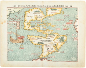
Sold2024Map of Americas circa 1588Rare map of the Americas from the atelier of Sebastian Munster, wood block print modeled after a similar map by Ortelius. Basel, Switzerland, ca. 1588. Purchased through Sothebys, London, 2000.OverallSee Sold Price
Sold2022(AMERICAS.) Sebastian Münster. Die Neuwen Inseln. So Hinder Hispanien Gegeu Orient Bey Dem Land(AMERICAS.) Sebastian Münster. Die Neuwen Inseln. So Hinder Hispanien Gegeu Orient Bey Dem Land India Ligen. Hand-colored double-page woodcut map of North and South America. 12x15 inches sheet siSee Sold Price
Sold2023Munster map of World 1550Heading: (Maps) Author: Münster, Sebastian Title: Das Erst General/inhaltend die beschzeibung und den Circkeldes gantzen Erdtrichs und Moze Place Published: [Basle] Publisher: Date Published: </See Sold Price
Sold2020Sebastian Munster Map of Paris 1550Sebastian Munster (1488-1552), "La ville de Paris, par tout tant renommee, & principalle ville du royaulme de France," ca. 1568. This hand-colored woodcut map of Paris shows the city from a birdseye vSee Sold Price
Sold20211628 Munster Map of Africa -- Africae Tabula NovaTitle: 1628 Munster Map of Africa -- Africae Tabula Nova Cartographer: S Munster Year/Place: 1628, Petri Map Dimensions (in.): 12.1 X 14.2 in. Description: This is a superb double-page woodblock map oSee Sold Price
Sold20211598 Munster Map of the Middle East -- Syria / Cypern /Title: 1598 Munster Map of the Middle East -- Syria / Cypern / Palestina / Mesopotamia / Babylonia / zwey Arabia / mit Bergen / Waesseren und Stetten Cartographer: S Munster Year / Place: 1598 c., BasSee Sold Price
Sold20221550 Munster Map of Sicily -- SiciliaTitle: 1550 Munster Map of Sicily -- Sicilia Cartographer: S Munster Year / Place: 1550, Basel Map Dimension (in.): 8.4 X 5.8 in. This is an superb woodblock map of Sicily. North orients to the left.See Sold Price
Sold20231552 Munster Map of Northern Greece and Balkans -- Tabula Europae IXTitle: 1552 Munster Map of Northern Greece and Balkans -- Tabula Europae IX Cartographer: Munster / Ptolemy Year / Place: 1552. Basel Map Dimension (in.): 11 X 13.5 in. This is fantastic, somewhat rarSee Sold Price
Sold20231564 Munster Map of Central Europe, Centered on Germany -- Teutschland mit Seinem Gantzen BegriffTitle: 1564 Munster Map of Central Europe, Centered on Germany -- Teutschland mit Seinem Gantzen Begriff und Eingeschlossnen Landschafften Cartographer: S Munster Year / Place: 1564, Basel Map DimensiSee Sold Price
Sold20211598 Munster Map of Czech Republic -- BohemerTitle: 1598 Munster Map of Czech Republic -- Bohemer Koenigreich mit Bergen und Waelden gerings umb beschlossen Cartographer: S Munster Year / Place: 1598 c., Basel Map Dimension (in.): 12.1 X 14.1 inSee Sold Price
Sold20231578 Munster Map of Colmar -- Die Statt Colmar Contrafehtet nach aller irer Gelegenheit / samptTitle: 1578 Munster Map of Colmar -- Die Statt Colmar Contrafehtet nach aller irer Gelegenheit / sampt Umbligender Landtschafft Cartographer: S Munster Year / Place: 1578, Basel Map Dimension (in.): 9See Sold Price
Sold20191572 Munster map of Islands, Sea Monsters, ShipsNo Reserve! Nice map of various islands from Munster’s “Cosmographia,” one of the most important early atlases. This woodcut is typical in that Munster used the same woodcut to illustrate the WeSee Sold Price
Sold2024Antique Maps - Americas - Emanuel Bowen - North America - South AmericaMap "A new general map of America. Drawn from several accurate particular maps and charts, and regulated by astronomical observations. By Eman. Bowen". An impressive publication by Emanuel Bowen, "A NSee Sold Price
Sold20221550 Munster Map of Holy Land and Cyprus -- [Holy Land and Cyprus]Title: 1550 Munster Map of Holy Land and Cyprus -- [Holy Land and Cyprus] Cartographer: S Munster Year / Place: 1550, Basel Map Dimension (in.): 10.8 X 6.7 in. This a superb woodblock map of the HolySee Sold Price
Sold20201598 Munster Map of Transylvania, Romania -- DieTitle: 1598 Munster Map of Transylvania, Romania -- Die Siebenburg so man sunst auch Trnasylvaniam nennt Cartographer: S Munster Year / Place: 1598 c., Basel Map Dimension (in.): 12.1 X 14.1 in. ThisSee Sold Price
Sold20201598 Munster Map of Southern Russia to Caspian Sea --Title/Content of Map: 1598 Munster Map of Southern Russia to Caspian Sea -- Tartaria olim Scythia Cartographer: S Munster Year/Place: 1598 c., Basel Size: 9.5 X 6.3 in. This is an excellent woodblockSee Sold Price
Sold2019Antique Sebastian Munster Map of Ancient RomeAntique Sebastian Munster Map of Ancient Rome. Profeisonally matted and framed. Frame measures 21 inches x 26 inches.See Sold Price
Sold20221598 Munster Map of Africa -- [Africa]Title: 1598 Munster Map of Africa -- [Africa] Cartographer: S Munster Year/Place1598 c., Basel Dimensions: 5 X 6.1 in. Description: This is an excellent woodblock map of most of Africa. It shows the NSee Sold Price
Sold20221550 Munster Map of Southern Italy or Kingdom og Naples -- Regnu NeapolitaTitle: 1550 Munster Map of Southern Italy or Kingdom og Naples -- Regnu Neapolita Cartographer: S Munster Year / Place: 1550, Basel Map Dimension (in.): 8.1 X 5.8 in. This is an excellent woodblock maSee Sold Price
Sold20231614 Munster Map of Sardinia, Italy -- Sardina InsulaTitle: 1614 Munster Map of Sardinia, Italy -- Sardina Insula Cartographer: S Munster Year / Place: 1614, Basel Map Dimension (in.): 10 X 5.9 in. This is an excellent woodblock map of Sardinia It showsSee Sold Price
Sold20201598 Munster Map of Switzerland by the Rhone River --Title/Content of Map: 1598 Munster Map of Switzerland by the Rhone River -- Valesia Wallisserlandt Cartographer: S Munster Year/Place: 1598 c., Basel Size: 10.4 X 6.4 in. This excellent woodcut map foSee Sold Price
Sold2017Munster: Map of Inca Capital of Cusco, 1550Map: Die Statt Cusco Cartographer: Sebastian Munster Place & Date: Basle / 1550 Size: 14 3/4" x 10 5/8" The magnificent view of the ancient Inca capital of Cusco from Münster's influential CosmographSee Sold Price
4 days LeftJasper52The South-West Coast of Ireland from Dungarvan to… Shannon MOUNT & PAGE 1758 map$280
3 days LeftJasper521760 MAP CARTE PARTICULIERE DE L'ISLE DE JUAN FERNANDES antique Robinson Crusoe$55
55 mins LeftTrillium Antique Prints & Rare BooksAudubon - Townsend's Rocky Mountain Hare. 3$25(1 bid)
55 mins LeftTrillium Antique Prints & Rare BooksAudubon - Maryland Marmot Woodchuck Groundhog. 2$30(2 bids)
55 mins LeftTrillium Antique Prints & Rare BooksAudubon - Pair of Lithographs of Northern Hare$25(1 bid)


![Munster map of World 1550: Heading: (Maps) Author: Münster, Sebastian Title: Das Erst General/inhaltend die beschzeibung und den Circkeldes gantzen Erdtrichs und Moze Place Published: [Basle] Publisher: Date Published: </](https://p1.liveauctioneers.com/642/299378/159362943_1_x.jpg?height=310&quality=70&version=1692570425)


![1550 Munster Map of Holy Land and Cyprus -- [Holy Land and Cyprus]: Title: 1550 Munster Map of Holy Land and Cyprus -- [Holy Land and Cyprus] Cartographer: S Munster Year / Place: 1550, Basel Map Dimension (in.): 10.8 X 6.7 in. This a superb woodblock map of the Holy](https://p1.liveauctioneers.com/5584/265564/138674312_1_x.jpg?height=310&quality=70&version=1666735666)


![1598 Munster Map of Africa -- [Africa]: Title: 1598 Munster Map of Africa -- [Africa] Cartographer: S Munster Year/Place1598 c., Basel Dimensions: 5 X 6.1 in. Description: This is an excellent woodblock map of most of Africa. It shows the N](https://p1.liveauctioneers.com/5584/247177/128172960_1_x.jpg?height=310&quality=70&version=1652216088)


![[MAP - TOURS] (1 of 1)](https://p1.liveauctioneers.com/292/326828/175962850_1_x.jpg?height=282&quality=70&version=1713473479)


