Sold2023Railroad Map: Carson & Colorado Proposed 1889 Extension [170579]Large 22"x 42" hand drawn original map on vellum map of the "Proposed Extension of the Carson & Colorado Railroad from Keeler to Mahave. The scale is four miles to the inch. The map was compiled by L.See Sold Price
Sold2023RARE: Hand Quilled & Draw Railroad Deeds Maps (2) Parts H 17 1/2 x L 25 x D 6’ inches. 225Parts H 17 1/2 x L 25 x D 6’ inches. 225 Pages These pages are all Hand Drawn , quilled & Colored listing the property owners as the train would make its journey going accross country. Each pagSee Sold Price
Sold2020Antique Framed Hand Colored Large Map of GrenadaAntique Professionally Framed French Hand Colored Large Map of Grenada. Entitled Carte de L'Isle, de la Grenade. Double matted. 43 inches x 30 inchesSee Sold Price
Sold2021Large hand colored map of Asia, 1875Large vintage map of Asia in the not-often seen hand-colored version. Most likely drawn by A. K. Johnston, and appearing the very scarce Jones and Hamilton Atlas of the World Illustrated, published 18See Sold Price
Sold2020c1737 Homann Map Saxony GermanyLarge handcolored map by Johann Baptist Homann, printed at Nuremburg circa 1737 entitled "Circulus Saxoniae Inferioris…...", Laid down to paper, Fine condition, measures 23 x 19.5". Reserve: $100.00See Sold Price
Sold2020United States with large independent TexasHeading: (Texas) Author: Chambers, W. & R. Title: United States Place Published: Edinburgh Publisher: Date Published: 1841 Description: Engraved map, hand-colored in outlineSee Sold Price
Sold2021Scarce map of N. Amer. - T. Ettling, 1875Large and impressive hand-colored map of the North American continent. Found in the very scarce Jones and Hamilton Atlas of the World Illustrated, published 1875 by H. H. Hardesty. This map, drawn bySee Sold Price
Sold2017Asher & Adams: Map of Indian Territory, 1874Map: Hand Colored Map of Indian Terratory Maker: Asher & Adams Date: 1874 Size: Approx. 16x22 inches First edition of this large format railroad map of IndianTerritory, from Asher & Adams' Atlas of thSee Sold Price
Sold20182-pg. Plan of Boston, Mitchell 1872Reserve Reduced! Impressive layout of Boston, hand colored by wards. Highly detailed large format map shows railroad lines, roads, streets, wharfs, bridges, buildings, rivers and other landmarks. ExteSee Sold Price
Sold2023Civil War era map of Florida, 1863Lovely early map of Florida, vividly hand colored by county, with a large inset of the Florida Keys. Shows towns, railroads, villages, post offices, forts, etc. Only five counties shown in the southerSee Sold Price
Sold2022Scarce Asher & Adams RR map of Florida, 1874Beautiful and scarce hand colored map of Florida done in the unique Asher & Adams style. All railroad lines—both existing and proposed—shown. Large 2-page map. Asher & Adams produced oneSee Sold Price
Sold2022Impressive and scarce engraved large map of CaliforniaExtremely scarce double-page vertical map of California. Fully hand colored in pastels with fine level of detail throughout. Shows railroads, wells, springs, towns, rivers, lakes, topography, deserts,See Sold Price
Sold20231886 Cincinnati Plumbing & Sewage Plan, Seth C. Foster EsqAmerica, 19th century. A large hand drawn map of downtown Cincinnati detailing plumbing anf sewing plans from 1886. Property of the Seth C. Foster Esq. Various colors highlight areas of wood work, wasSee Sold Price
Sold2020Early 19th Century Map of VermontHAND DRAWN, COLORED MAP OF VERMONT BY ESTHER CONKEY OF ORWELL OCT 22 1825 ON PAPER 21"X17" LINEN BACKED TORN THRU CENTER OF MAP WITH SOME LOSSES, TAPE RESIDUE,TONING AND SPOTTING - IMPERFECTIONSee Sold Price
Sold2018Hand drawn and colored map of Massachusetts includingHand drawn and colored map of Massachusetts including Cape Cod, Plymouth, Kingston, Duxbury, etc. professionally matted and framed. sight size: 15 1/2" x 19 1/2" Provenance: Property from Credit SuiSee Sold Price
Sold2021Hand Drawn Map of "Edgefield Area Potteries"Framed hand drawn and colored map "Edgefield Area Potteries: 1810-1880", signed and dated "C. Alderman, Penman / 2007"; map identifies the 19th century pottery sites in the Edgefield District of SouthSee Sold Price
Sold2015EARLY MAPS OF SKOWHEGAN AND MADISON, MAINEEARLY MAPS OF SKOWHEGAN AND MADISON, MAINE Early hand-drawn and colored map of Skowhegan, Maine, 15 1/2" x 12 1/2", a copy of a 1790 map executed in Boston, Feb. 2, 1791and showing the Kennebec and SaSee Sold Price
Sold2023Three 19th Century MapsAn English hand colored map of North American, a hand colored map of South America dated 1839 by Samuel Augustus Mitchell and a hand drawn and colored map of South America. All framed. Dimensions:TheSee Sold Price
Sold2023Sheldon Moldoff original Batman art signedA large hand drawn and colored original of Robin the Boy Wonder signed by artist Sheldon "Shelly" Moldoff in 1993 with COASee Sold Price
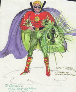
Sold2023Martin Nodell Green Lantern original art signedA large hand drawn and colored original sketch of his amed golden age creation the Green Lantern signed by him twice with COA approx 9x12 in sizeSee Sold Price
Sold2024JACK SAVITSKY, 1960 HAND COLORED DRAWINGLARGE WONDERFULLY HAND DRAWN AND COLORED PICTURE OF "JEANIE" DATED 1960 - UNFRAMED 24" X 18" Terms: PLEASE READ CAREFULLY BEFORE BIDDING. THIS SALE IS ONLINE AND IN-PERSON. PREVIEW WILL BE THURSDAY JASee Sold Price
Sold2021LATE 19TH & EARLY 20TH C. KANSAS MAPS LOT OF 6LATE 19TH & EARLY 20TH C. KANSAS MAPS LOT OF 6 Lot of late 19th and early 20th century maps of Kansas. Includes 5 Hand drawn and hand colored maps from the 1880s. Fort Scott, Eldorado, Emporia, SalinSee Sold Price
Sold2023Schoolgirl Map of the World, Hannah Edgerton, Franklin, New York dated 1828"A Map of the World Drawn by Hannah Edgerton, Cairo Seminary December 27, 1828. E. Stimson, Preceptress." These hand-drawn and colored "school girl" maps were a far more common in the boarding and finSee Sold Price
Sold2019Travels In N. America In1827-28, hand colored map, 1830Title: Travels In North America, In The Years 1827 And 1828 Provenance: IN THREE VOLUMES, 1830, with large hand colored folding map of United States and Canada showing Capt. Hall's route. [HOWES H 47]See Sold Price
50 mins LeftJasper52Large Antique French map GERMAN EMPIRE 1792 colored by POIRSON engraver Basset$170
1 day LeftJasper52An Accurate Map of the County of Kent Divided into its Lathes… by E Bowen 1762$300


![Railroad Map: Carson & Colorado Proposed 1889 Extension [170579]: Large 22"x 42" hand drawn original map on vellum map of the "Proposed Extension of the Carson & Colorado Railroad from Keeler to Mahave. The scale is four miles to the inch. The map was compiled by L.](https://p1.liveauctioneers.com/2699/299063/159201766_1_x.jpg?height=310&quality=70&version=1692045182)


![Travels In N. America In1827-28, hand colored map, 1830: Title: Travels In North America, In The Years 1827 And 1828 Provenance: IN THREE VOLUMES, 1830, with large hand colored folding map of United States and Canada showing Capt. Hall's route. [HOWES H 47]](https://p1.liveauctioneers.com/5584/144949/73283335_1_x.jpg?height=310&quality=70&version=1561753751)


