Sold2022Northern Pacific Land Grant Montana Map c. 1890Featured in this lot is this Northern Pacific land grant Montana Map circa 1890. The map features the plot map of part of Montana and reads as follows: Map Showing Northern Pacific Land Grant in partSee Sold Price
Sold2023Framed Map of Spanish & Mexican Land Grants for King RanchFramed and glazed colored map depicting the coastal area between the Rio Grande and The Nueces, showing early Spanish and Mexican land grants for King Ranch as of 1852 We happily provide seamless shiSee Sold Price
Sold2017Map of French & English Grants Lake ChamplainMap of French & English land grants on Lake Champlain. Engraved and published by Rich H Pease Albany. 22" x 14"See Sold Price
Sold2022Map of French and English Grants on Lake ChamplainFramed hand colored cadastral map of French and English land grants in the Champlain valley, names of property owners and boundaries. Engraved by Richard H. Pease (1813-1869), authored by Edmund BaileSee Sold Price
Sold20201749 Land Grant & Kearns Golden's Bridge MapsHenry Brown, Patent to 790 Acres of Land in Surry, (Sussex?) County 1749. Together with 8 renditions, 6 Edward J Kearns 1976 Map of Golden's Bridge. All numbered from the edition of 300, one signed inSee Sold Price
Sold2021Bartholomew, John 1889 Lot of 4 Maps. World etcIncl Diseases/Population, Races/Religions, Isochronic Distance/Postal Map, and British Isles - Rain/Crops/Orographical/Pasture Land. Lithograph Maps Published 1889, Cambridge for "Atlas of CommercialSee Sold Price
Sold2021Early Map of Bexar County, TXEarly map of Bexar County, TX, showing original land grants, framed frame: 30"h x 34"w Provenance: A San Antonio, TX Collection We happily provide seamless shipping services on everything we sell.See Sold Price
Sold2022[WEST FLORIDA] CHESTER, PETER. Three crudely printed land grants for West Florida, each engrossed in[WEST FLORIDA] CHESTER, PETER. Three crudely printed land grants for West Florida, each engrossed in manuscript, with an attached manuscript survey map. Pensacola, Florida, 1st September, 1777; 24 NovSee Sold Price
Sold2022[WEST FLORIDA] CHESTER, PETER. Three crudely printed land grants for West Florida, engrossed in[WEST FLORIDA] CHESTER, PETER. Three crudely printed land grants for West Florida, engrossed in manuscript, each with an attached manuscript survey map. Pensacola, Florida: 11 January, 14 November andSee Sold Price
Sold2019Antique Map US Rail Roads and Wagon Roads"Map of the Untied States showing the Limits Within Which Land Grants were Made by the Federal Government to Aid in the Construction of Railroads and Wagon Roads". Engraved and printed for the 9th CenSee Sold Price
Sold2021Royal Grant to Sir Johnson to Indian Children 1797A Map of Part of the Land in the Royal Grant Revised by Sir William Johnson to some of his Natural Indian Children Surveyed by Lawrence Vernoon 1797 Print Type: Engraving<See Sold Price
Sold20221889 LARGE WALL MAP of HOLY LAND to ILLUSTRATE BIBLE antique 52 by 60" antiqueLarge Wall Map of The Holy Land to Illustrate both the Old and New Testaments. Size 60 x 52 inches linen-backed and lacquered, wooden rollers; margins chipped, some soiling, generally sound. Made in ESee Sold Price
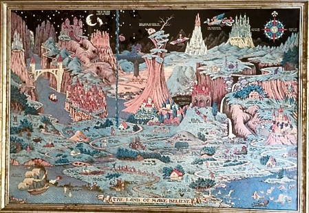
Sold2016MAP: "THE LAND OF MAKE BELIEVE", JARO HESS, 1930MAP: "THE LAND OF MAKE BELIEVE", JARO HESS, 1930Jaro Hess ( Czechoslovakia 1889-1977 ) The Land of Make Believe copyright 1930 by Jaro Hess Published by The Childs Wonderland Company, Grand Rapids MicSee Sold Price
Sold2023A Large Group of Cincinnati Land Survey MapsCourthouse survey maps of downtown Cincinnati Ohio and its wards, lot includes Cincinnati embracing its wards Part X, V, III, VI, IV, I and II; largest 42 x 22 inches. Overall good condition.See Sold Price
Sold2023Western lands assigned to the railroadsHeading: Author: (United States) Title: Place Published: Map of the United States Exhibiting the Grants of Land made by the General Government to Aid in the Construction of the Railroads and Wagon RSee Sold Price
Sold20221879 Powell Map of US with Railroad Grants -- Map of the United States Exhibiting the Grants ofTitle: 1879 Powell Map of US with Railroad Grants -- Map of the United States Exhibiting the Grants of Lands Made by the General Government to Aid the Construction of Railroads and Wagon Roads. CartogSee Sold Price
Sold2015Map: Jaro Hess "The Land of Make Believe" 1930Jaro Hess (Czechoslovakia, 1889-1977)Children's Fantasy May copyright 1930 by Jaro Hess, Grand Rapids, MIPublished by The Child's Wonderland CompanyDimension: 36" x 25"; framed: 37.7" x 26.4"ConditionSee Sold Price
Sold2020[Map] Extermination of the American BisonMap, Extermination of the American Bison by Jules Bien, circa 1889. Measures 23.75-in. x 18.375-in. G-VG/VG condition. Unframed, loose and not glued or mounted. From a non-smoking home and free of anySee Sold Price
Sold2020Lands of the Arid Region by Powell 1879 (3 Maps)Report of the Lands of the Arid Region of the United States with a More Detailed Account of the Lands of Utah by J. W. Powell. Second Edition. 1879. Government Printing Office, Washington. 195 pp. witSee Sold Price
Sold20231656 ANNE & HANNAH BRADSTREET LAND GRANT DOCUMENTAnne Bradstreet (née Dudley; March 8, 1612 – September 16, 1672) was the most prominent of early English poets of North America and first writer in England's North American colonies to be pSee Sold Price
Sold2016Benjamin Franklin signed PA Land Grant DocumentBenjamin Franklin Document Signed in ink. "B. Franklin" as president of the Supreme Executive Council of Pennsylvania. One partially-printed vellum page, 11.5 x 14.5 inches, Know Ye, That in consideraSee Sold Price
Sold2022Jefferson & Madison Signed Land Grant for Heirs of a Deceased SoldierJefferson & Madison Signed Land Grant for Heirs of a Deceased Soldier 1p partially printed of vellum, measuring 15" x 8.25", Washington, D.C., dated January 10, 1805. Signed "Th: Jefferson" and coSee Sold Price
Sold2021Thomas Jefferson and James Madison Land Grant SiThomas Jefferson and James Madison Land Grant Signed. One page, 16.25" x 9", City of Washington; October 23, 1806. One partially printed page of vellum granting a parcel of land in Ohio Territory to "See Sold Price
Sold20211808 THOMAS JEFFERSON + JAMES MADISON Land GrantAutographs 1808 President Thomas Jefferson & James Madison, as Secretary of State Signed Large Size Vellum Land Grant THOMAS JEFFERSON & JAMES MADISON. Third President of the United States (1801-1809)See Sold Price
Featured6 days LeftJasper52PACIFIC OCEAN currents British French German US Spanish colonies. LETTS 1889 map$15
May 09Hunt and Peck Estate Services, Inc.William Hole "A Description of the land of Gosen, and Moses passage though the Deserts"$50
May 09Hunt and Peck Estate Services, Inc.1867 United States General Land Office "Rapport af Chefen fur Land-Kontoret i Furenta Saterna."$200


![[WEST FLORIDA] CHESTER, PETER. Three crudely printed land grants for West Florida, each engrossed in: [WEST FLORIDA] CHESTER, PETER. Three crudely printed land grants for West Florida, each engrossed in manuscript, with an attached manuscript survey map. Pensacola, Florida, 1st September, 1777; 24 Nov](https://p1.liveauctioneers.com/292/250642/130213766_1_x.jpg?height=310&quality=70&version=1654271664)
![[WEST FLORIDA] CHESTER, PETER. Three crudely printed land grants for West Florida, engrossed in: [WEST FLORIDA] CHESTER, PETER. Three crudely printed land grants for West Florida, engrossed in manuscript, each with an attached manuscript survey map. Pensacola, Florida: 11 January, 14 November and](https://p1.liveauctioneers.com/292/250642/130213768_1_x.jpg?height=310&quality=70&version=1654271664)


![[Map] Extermination of the American Bison: Map, Extermination of the American Bison by Jules Bien, circa 1889. Measures 23.75-in. x 18.375-in. G-VG/VG condition. Unframed, loose and not glued or mounted. From a non-smoking home and free of any](https://p1.liveauctioneers.com/5755/180978/91062750_1_x.jpg?height=310&quality=70&version=1601671179)


