Sold2021Lochhead (Pub) 1811 Rare Map. World HemisphereCopper Engraved Map Published 1811 by William Lochhead, Berwick for "Modern Geography: And a Compendious General Gazetteer" Rare. Folds as issued. Paper Size: 17 x 11 inch (43 x 28cm) Some creasing. VSee Sold Price
Sold2023Lizars, Daniel 1831 LG Rare HC Map. World on Mercator's ProjectionLarge Folio Copper Engraved Map Published 1831-2 by John Hamilton, Successor to Daniel Lizars, Edinburgh for "The Edinburgh Geographical and Historical Atlas..." First Edition by Daniel Lizars. Very fSee Sold Price
Sold2020RARE world mapTitle: RARE world map Date/Period: 1596 Materials: Copperplate engraved Size: 14" x 10 1/4" Christ is shown on the left. The only world map of the century to show this. South America shows the westernSee Sold Price
Sold2018Extremely Rare world map in double HemisphereTitle/Content of Map: Extremely Rare world map in double Hemisphere projection Date: 1717 Size: 7.6x10.6†by Feuille published in 1717, Amsterdam. With California as a island. from one of the mostSee Sold Price
Sold2018Zurner: Antique Map of the World, 1700Title/Content of Map: World Map by Zurner Date Printed: c1700 Cartographer: A.F. Zurner Material/Medium: Paper Size: 20" x 21" Rare world Map. Hand colored engraved. Please note that this lot has a coSee Sold Price
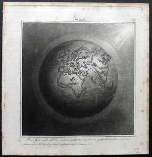
Sold2019Rhind, William 1844 Rare Map of the Old World. EarthAquatint Map Published 1844, London "The Creation: Illustrated By Six Engravings On Steel" by William Graeme Rhind. Rare. Paper Size: 6.5 x 6 inch (16.5 x 16cm) Very minor margin toning, slightly affeSee Sold Price
Sold2019Rare 1st ed. map of world diseases, c1848World map showing the spread of diseases across the globe in mid-19th century. Three inset maps show diseases in North America, the spread of cholera throughout the world and South Africa. Charts andSee Sold Price
Sold2018Bellin / la Harpe: Antique Map of the World, 1740Title/Content of Map: Rare large world Map Date Printed: 1740-1770's Cartographer: J.N. Bellin & J.F. La Harpe Material/Medium: Paper Size: 21 1/4" x 28" Copperplate engraved. From the 'Abrege de L'HiSee Sold Price
Sold2020Arrowsmith, Aaron 1825 Rare World Hemisphere Map"World on Globular Projection" Steel Engraved Map Published 1825, London for "Outlines Of The World" by Aaron Arrowsmith. Rare. Outline hand color. Paper Size: 15 x 10.5 inch (37 x 27cm) Top margin slSee Sold Price
Sold20191843 Folding Color German World Maps Europe Americas1843 Folding Color German World Maps Europe Americas Geography Austria RARE Three 19th-century world maps published in Vienna in 1843! Published for use in Austrian high schools, this atlas includes fSee Sold Price
Sold2016Rare Vintage Map of Afghanistan War Rug: 5'9'' x 7'3''Rare Vintage Afghanistan War Rug showing map of world with Afghanistan at its center from refugee camp in Peshawar, Pakistan. 1997. Size: 5'9'' x 7'3'' (175 x 221 cm). An outstanding and large exampleSee Sold Price
Sold20211970 Humbead's Revised Map Of The World PosterThis rare 1970 edition of Humbead's Map of the World was not widely distributed. It includes approximately 250 new names not in the 1969 population list including Barbi Benton, Bernie Wrightson, BilboSee Sold Price
Sold2019Rare 1st ed./1st state decorative map, 1848From the first comprehensive physical atlas of the world. This map comes from the rare first edition/first state of “Physikalischer Atlas oder Sammlung von Karten” by Heinrich Berghaus. Full titleSee Sold Price
Sold20211627 Carte de l'Amerique Corrigee, et Augmentee, dessusBy: Bertius/TavernierDate: 1627 (circa)Dimensions: 20 x 15.25 inches (50.75 x 38.5 cm)According to Burden, "This rare map is one of a set of the four known continents that Melchior Tavernier had engraSee Sold Price
Sold20231810 Modern Geography America MAP + World Map Massachusetts Elijah Parish1810 Modern Geography America MAP + World Map Massachusetts Elijah Parish Elijah Parishs “New System of Modern Geography” is an early 19th-century American geography textbook. Published inSee Sold Price
Sold20201855 Smith’s ATLAS Geography 36 BEAUTIFUL Colored MAPS1855 Smith’s ATLAS Geography 36 BEAUTIFUL Colored MAPS World ‘Smith’s Atlas of Modern and Ancient Geography’ is a collection of maps focusing on the United States, but includes maps of the worSee Sold Price
Sold2023Rare 1721 John Senex "A New Map Of The World"DESCRIPTION: Rare antique engraved map by John Senex entitled "A New Map of the World" depicting California as an island and with parts of the world still unmapped. Further featuring hand coloring, foSee Sold Price
Sold2022MAP, World, BellinWorld. Jacques Nicolas Bellin, Carte Reduite des Parties Connues du Globe Terrestre Dressee au Depost des Cartes Plans et Journaux de la Marine..., 1755 (dated). Hand Color. This is the rare first ediSee Sold Price
Sold2022Chart of the World on Mercator’s Projection, fromTitle/Content of Map: Chart of the World on Mercator’s Projection Date Printed: 1796 Cartographer: Thomas & Andrew Material/Medium: Engraving Size: 8 1/4 x 11" Description: Rare map by Isaiah ThomasSee Sold Price
Sold20191800 Geography ATLAS MAPS John Walker India Asia World1800 Geography ATLAS MAPS John Walker India Asia World Map John Walker’s ‘Elements of Geography’ is an incredibly late 18th-century English atlas known for its impressive folding maps. This atlaSee Sold Price
Sold20201836 1st ed World As It Is Perkins Slavery Indians1836 1st ed World As It Is Perkins Slavery Indians Ireland Egypt Illustrated MAP ‘The World As It Is’ was written by Samuel Perkins to give a concise view of the nations of the world as it relatesSee Sold Price
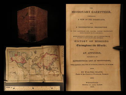
Sold20211825 1ed Missionary Gazetteer Chapin Slavery Indians1825 1ed Missionary Gazetteer Chapin Slavery Indians Illustrated Color World MAP ‘Missionary Gazetteer’ is a general history of missions throughout the world arranged alphabetically with an appendSee Sold Price
Sold201519TH & 20TH CENTURY MAPS AND BOOKS1.) 1887: With several fold out maps of the countries and a World Map: Ed. Robinson, Nugent, History of the World with all its Great Sensations Together with its Mighty and Decisive Battles and the RiSee Sold Price
Sold20211790 Geography Dictionary World MAPS Europe History1790 Geography Dictionary World MAPS Europe History French Laurence Echard Laurence Echards Geographic Dictionary is a rare, late 18th-century history of world. This book is organized much like a modeSee Sold Price
6 Lots AwayActivity AuctionsRARE >>> 8"TERRESTRIAL GLOBE/CIRCA 1870'S-80'S--- World Map Brass StandSee Sold Price
Apr 26Leland LittleAmbrosius Macrobius's Commentary on Cicero's The Dream of Scipio , with Rare Woodcut Map$125(2 bids)
May 09Hunt and Peck Estate Services, Inc.Abraham Ortelius map of Bitiurigum from Theatrum Orbis Terrarum$50
May 09Hunt and Peck Estate Services, Inc.William Hole "A Description of the land of Gosen, and Moses passage though the Deserts"$50
2 days LeftTrillium Antique Prints & Rare BooksCarey, pub. 1814 - Map of the State of South Carolina$50
2 days LeftTrillium Antique Prints & Rare BooksCarey, pub. 1814 - Map of the Missouri Territory formerly Louisiana$50
Apr 26Alexander Historical Auctions LLCCAPTURED GERMAN MAP OF ST. MIHIEL, USED BY WILLIAM J. DONOVAN$100
7 days LeftAlexander Historical Auctions LLC‘SECRET’ MAP OF OKINAWA PREPARED JUST DAYS BEFORE BATTLE$750
7 days LeftAlexander Historical Auctions LLC‘SECRET’ MAP OF OKINAWA PREPARED JUST DAYS BEFORE BATTLE$750
3 days LeftSchilb Antiquarian Rare Books1783 Captain James Cook Third Pacific Voyage Illustrated MAP Australia Rickman$215(8 bids)
3 days LeftSchilb Antiquarian Rare Books1977 JRR Tolkien 1st ed /1st printing Silmarillion Lord of the Rings + MAP$180(7 bids)


![[Maps] American Atlas, Folio (1 of 14)](https://p1.liveauctioneers.com/3532/326332/175680379_1_x.jpg?height=282&quality=70&version=1713151485)

