Sold2016Colossal statues of the Island Waihou. New Zealand.Colossal statues of the Island Waihou. New Zealand. 1835.Print of steel engraving titled „Statues colossales de l‘Ile Waihou“.Drawn by unknown.Engraved by Beyer.From „Voyage pittoresque autourSee Sold Price
Sold2020Altoon Sultan "Red Roofs, North Island, New Zealand"ALTOON SULTAN (American, 1948) "Red roofs, North Island, New Zealand," 1989, color engraving, image: 12 x 21 inches; overall (sheet/unframed): 27 x 37 inches, pencil signed lower right and dated, editSee Sold Price
Sold2016Tattoo making. New Zealand. 1837.Print of steel engraving titled „Operation du Tatouage“.Drawn by Danvin.Engraved by Chollet.From „L'univers pittoresque: histoire et description de tous les peuples“, Published by Firmin DidotSee Sold Price
Sold2023Hawaiian Group or Sandwich Islands | New Zealand | Yiti Group or Feejee Islands | Society Islands |Title: Hawaiian Group or Sandwich Islands | New Zealand | Yiti Group or Feejee Islands | Society Islands | Marquesas or Washington Is. | Galapacos Islands Publication Date: 1857 Cartographer: G. WoolwSee Sold Price
Sold20222001 CHATHAM ISLANDS NEW ZEALAND $5 COMMEMORATIVELIMITED ISSUE COLORIZED BANK NOTE. CRISP UNCSee Sold Price
Sold202220th C. Polynesian Tokelau Wood Fishing Box / TulumaSouth Pacific, Polynesia, Tokelau Island (New Zealand territory), ca. early to mid-20th century CE. A hand-carved wooden container known as a tuluma, with a lid and sennit (coconut) fiber cord. The tuSee Sold Price
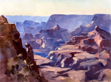
Sold2018Cedric Savage Watercolor New Zealand LandscapeCedric Savage (New Zealand, 1901 - 1969) framed and matted watercolor painting of a South Island, New Zealand landscape with buildings "Arrowtown", signed lower right, 9 1/2"h x 12"wSee Sold Price
Sold2016Map of Hawaii and New Zealand by Colton, 1855Map features: Hawaiian Group or Sandwich Islands. New Zealand. Viti Group or Feejee Islands. Society Islands. Marquesas or Washington Is. Galapagos Islands. Samoan or Navigators Island. This map is frSee Sold Price
Sold2017Rough Guide to New Zealand Big Game FishingHeading: Author: Alma Baker, C. Title: Deep Sea Big Game Fishing: Bay of Islands, New Zealand Place Published: Glasgow Publisher:Printed for Private Circulation Date Published: 1937 DeSee Sold Price
Sold2017(3) EARLY MAPS and a PRINT AFTER WILLIAM BLAKEIncluding: 1886 Fulton's Territory of Alaska, Hawaiian Group or Sandwich Islands, New Zealand, Feejee Islands, 1867 "The World in Two Hemispheres" by Mitchell (colored) and "The Day of Judgement" prinSee Sold Price
Sold2020"New Holland & Asiatic islands" Australia New ZealandTITLE/CONTENT OF MAP: 'New Holland and Asiatic islands' The top image on the right hand side shows the entire map. To view a close up of the map showing the level of printed detail, please click on thSee Sold Price
Sold2022New Holland & Asiatic islands Australia New Zealand Polynesia THOMSON 1817 mapTITLE/CONTENT OF MAP: 'New Holland and Asiatic islands' DATE PRINTED: Published in 1817. Engraved in 1814; this date is marked on the map IMAGE SIZE: Approx 52.0 x 64.0cm, 20.5 x 25.25 inches (Large);See Sold Price
Sold20211972 Cook Islands & 1965 New Zealand Proof Sets1972 Cook Islands Seven Coin Proof Set & 1965 New Zealand Seven Coin Proof SetSee Sold Price
Sold2021125th Kentucky Derby Srigraph (Peter Williams)125th Kentucky Derby Srigraph (Peter Williams). Born March 22, 1934, in Ruatoria, a small east coast village on the north island of New Zealand, Williams was brought up in the family business of raisiSee Sold Price
Sold2019New Zealand.- Society for the Diffusion of UsefulNew Zealand.- Society for the Diffusion of Useful Knowledge. The Islands of New Zealand, chart by J. & C. Walker showing the Northern and Southern islands, engraving on wove paper, sheet 410 x 340 mm.See Sold Price
Sold20231953 Her Majesties Coronation Coin and Stamp Set etc1953 Her Majesties Coronation Coin and Stamp Set, 1972 Canadian Silver Dollar, Bahama Island Silver $2, New Zealand Coin etcSee Sold Price
Sold2018Pacific OceanTitle/Content of Map: Pacific Ocean Date Printed: 1840-05-15 Cartographer: WALKER, J. & C. Size: 12.2X15.5 Details from the Aleutian Island to Australia/New Zealand and to Cape Horn/South America. DetSee Sold Price
Sold2017Mallet: Antique Map of the Solomon Islands, 1683Isles de Salomon' SOLOMON ISLANDS. Malaita Guadalcanal New Zealand Terre de Quir. Many early cartographers of the southern hemisphere believed that there was a great southern continent "Terra AustraliSee Sold Price
Sold2017Weller: Map of Pacific, Hawaii Australia New ZealandTITLE/CONTENT OF MAP: 'The Pacific Ocean'. Sandwich Islands/Hawaii Australia New Zealand This map is folding hence the centrefold line may show on the image below DATE PRINTED: 1862 IMAGE SIZE: ApproxSee Sold Price
Sold2022Binder Australia New Zealand & Pacific Island CoinsBinder Australia New Zealand & Pacific Island Coins. Approx 213 coins. 10 marked silverSee Sold Price
Sold20211969 New Zealand Cook Island Bi-Centenary Comm. Dollar1969 New Zealand Cook Island Bi-Centenary Comm. DollarSee Sold Price
Sold2016Map of New Zealand, North Island, 1902Title: Map of New Zealand, North Island Original engraving by George Cram Date: 1902 Dimensions: 11 x 14 inches No Reserve: This lot starts at $1 and has no reserve as a courtesy so that collectors caSee Sold Price
Sold2016Map of New Zealand, South Island, 1902Title: Map of New Zealand, South Island (Chatham & Tasmania) Original engraving by George Cram Date: 1902 Dimensions: 11 x 14 inches Description: Features insets of Chatham Islands & Tasmania on Van DSee Sold Price
Featured6 days LeftJasper52New Zealand Sandwich Galapagos Islands. Papuan Archipelago. Melanesia 1860 map$130
May 11Freeman's | HindmanClaes Oldenburg (American, 1929-2022) - Proposed Colossal Monument for Staten Island, New York City$9,000
6 days LeftJasper52Pacific Islands. Dusky Sound. Wallis Tonga Cook Easter Pitcairn. BONNE 1788 map$45
5 days LeftJasper52c1720 World showing Dutch East India Co possessions. CA as a island. By J.Malherbe$650
Featured5 days LeftJasper521719 Chatelain World Map -- Mappe-Monde pour Connoitre les Progres & les Conquestes les Plus$280
May 09Hunt and Peck Estate Services, Inc.1788 Henry Boswell "Historical Descriptions of New and Elegant Picturesque Views of the Antiquities$50
BonhamsNEW ENGLAND MAP. Colton's Massachusetts, Connecticut, Rhode Island. New York: G.W. & C.B. Colton...$160(19 bids)
6 days LeftDoyle New YorkThe expanded second edition of Buller's fine work on the birds of New Zealand$1,500
Crawford Family Auctions LLCTaxidermied Puffin from New Zealand on a hunk of Volcanic Rock$26(7 bids)
21 hrs LeftGuyette & Deeter, IncJohn Dilley (19th/20th century), Quogue, Long Island, New York.$4,000