Sold2016Islands, Capes and Ports in the Sea of Africa. Clouet.Isles, Caps et Ports de Mer de l'Afrique. Geographie Moderne Maker: Clouet, Jean-Baptiste Louis. Origin: Paris, 1787. Medium: Original engraving hand-colored at publication. Sheet size: 19 3/4 x 26 3/See Sold Price
Sold2021Jack & Bartholomew 1885 Mixed Lot of 21 MapsIncl Aral Sea, Cape Colony, French Ports, Alps, Algiers, Central Africa, Azores, Bristol Channel, Brazil, Borneo, Faroe Islands, Egypt, Dutch Guyana, Dublin, Fiji/Cyprus, Crimea, Belfast/Cork, ConstanSee Sold Price
Sold2024MAP, Africa, SansonWestern Africa, Cape Verde Islands. Nicolas Sanson, D'Eilanden van Capo Verde, de Kust en't Landt der Negeren..., from Algemeene Weereld-Beschryving…, 1705 (published). Hand Color. This is an attracSee Sold Price
Sold2021View of a Coastal IslandOil on canvas, with a view of a well inhabited island, showing boats, possibly depicting a rare view of Marion Island in Cape Town, South Africa (see Colonial British flags flown in the boats). 17in.See Sold Price
Sold2018Cape Verde.- Doncker (Henrick) Pas-Caart vande SouteCape Verde.- Doncker (Henrick) Pas-Caart vande Soute Eylanden ofte Ilhas de Cabo Verde, sea chart of the Cape Verde Islands, with the Island Del Fuogo's erupting volcano, with strap-work title cartoucSee Sold Price
Sold2022Follower of Thomas John BainesFollower of Thomas John Baines Follower of Thomas John Baines Port Elizabeth, South Africa from the sea; Views of Middelburg and further topographical subjects five, watercolour 12.5 x 17.5cm, unframeSee Sold Price
Sold2022WW2 Telegraphist AD Richardson Signed 35th Anniversary of the Battle of River Plate 13th Dec 1939WW2 Telegraphist AD Richardson Signed 35th Anniversary of the Battle of River Plate 13th Dec 1939 FDC. 13 of 15 Certified Copies Issued. Image shows Fairey Sea Fox. Falkland Islands Stamp with Port StSee Sold Price
Sold2015Map of Africa, 1864, Custom FramedOriginal engraving from the World Atlas by Johnson, New York, 1864. Map includes vignettes of Libera, Delta of the Nile, Cape Colony, Cape Verde Islands and St. Helena. Displayed in a wood frame and USee Sold Price
Sold2024Johnson's Africa. Colonies & tribes. Liberia Nile Delta Cape Colony 1866 mapCAPTION PRINTED BELOW PICTURE: 'Johnson's Africa // Liberia, Delta of the Nile, Cape Colony, Cape Verde Islands, and St. Helena' DATE PRINTED: 1866 IMAGE SIZE: Approx 60.5 x 45.5cm, 23.75 x 18 inchesSee Sold Price
Sold20201699 D’Eilanden van Capo Verde, de Kust en’t Landt derThis attractive antique hand-colored map features the Cape Verde Islands off the west coast of Africa, and a portion of the coast of western Africa including Muritaniya, Cape Verde, Gambia, and SenegaSee Sold Price
Sold2020United States – Florida Reefs British Admiralty ChartSmall scale and detailed sea chart of the Florida Reefs with Key West and the former rail road over the islands. Tidal information is mentioned for the most important ports. Authentic, very detailed sSee Sold Price
Sold2020A Chinese Export Oil on Canvas PaintingA Chinese Export Oil on Canvas Painting depicted a port in South China with trading boats on the sea and an island with pogoda. Height of image 19 1/4 x length 23 1/2 in., 48.9 x 59.7 cm.See Sold Price
Sold2021GOOS, PIETER - Caribbean Islands Sea Chart 1666GOOS, Pieter (1616-1675) . Pascaert Vande Caribes Eylanden. Amsterdam: 1666. Engraved sea chart, period hand-colouring in outline. Sheet size: 21 1/2 x 25 inches. Minor age toning. Fine seventeenth ceSee Sold Price
Sold2022Important Nassau Islands Port by the watercolor master Dong Kingman. Signed watercolor on paper.Important Nassau Islands Port by the watercolor master Dong Kingman. Signed watercolor on paper. Measures 23.5 Inches High x 30.5 Inches Wide. Framed. Good condition, no apparent damages. Provenance HSee Sold Price
Sold2017Moll - Correct Map of the Whole World, 1719Herman Moll (1654?-1732), cartographer and publisher A New & Correct Map of the Whole World Shewing y.e Situation of its Principal Parts. Viz the Oceans, Kingdoms, Rivers, Capes, Ports, Mountains, WooSee Sold Price
Sold2021Slavery Broadside: “Gang of 25 Sea Island CottonSLAVERY. Broadside, “Gang of 25 Sea Island Cotton and Rice Negroes”, 1 p., September 25, 1852, Charleston, 7” x 9.25”. Wrinkles, abrasion to portions of some text, tape repairSee Sold Price
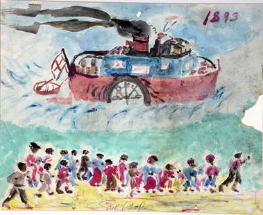
Sold2021Sam Doyle. Red Cross Boat To Sea Island.Sam Doyle. The Red Cross Boat Responding To the Sea Island Hurricane of 1893. Signed. Watercolor and graphite on found paper. Minor foxing and loss at middle right, otherwise great environmental condiSee Sold Price
Sold2022WYNDELL TAYLOR, CLOISTER AT SEA ISLAND WATERCOLORWyndell Taylor (American/Georgia, 1928-1992). "The Cloister at Sea Island", watercolor. Signed lower left; framed. Approx. 27.25" x 33.25" (frame), 17" x 23" (sight)See Sold Price
Sold2022French Sea Port Oil Painting after Eugene BoudinOil painting on canvas after Eugene Louis Boudin (1824-1898). French European harbor scene seascape with fishing boats, dock structures and anchored fleet ships along the horizon. Titled "The Port ofSee Sold Price
Sold2021Album different bank notes various countries SThe album contains various banknotes from Solomon Islands, South Africa, Somalia, Somaliland, Spain, Sudan, Swaziland, Sweden. Sweden: 1x 1,000 kronor. 1984. uncirculated. In near mint condition. 1x 1See Sold Price
Sold2021Claude Conover (OH, 1907-1994) TUCUB, Ceramic StoolProperty from a Private Collection, Sea Island, GA Description: Claude Conover (Ohio, 1907 - 1994) TUCUB, Ceramic Stool, of circular form, signed 'Claude Conover' and titled 'TUCUB' on base, overaSee Sold Price
Sold2022Two 18K Gold Necklaces and One 14K Gold NecklaceProperty from a Private Collection, Sea Island, GA Description: Two 18K Gold Necklaces and One 14K Gold Necklace, comprising a 17 in. 18K gold wide chain necklace marked 'Italy, 18Kt' on clasp, aSee Sold Price
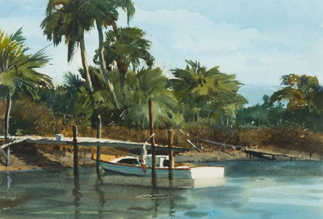
Sold2019Ogden Minton Pleissner (American, 1905-1983) FishingOgden Minton Pleissner (American, 1905-1983) Fishing Boat, Sea Island, Georgia watercolor on paper signed Pleissner (lower left); titled (verso) 9 1/2 x 6 1/4 inches. Provenance: Lapham & Dibble GalleSee Sold Price
Sold2021Seven Limoges Trinket Boxes Relating to ChristmasSeven Limoges Trinket Boxes Relating to Christmasfour with Santa Claus (largest 4 1/2 in.); a tree (4 1/2 in.); a sled; a boot; a nutcracker. Private Collection, Sea Island, Georgia Additional high-reSee Sold Price
Featured15 hrs LeftJasper52Antique sea 'Chart of the Islands of Cape Verd' [Verde]. MOUNT & PAGE 1758 map$260
1 day LeftForum AuctionsBritain.- Railways Handkerchief (1850s) The Railways in Great Britain, Also the Line of Navigation£40(1 bid)
2 days LeftAlexander Historical Auctions LLCSHOLTO DOUGLAS (A. W. BEAUCHAMP-PROCTOR COMBAT REPORT)$100
15 hrs LeftJasper52Bermuda Islands, North Atlantic Ocean. ADMIRALTY sea chart 1946 (1950) old map$360
15 hrs LeftJasper52Hawaiian or Sandwich Islands North Pacific Ocean ADMIRALTY chart 1881 (1955) map$360
5 days LeftClaydon Auctioneers LtdLouis Dupre (1789-1837), Original lithograph hand coloured with watercolour, Titled Grec d'Hidra -£300
May 05Tremont Auctions1848 British school "Kalk Bay" Cape Town, South Africa watercolor landscape painting depicting the$150


![Antique sea 'Chart of the Islands of Cape Verd' [Verde]. MOUNT & PAGE 1758 map (1 of 1)](https://p1.liveauctioneers.com/5584/326140/175576839_1_x.jpg?height=282&quality=70&version=1713288521)


![Hugo, Pieter; Looking Aside [2006 1ST EDITION & 1ST PRINTING - FINE COPY] (1 of 4)](https://p1.liveauctioneers.com/8658/325945/175541346_1_x.jpg?height=282&quality=70&version=1712964944)
