Sold2016Map of New Zealand, South Island, 1902Title: Map of New Zealand, South Island (Chatham & Tasmania) Original engraving by George Cram Date: 1902 Dimensions: 11 x 14 inches Description: Features insets of Chatham Islands & Tasmania on Van DSee Sold Price
Sold2019Bryce, James 1881 Map of New Zealand South IslandLithograph Map Published 1881, London for ""The International Atlas and Geography..." by James Bryce. Maps by Edward Weller & John Bartholomew. Uncommon. Paper Size: 18 x 13 inch (46 x 33cm) Good CondSee Sold Price
Sold2016Map of New Zealand, North Island, 1902Title: Map of New Zealand, North Island Original engraving by George Cram Date: 1902 Dimensions: 11 x 14 inches No Reserve: This lot starts at $1 and has no reserve as a courtesy so that collectors caSee Sold Price
Sold2020NEW ZEALAND. Shows NZ Company settlements in 1851.TITLE/CONTENT OF MAP: 'New Zealand' Vignettes: Auckland; Mount Egmont from New Plymouth; Wellington. North Island is indicated as "New Ulster or North Island"; the island known today as South Island iSee Sold Price
Sold2024James Cook - Map / Chart Of The Island TahitiEngraved nautical map from the 1774 first French edition of the first map of New Zealand, illustrating Lieutenant James Cook's 1769 exploration of the passage between New Zealand's North and South islSee Sold Price
Sold2024James Cook - Map of Tahiti, the Society Islands, and the VicinityEngraved nautical map from the 1774 first French edition of the first map of New Zealand, illustrating Lieutenant James Cook's 1769 exploration of the passage between New Zealand's North and South islSee Sold Price
Sold2018Pacific OceanTitle/Content of Map: Pacific Ocean Date Printed: 1840-05-15 Cartographer: WALKER, J. & C. Size: 12.2X15.5 Details from the Aleutian Island to Australia/New Zealand and to Cape Horn/South America. DetSee Sold Price
Sold2017Map of New South Wales, 1902Map: New South Wales, 1902 Original engraving from Pictoral Atlas of the World by George Cram, 1902. Dimensions: 11 3/4" x 14 1/2" Please note that this lot has a confidential reserve. When you leaveSee Sold Price
Sold2019Bryce, James 1881 Map of New Zealand North IslandLithograph Map Published 1881, London for ""The International Atlas and Geography..." by James Bryce. Maps by Edward Weller & John Bartholomew. Uncommon. Paper Size: 18 x 13 inch (46 x 33cm) Good CondSee Sold Price
Sold2022Antique Map of Oceania - Map of New Zealand - North Island - John BartholomewAntique map by John Bartholomew & Co for The Edinburgh Geographical Institute. Large chromolithographed map. Technique: Chromolithography. Date: 1880. Artist: John George Bartholomew and Son. Place: ESee Sold Price
Sold2016Reinecke: Australia/ New Zealand/ Hawaii Map 1804Map: Australia/ New Zealand/ Hawaii/ South Pacific "General Charte von Australien" Publishing: Reinecke, Johann Matthias: Weimar Date: 1804 Size: 17.75 x 24 inches An uncommon map described by TooleySee Sold Price
Sold20191855 Colton Map of Hawaii, New Zealand, Oceania IslandsTitle/Content of Map: 1855 Colton Map of Hawaii, New Zealand, Oceania Islands -- Hawaii or Sandwitch Islands [with] Samoan.. [with] New Zealand [with] Viti Group or Feejee Islands [with] Societi IslanSee Sold Price
Sold2018Cedric Savage Watercolor New Zealand LandscapeCedric Savage (New Zealand, 1901 - 1969) framed and matted watercolor painting of a South Island, New Zealand landscape with buildings "Arrowtown", signed lower right, 9 1/2"h x 12"wSee Sold Price
Sold2023New Zealand Silver Pocket Watch (19th Century)Hokitika (South Island) marked pocket watch. Inscribed and dated 1874. Provenance: Providence, Rhode Island estate.See Sold Price
Sold2020Bartholomew, John 1922 Pair Maps. New Zealand & Pacific"New Zealand" and "Islands of Oceania" The latter showing Hawaii and other Pacific Islands. Large Lithograph Maps Published 1922 by The Times, London for "The Times Survey Atlas of the World" Maps bySee Sold Price
Sold2017Weller: Map of Pacific, Hawaii Australia New ZealandTITLE/CONTENT OF MAP: 'The Pacific Ocean'. Sandwich Islands/Hawaii Australia New Zealand This map is folding hence the centrefold line may show on the image below DATE PRINTED: 1862 IMAGE SIZE: ApproxSee Sold Price
Sold2016New South Wales Australia 1814Heading: (Map) Author: Carey, Mathew Title: A New and Accurate Map of New South Wales with Norfolk and Lord Howe's Islands, Port Jackson &c. from Actual Surveys Place Published: Philadelphia PublisherSee Sold Price
Sold2022New Holland & Asiatic islands Australia New Zealand Polynesia THOMSON 1817 mapTITLE/CONTENT OF MAP: 'New Holland and Asiatic islands' DATE PRINTED: Published in 1817. Engraved in 1814; this date is marked on the map IMAGE SIZE: Approx 52.0 x 64.0cm, 20.5 x 25.25 inches (Large);See Sold Price
Sold2023New Zealand Sandwich Galapagos Islands. Papuan Archipelago. Melanesia 1859 mapNew Zealand. // Sandwich Islands, or Hawaiian Group, // Galapagos Islands // Papuan Archipelago' by John Bartholomew (1859). Antique engraved atlas map with original hand colour/color, 37.0 x 53.5cm,See Sold Price
Sold2017(3) EARLY MAPS and a PRINT AFTER WILLIAM BLAKEIncluding: 1886 Fulton's Territory of Alaska, Hawaiian Group or Sandwich Islands, New Zealand, Feejee Islands, 1867 "The World in Two Hemispheres" by Mitchell (colored) and "The Day of Judgement" prinSee Sold Price
Sold2016Map of Hawaii and New Zealand by Colton, 1855Map features: Hawaiian Group or Sandwich Islands. New Zealand. Viti Group or Feejee Islands. Society Islands. Marquesas or Washington Is. Galapagos Islands. Samoan or Navigators Island. This map is frSee Sold Price
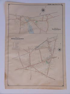
Sold2016Bridgehampton & Watermill, Long Island, 1902Original engraving published by E. Belcher Hyde from "Atlas of Suffolk County, Long Island, New York," Philadelphia, 1902. Map features family names, historic buildings and railroad routes. DimensionsSee Sold Price
Sold2019LARGE LOT WORLD COINS & STAMPSLarge Lot of World Coins and Stamps. Includes Proof sets for Cayman Islands, 1983 Canada, 1967 New Zealand. 1969 New Zealand, 1983 South Africa, 1984 South Africa, 1979 Malta, 1972 Cook Islands, 1971See Sold Price
Sold2019Keulemans Birds of New Zealand LithographKEULEMANS, Johannes (1842-1912). Turnagra Hectori / Turnagra Crassirostris (South and North Island Piopio). Lithograph with original hand color from Buller's History of the Birds of New Zealand. LondoSee Sold Price
Featured6 days LeftJasper52Océanique Partie de la Nle Zélande 60 New Zealand South Is VANDERMAELEN 1827 map$280
2 days LeftSchilb Antiquarian Rare Books1783 Captain James Cook Third Pacific Voyage Illustrated MAP Australia Rickman$215(8 bids)
6 days LeftJasper52Océanique Partie de la Nle Zélande 59 New Zealand North Is VANDERMAELEN 1827 map$260
6 days LeftJasper52A plan of the operations of the King's army… in New York… FADEN/STEDMAN 1794 map$6,500
6 days LeftJasper52Carte de la Nouvelle Zéelande. New Zealand. Cook Strait. Thames. BONNE 1788 map$340
6 days LeftJasper52New Holland & Asiatic islands Australia New Zealand Melanesia THOMSON 1817 map$300
6 days LeftJasper52MALAY ARCHIPELAGO/EAST INDIA ISLANDS. Philippines Indies. RAPKIN/TALLIS 1851 map$260
4 days LeftJasper521839 Stiles, Sherman and Smith Map of Mid-Atlantic States -- Map of the Middle States Designed to$50
Apr 29Claydon Auctioneers LtdBook: A 1911 hand illuminated Royal Exchange Assurance Presentation Volume containing illuminated£200
6 days LeftJasper52Océanique. Partie… Nlle Galles du Sud #55. New South Wales VANDERMAELEN 1827 map$300
6 days LeftJasper52Map of the Wharf Accommodation of the Port of Sydney. Harbour Commissioners 1919$1,300
May 10Rail & Road AuctionsTen Air New Zealand Airline Playing Card Decks - TEAL, 30th Anniversary, 50th Anniversary, and More$20
6 days LeftJasper52AUSTRALIA.Sydney view.Pre-Queensland (est 1859).Counties.TALLIS/RAPKIN 1849 map$260
6 days LeftJasper52Océanique. Partie… Nle Hollande #51. Queensland NSW coast. VANDERMAELEN 1827 map$300


![1855 Colton Map of Hawaii, New Zealand, Oceania Islands: Title/Content of Map: 1855 Colton Map of Hawaii, New Zealand, Oceania Islands -- Hawaii or Sandwitch Islands [with] Samoan.. [with] New Zealand [with] Viti Group or Feejee Islands [with] Societi Islan](https://p1.liveauctioneers.com/5584/157856/79675033_1_x.jpg?height=310&quality=70&version=1577197209)