Sold2018Antique Hand Colored Maps of The AmericasAntique Hand Colored Maps of The Americas. This lot features two 19th century hand colored maps of North America and South America from the Carey and Lee Atlas American Edition 1823-24. Both maps areSee Sold Price
Sold2022Reproduction of 18th Century North America MapReproduction of 18th Century North America Map This map is a 20th century hand-colored lithographic reproduction of a 17th century map of the colonial territories held by Spain, England, and France. TSee Sold Price
Sold2017Morisot: Antique Map of North America, 1643Title: Americae Septentrionalis Circuitus. Mid-17th century French copperplate map with cartographic myths Map maker: Claude Bartholomy Morisot Place and Year: Dijon, 1643 Dimensions: 16.6 x 13.5 cm (See Sold Price
Sold2021Lot of 12 Early 19th Century MapsMostly by Jeffery's. Depicting the East Indies, Germany and surround, Asia, Africa, "Turky in Asia" , Italy and surround, Spain & Portugal, early North America, France, South America, Europe, and HungSee Sold Price
Sold20184 19th Century Maps The World, North/South U.S.4 19th Century Maps The World, North South U.S.. 4 Maps of The World, Political Map of The Southern Division of the U.S., The Northern Division of the U.S. and Political Map of South America and AfricSee Sold Price
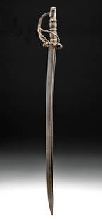
Sold202117th C. Spanish Colonial Iron & Wood Espada AnchaWestern Europe or North America, Spain or Mexico, Spanish Colonial Period, ca. 17th century CE. A lovely example of a forged-iron sword known as an espada ancha (literally "wide sword") with a lathe-tSee Sold Price
Sold2023Three 19th Century MapsAn English hand colored map of North American, a hand colored map of South America dated 1839 by Samuel Augustus Mitchell and a hand drawn and colored map of South America. All framed. Dimensions:TheSee Sold Price
Sold2021Large 17th C. Colonial Spanish Wood Chest w/ Iron LockNorth America, Mexico, Spanish Colonial Period, ca. 17th to 18th century CE. A lovely chest composed of four lateral walls, a base made from multiple wooden slats, and a form-fitting lid that featuresSee Sold Price
Sold2017Pr Bead Strands - Nueva Cadiz, Venetian & Pre-Columbian**First Time At Auction**North or South America, Nueva Cadiz, ca. 1600 to 1800 CE. A lovely strand of sixteen Nueva Cadiz blue glass beads named for a 16th century Spanish colony in Venezuela where arSee Sold Price
Sold202020th C. Peruvian Silver Bracelets & Mexican Ashtray**Originally Listed At $150** North America, Mexico, ca. 20th century CE; South America, Peru, ca. 20th century CE. A lovely trio of vintage Latin American silver-paneled jewelry pieces, including twoSee Sold Price
Sold201820th C. Vintage Latin American Silver Choker & Bracelet**Originally Listed At $125** North America, Mexico, ca. mid 20th century CE; South America, Peru, ca. mid 20th century CE. A lovely pair of vintage Latin American silver-paneled jewelry pieces. FirstSee Sold Price
Sold2019Rare 1st ed. map of world diseases, c1848World map showing the spread of diseases across the globe in mid-19th century. Three inset maps show diseases in North America, the spread of cholera throughout the world and South Africa. Charts andSee Sold Price
Sold2016Pair of Pottery Bowls, Nazca and HopiPre-Columbian, South Coast Peru, Nazca, ca. 250 BCE to 125 CE and North America, Southwest, Hopi, ca. early 20th century CE. A lovely pair of ceramic bowls, one from the Nazca culture of ancient Peru,See Sold Price
Sold2022JOHN SPEED 17TH C. MAP, AMERICA.John Speed map of the Americas, engraved with hand coloring, bordered on three sides with depictions of native peoples from Florida, Virginia, New England, and with city views including Havana, Cuzco,See Sold Price
Sold2022Antique 16th Century Map South AmericaTitle: Antique 16th Century Map South America Description:Antique 16th Century Map South America Circa Date: 1598 Condition of piece: Map displays toning, some water stains, wrinkles and creases,See Sold Price
Sold2023Five Antique Maps, North & South AmericaDescription: Five antique maps including a 1834 Charles Bowen mapof the Great American Eclipse, an unattributed 1825 map of New England, an 1834 Graf & Sorel map of Nunavut, Canada from the exploratioSee Sold Price
Sold2023Beeton, Samuel 1868 Pair of Maps. North & South AmericaLithograph Maps Published 1868, London for "Beeton’s Dictionary Of Geography" by Samuel Orchart Beeton. Folds as issued. Paper Size: 10 x 8 inch (26 x 20cm) Good ConditionSee Sold Price
Sold20221765 Atlas Map of North + South AMERICA, ExpillyHistoric Maps 1765 Atlas Map of North and South AMERICA by Expilly 1765 Copper Engraved Atlas Map of North and South AMERICA titled, "AMERIQUE Septentrionale et Meridionale," from Le Geographe ManuelSee Sold Price
Sold2019Blaeu map of North & South AmericaHeading: Author: Blaeu, Willem Title: Americae Nova Tabula Place Published: Amsterdam Publisher: Date Published: c.1633 Description: Copper-engraved map. 36x46.5 (14¼x18¼")See Sold Price
Sold2023Eighteenth Century Map of North AmericaMap titled "NORTH AMERICA wherein are particularly distinguished the British Dominions, the United States, and the adjacent Spanish territories" by Thomas Kitchin and published by Laurie & Whittle, NoSee Sold Price
Sold2017Map of North & South America, 1805Charte von America. By von J. Walch, Augsburg. 1805. Size with Margin: 56 x 65 cm Please note that this lot has a confidential reserve. When you leave a bid in advance of the auction, submit your maxiSee Sold Price
Sold2017Ortelius: Antique Map of North & South America, 1598Map: America sive Novus Orbis Date Printed: 1598 Cartographer: Abraham Ortelius Size: 4 x 3 Condition: Good condition. A few brown thumbprints and one repaired marginal tear at the Northwest coast ofSee Sold Price
Sold2017Homann Heirs: Antique Map of North & South America 1746Title/Content of Map: Americae mappa generalis Date Printed: 1746 Cartographer: Homann Heirs Material/Medium: Paper Size: 23 1/2" x 21" Hand colored copperplate engraved. Published in Nuremberg. Map hSee Sold Price
Sold2017Buchon: Antique Map of North & South America, 1825Title/Content of Map: 'Carte géographique, statistique et historique de l'Amerique' The North American map shows Mexico with its borders prior to the Mexican-American war, with its territory includinSee Sold Price
May 10New England Auctions - Fred GiampietroPair of Stately 17th Century English Stone Urn Finials$550(2 bids)
15 hrs LeftTemplum Fine Art AuctionsBeautiful New Spanish Colonial Virgin of Bethlehem, Mexico, late 17th C to early 18th Century€2,250
May 10New England Auctions - Fred GiampietroPair of York and Lancaster Bas-Relief Carvings$125(2 bids)


![[Shelf-Lot, Bindings, Various] (1 of 6)](https://p1.liveauctioneers.com/3532/326332/175680480_1_x.jpg?height=282&quality=70&version=1713150771)