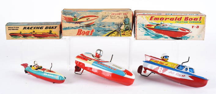
Sold2019Lot of 3: Tin Litho Crank Wind Up Speed Boats.The first is a rare tin litho, crank wind up Sea Gull Racing Boat, Japan, Marusan. Futuristic racing boat, marked "2" working, near mint, 7-1/2". Includes original box, near mint. The second is an EmeSee Sold Price
Sold2020United States, East Coast – Forida Street BritishUnused, very detailed sea chart of the Florida coasts with Miami, Cape Kennedy, the Bahama Banks and so on. The first surveys are from 1898 from Admiralty surveys. Authentic, very detailed sea chart,See Sold Price
Sold2023Gheyn - Pistris or Sea Monsters, Dragon, Celestial ChartThis constellation engraving is from Jakob van Gheyn's Arataea sive signa coelestia after the work of the ancient astrological pet Aratus (315-240 BCE). This first edition of the work was published inSee Sold Price
Sold2021Scarce h/c timeline chart of U. S., 1821200-year-old, hand colored antique and rare timeline of the history of the United States, from the first settlement in Jamestown to James Monroe's inauguration in 1821. Chronological and Statistical MSee Sold Price
Sold2021Scarce h/c timeline chart of U. S., 1821Title: Scarce h/c timeline chart of U. S., 1821 Description: 200-year-old, hand colored antique and rare timeline of the history of the United States, from the first settlement in Jamestown to James MSee Sold Price
Sold2020Japan. Seto inner sea.Japan. Seto inner sea.XIXth century, [Edo period]Manuscript nautical chart, mm. 3300 x 5750. Very rare commercial nautical chart engraved on wood with the commercial nautical routes highlighted in redSee Sold Price
Sold2022Dudley Sea Chart of DenmarkDUDLEY, Sir Robert (1574-1649). [Denmark] Carta particolare che comincia con il gran fiume Albis e contene parte dell mare Baltico e Ientrata al sondo di Danemarca... Engraved map. Florence, 1646.20 7See Sold Price
Sold2022Dudley Sea Chart of ArgentinaDUDLEY, Sir Robert (1574-1649). [Argentina] Carta particolare della costa di America Australe che comincia al C. di Matas sin al C. di Galegos. Engraved map. Florence, 1646. 20 7/8" x 16 1/8" sheet. SSee Sold Price
Sold2022Dudley Sea Chart of PortugalDUDLEY, Sir Robert (1574-1649). [Portugal] Carta Particolare Del Oceano Che Comincia Con il Capo S. Vincentio E Finisco Con Il Capo Roxo in PortogalloEngraved map. Florence, 1646. 20 7/8" x 17" sheet.See Sold Price
Sold2022Dudley Sea Chart of Western FranceDUDLEY, Sir Robert (1574-1649). [France] Carta particolare della costa di Guasconnia in Francia che comincia con il Fiuime di Burdeaux e Finisce con l'Isola di Heys. Engraved map. Florence, 1646. 20 7See Sold Price
Sold2018Lootsman / Jacobsz: Antique Sea Chart of Brazil, 1662Title/Content of Map: Pascaerte van Brasil van Rio de Maranhaon tot Rio de la Plata . . . Date Printed: 1662 Cartographer: Lootsman/Jacobsz Size: 21.5" x 16.5" Rare sea chart of Brazil, one of the earSee Sold Price
Sold2017Carre: Map of Sea of Japan & Korea, 1883Map: 'Carte des iles et mers du Japon, d'après les documents les plus récents' A large 19th century French sea chart of Japan, the sea of Japan, and the adjacent coast of north east Asia including tSee Sold Price
Sold2021Texas. A very important and rare first state firstTitle: Texas. A very important and rare first state first edition map. 1850 by Thomas. Date/Period: c1850 Size: 16 1/2 x 13 1/2 inches. Material: Hand colored steel engraved Description: A very importSee Sold Price
Sold2018Kawase, Hasui. Evening at Soemoncho, Osaka At Evening.Kawase, Hasui (Japanese, 1883—1957). Evening at Soemoncho, Osaka At Evening. Japan, 1933. First-state woodblock print, from Collection of Scenic Views of Japan II. 15 1/2 x 10 1/8". Fine.See Sold Price
Sold20231947 1st ed TARZAN and The Foreign Legion Edgar Rice Burroughs World War II Japan1947 1st ed TARZAN and The Foreign Legion Edgar Rice Burroughs World War II Japan A rare, first edition printing of the 22nd title in the iconic Tarzan series, Tarzan and the Foreign Legion. Tarzan isSee Sold Price
Sold20237 Early Tennessee Geological Reports, incl. 3 TN Maps & author Troost inscribedSeven (7) Tennessee geological survey reports including 4 by Gerard Troost (Netherlands/Tennessee, 1776-1850), first State Geologist, with three rare 1840 Tennessee maps. 1st item: FIFTH GEOLOGICAL RESee Sold Price
Sold20231947 TARZAN 1st ed The Foreign Legion Edgar Rice Burroughs World War II Japan1947 TARZAN 1st ed The Foreign Legion Edgar Rice Burroughs World War II Japan A rare, first edition printing of the 22nd title in the iconic Tarzan series, Tarzan and the Foreign Legion. Tarzan is oneSee Sold Price
Sold20191794 Sea Chart of South Part Sumatra 18th Century Mapa very rare 18th century antique sea chart. This is an uncolored copper plate engraving. Image measures 24\" x 32.5\". This map has been matted and is ready for framing. A stunning chart of the southeSee Sold Price
Sold2020Nautical Map / Sea Chart, #1212 Eastern Long IslandDescription: Nautical Map / Sea Chart, United States East Coast, Connecticut - New York, Long Island Sound, Eastern Part, 12th edition feb 10 / 69 ; all measurements are approximate; Folded; ShippingSee Sold Price
Sold2020Nautical Map / Sea Chart, #1211 MarthaDescription: Nautical Map / Sea Chart, United States East Coast, Rhode Island - Connecticut - New York, Block Island Sound and Approaces9th edition, dec 23/63 stamped CORRECTED ONLY FOR AIDS & HAZARDSSee Sold Price
Sold2021Nautical Map / Sea Chart, #362 Block Island Sound andDescription: Nautical Map / Sea Chart, United States East Coast, New York, Long Island, Block Island Sound and Gardiner's Bay, 6th edition, Feb 10/69; Shipping: $20; different rate to California, AlasSee Sold Price
Sold2017First state of this handsome sailing chart of The GulfA Chart of the Gulf of St. Laurence...Thomas Jefferys (c. 1719 – 1771). Copperplate engraved map. London: Sayer & Bennett, 1775. 21 1/2 x 29 inches sheet. First state of this handsome sailing chartSee Sold Price
Sold2022MAP, Lesser Antilles, DelisleLesser Antilles. Guillaume Delisle, Carte des Antilles Francoises et des Isles Voisines Dressee sur les Memoires Manuscrits..., 1717 (dated). Hand Color. This beautiful chart is the first state of DelSee Sold Price
Sold2019Rare 1st ed./1st state decorative map, 1848From the first comprehensive physical atlas of the world. This map comes from the rare first edition/first state of “Physikalischer Atlas oder Sammlung von Karten” by Heinrich Berghaus. Full titleSee Sold Price
May 01Michael Scarola Rare and Used BooksState And Diplomacy Early Modern Japan By Ronald P. Toby SIGNED First Edition$20
May 09Hunt and Peck Estate Services, Inc.1836 Paris M. Davis 1st "An Authentic History of the Late War Between the United States and Great$50
7 days LeftDoyle New YorkThe 1787 Constitution of the Pennsylvania Society for Promoting the Abolition of Slavery$1,000
May 01Michael Scarola Rare and Used BooksThe Life And Adventures Of Nicholas Nickleby By Charles Dickens First Edition Second State$200
May 01Michael Scarola Rare and Used BooksBetween Sea And Sky Landscapes Of Long Island's North Fork By Jake Rajs SIGNED First Edition$25


![Japan. Seto inner sea.: Japan. Seto inner sea.XIXth century, [Edo period]Manuscript nautical chart, mm. 3300 x 5750. Very rare commercial nautical chart engraved on wood with the commercial nautical routes highlighted in red](https://p1.liveauctioneers.com/3336/174968/90450870_1_x.jpg?height=310&quality=70&version=1600527463)
![Dudley Sea Chart of Denmark: DUDLEY, Sir Robert (1574-1649). [Denmark] Carta particolare che comincia con il gran fiume Albis e contene parte dell mare Baltico e Ientrata al sondo di Danemarca... Engraved map. Florence, 1646.20 7](https://p1.liveauctioneers.com/1968/250616/130196505_1_x.jpg?height=310&quality=70&version=1654190895)
![Dudley Sea Chart of Argentina: DUDLEY, Sir Robert (1574-1649). [Argentina] Carta particolare della costa di America Australe che comincia al C. di Matas sin al C. di Galegos. Engraved map. Florence, 1646. 20 7/8" x 16 1/8" sheet. S](https://p1.liveauctioneers.com/1968/250616/130196501_1_x.jpg?height=310&quality=70&version=1654190895)
![Dudley Sea Chart of Portugal: DUDLEY, Sir Robert (1574-1649). [Portugal] Carta Particolare Del Oceano Che Comincia Con il Capo S. Vincentio E Finisco Con Il Capo Roxo in PortogalloEngraved map. Florence, 1646. 20 7/8" x 17" sheet.](https://p1.liveauctioneers.com/1968/250616/130196507_1_x.jpg?height=310&quality=70&version=1654190895)
![Dudley Sea Chart of Western France: DUDLEY, Sir Robert (1574-1649). [France] Carta particolare della costa di Guasconnia in Francia che comincia con il Fiuime di Burdeaux e Finisce con l'Isola di Heys. Engraved map. Florence, 1646. 20 7](https://p1.liveauctioneers.com/1968/250616/130196506_1_x.jpg?height=310&quality=70&version=1654190895)


![[Colonial North Carolina Document] (1 of 2)](https://p1.liveauctioneers.com/3532/326332/175680477_1_x.jpg?height=282&quality=70&version=1713150771)


