Sold2018US Army 43 INFANTRY Division LUZON Report 1945Report with pictures January 1945Pages are marked SECRET,but I think the secret is out that was 1945. Armored vehicles of photos marked confidential in sequence order. Maps. This explains the completeSee Sold Price
Sold2022Antique Japanese MapAntique Japanese Map, Marked Ishi-Kawa-Ryugi, Genroku Yonen-Ban-Nippon-zu, Tokyo, Sagamiya, 1691, Maps Of Japan. Folded Approximately 10.375L x 7.0625W in. Unfolded Approximately 66L x 40.25W in.See Sold Price
Sold20171858 Berkshire Massachusetts Map1858 Berkshire Massachusetts map. Marked and dated "Henry R. Walling/1858". Frame overall 64" x 65".See Sold Price
Sold202219th c. Hand Drawn Map19th c. hand drawn map. Marked "A / MAP / OF THE / UNITED STATES / DRAWN / BY / LEONARD ATWATER / MARCH 1824". Sight 15 3/4" x 19 1/2", overall 19" x 22 1/2".See Sold Price
Sold2023Vintage Framed Map of Paris1957 Blondel La Rougery Paris Map. Marked Plan De Paris A Vol D'Oiseau, Blondel La Rougery, Edit. Imp. 7, Rue Saint Lazare Paris 9e, Dressee Et Imprimee Par Blondel La Rougery, tous droits d reproductSee Sold Price
Sold2020VINTAGE FRAMED FLORIDA TAPESTRY MAPFramed Florida tapestry original linen textile map. Marked Davisco lower right. Measures 44.5" x 37" w/ frame.See Sold Price
Sold20231872 Pianta Della Citta Di Firenze (City of Florence) Map LithographDESCRIPTION: Pianta Della Citta Di Firenze (Plan of the City of Florence) Map of Florence Italy. Each segment backed by canvas. Map marked: "E.E. Oblieghi e V. Romanelli editori proprietari" (Lower MiSee Sold Price
Sold2017Rare 1967 Mouzon Map of North & South Carolinavery limited production by Louis and Clark Explorer Maps LLC in Kitty Hawk, and Charlotte, North Carolina. reproduction gives excellent detail and very well resembles the original map. marked "L&C" atSee Sold Price
Sold2023Rare 1881 New York City Elevated Railway Map1881 New York City Elevated Rail Roads Map. Marked "The City Of New York South Of 155th St. Showing The Constructed Lines Of Elevated Railroad April 1881. Plate VIII Trans. Am Soc. Civ. Eng'r's VOL.X.See Sold Price
Sold2023Three Civil War Albumen CDV PhotographsDescription: Three Civil War Albumen CDV Photographs, the first of General William Rosecrans with spyglass and map, marked 'Published by E. Anthony, 501 Broadway, N.Y.' on verso' (3 3/4 in. x 2 1See Sold Price
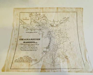
Sold2024Charleston Harbour map- Blunt 1833 mapCharleston Harbour map marked from New York published by E and G W. Blunt 1833. Engraved by William HookerSee Sold Price
SoldRare secret WW2 German aircraft flying instructionsOne page. Marked SECRET. Probably from the manual. These pages were presumably given to POWs to facilitate escape via plane.See Sold Price
Sold20231906 Geological Survey Map of New Jerseymap marked revised 1906, torn and worn at top left hand corner, some spots throughout, frame worn and aged, 38" tall X 28 1/2" wideSee Sold Price
Sold2023County Of Leitrim Topographic Map SerigraphTopographic map marked on left corner County of Leitrim. County Leitrim is a county in Ireland. It is in the province of Connacht and is part of the Northern and Western Region. Topographic map also hSee Sold Price
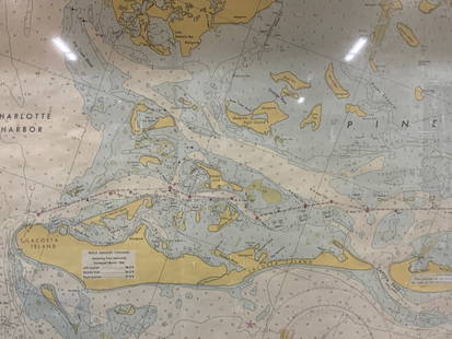
Sold2024Vintage Framed Pine Island & Lacoste Island MapVintage full color paper map, marked on top Pine island, Charlotte harbor and Lacosta island. Showing waterways and directions. Framed in a wooden frame. Approx 14 x 18 inches window measures 11.5 x 1See Sold Price
Sold2021Shell Tin Litho Road Maps DisplayCanadian. 1940s. Lithographed tin. Includes an assortment of seventeen (17) used road maps. Marked, "St. Thomas Metal Signs Ltd. St. Thomas Ontario" upper rear. 19 1/2 x 13". One added mounting hole tSee Sold Price
Sold2023Asprey Silver-Mounted Nautical PaperweightAsprey English silver-mounted nautical paperweight, of maritime interest, modeled as a ship's wheel with magnifying glass center, perfect for reading maps, marked to side. [2 3/8" H x 5 7/8" Diam.]. LSee Sold Price
Sold2023Pennsylvania RR Property Atlasbinding damaged and the pages are not attached to the binding, maps in good condition for their age, cover has tears on corners, maps marked copyright 1912, cover says A.H. Mueller PhiladelphiaSee Sold Price
Sold2023Set 8pc PIERO FORNASETTI Italian Coasters. Original Box. "Antichi Plansiferi" Series. Graphic imagesSet 8pc PIERO FORNASETTI Italian Coasters. Original Box. "Antichi Plansiferi" Series. Graphic images of world globes maps. Marked. : W: 4 inches: D: 4 inches --- US Packing and Shipping charge: $35 PlSee Sold Price
Sold2018KPM porcelain plaque 'Whispering Secrets', markedKPM porcelain plaque titled 'Whispering Secrets,' late 19th or early 20th century, depicting a girl holding a candlestick while her companion whispers into her ear, impressed mark on the back, displaySee Sold Price
Sold202418th century cherry Queen Anne 2-pc highboy18th century cherry Queen Anne 2-pc highboy with inlay and carved shell, not a marriage, has a secret map drawer at top (part of the crown molding), dovetailed case and drawers, 69.25"T x 39.25"W x 20See Sold Price
Sold2023'MAP', Sterling Silver Water PitcherSterling silver water pitcher, with spherical body, wide spout, scrolled handle, marked "MAP" total weight: 31.16 ozt. height 9 in. x width 9.5 in. x depth 7 in. Provenance: The Estate of cardiologSee Sold Price
Sold2022Hamilton MFG Map CabinetVintage wooden map cabinet, marked Hamilton MFG (Two Rivers, Wisconsin), featuring ten drawers with metal pulls 21"h x 25.5"d Provenance: A New Braunfels, Texas Collection We happily providSee Sold Price
Sold2022Map of the Town of Cornwall, Connecticut, Circa 1854Map of the Town of Cornwall, Connecticutcirca 1854marked "Map of the Town of Cornwall, Litchfield County, Connecticut, Surveyed & Drawn by L. Fagan, Published by Richard Clark, 42, Moyamensing RoSee Sold Price
3 days LeftAsian Antique GroupAncient Du Jin sermons spread secret map hand scroll long Qianlong imperial title Xi Gang, Liu$300
4 hrs LeftJasper52MALAY ARCHIPELAGO/EAST INDIA ISLANDS. Philippines Indies. RAPKIN/TALLIS 1851 map$260
4 hrs LeftJasper52Carte du Lac de Genève et des pays circonvoisins'. Geneva plan. CHOPY 1740 map$550
6 days LeftJasper521699 Moll World Map with Cowley's Voyages -- Nouvelle Carte du Monde Suivant l'idee de Mercator ou$240
4 hrs LeftJasper52Northern Ayrshire. Troon Irvine Ardrossan Kilmarnock Prestwick. THOMSON 1832 map$360
4 hrs LeftJasper52ZEELANDIA INSULA DANICARUM MAXIMA. Seeland Sjælland Copenhagen BLAEU c1667 map$260
6 days LeftJasper52c1863 Civil War era Virginia with Washington D.C. and View of The Capital. By C. Magnus$240
4 days LeftGreat Estates Auctioneers & AppraisersRENAISANCE REVIVAL STERLING SILVER SECRET LOCKET$100
18 hrs LeftAlexander Historical Auctions LLC‘SECRET’ MAP OF OKINAWA PREPARED JUST DAYS BEFORE BATTLE$750
4 hrs LeftJasper52Amér Sep Partie de… Vieille Californie #53 Baja California VANDERMAELEN 1827 map$260


![Asprey Silver-Mounted Nautical Paperweight: Asprey English silver-mounted nautical paperweight, of maritime interest, modeled as a ship's wheel with magnifying glass center, perfect for reading maps, marked to side. [2 3/8" H x 5 7/8" Diam.]. L](https://p1.liveauctioneers.com/1221/307463/164563035_1_x.jpg?height=310&quality=70&version=1698950938)


