Sold2017G.P Strum: Antique Map of Indian Territory, 1883Title: Map of Indian Territory by G.P Strum Date: 1883 Medium: Lithograph Dimensions (in): 33.5 x 25.5 Condition: Great Condition No Reserve: This lot starts at $1 and has no reserve as a courtesy soSee Sold Price
Sold2018Asher & Adams: Antique Map of Indian Territory, 1874Title/Content of Map: 1874 Asher & Adams Indian Territory Map -- Asher & Adams Indian Territory and Texas North West Portion Date Printed: 1874, New York Cartographer: Asher & Adams Size: 16.3 x 23.2See Sold Price
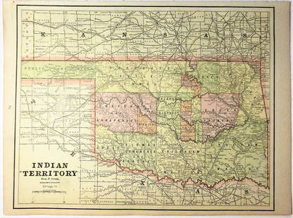
Sold2017Cram: Antique Map of Indian Territory, 1891Map: Indian Territory Date: 1891 From Cram's "Unrivaled Family Atlas of the World Indexed" Size: 14.5 x 11 inches George F. Cram (1842-1928) served in the U.S. Army during the American Civil War. AfteSee Sold Price
Sold2016Antique Map : Oklahoma Indian Territory - 1903Antique Map : Oklahoma Indian Territory - 1903. Size : 21.5" x 13.5"See Sold Price
Sold2023Two Antique Maps of Indian Territories British America Far WestTwo Antique Maps of Indian Territories British America Far West MEDIUM: Published Printing DIMENSIONS: Framed 18 x 27 inches DESCRIPTION: These early antique maps of British America show Districts, InSee Sold Price
Sold2017Fullarton: Antique Map of Texas & Indian Territory 1860Map: 1860 Fullarton Map of Texas (East/Central), Indian Territory, Louisiana and Arkansas -- United States North America According to Calvin Smith& Tanner . . . South Central Section. Comprising TexasSee Sold Price
Sold2017Cram: Antique Map of Texas, Indian Territory, ArkansasTitle/Content of Map: 1885 Cram Map of Texas, [verso] Indian Territory and Arkansas -- Texas, [verso] Indian Ty; Arkansas Date Printed: 1885, Chicago Cartographer: G Cram Size: 12 x 17 in. This is a nSee Sold Price
Sold2017Rand McNally: Antique Map of Texas & Indian TerritoryMap: 1895 Rand McNally Map of Texas and Indian Territory/Oklahoma -- Texas; Oklahoma and Indian Territory Cartographer: Rand McNally Year / Place: 1895 Chicago Map Dimensions: 9.2 x 12.5 in. ConditionSee Sold Price
Sold2017Rand McNally: Antique Map of Texas & Indian TerritoryTitle/Content of Map: 1895 Rand McNally Map of Texas and Indian Territory/Oklahoma -- Texas; Oklahoma and Indian Territory Date Printed: 1895 Chicago Cartographer: Rand McNally Size: 9.2 x 12.5 in. CoSee Sold Price
Sold2017Lloyd: Map of Kansas and Other Territories, 1872Map: Kansas, and the Territories of Arizona, Colorado, New Mexico, Utah and Indian Territory (antique map) Cartographer: H.H. Lloyd Publisher: Stedman, Brown & Lyon Date: 1872 Size: 15.375 x 24.5 inchSee Sold Price
Sold20201883 Map of the Indian TerritoryAuthor: Cram Title: 1883 Map of the Indian Territory Medium: Ink on Paper Dimensions: 13.5"X11" Map of the Indian Territory dated 1883. Engraved and published by George Cram in Chicago. Key lower leftSee Sold Price
Sold2019AN ANTIQUE MAP, "Map of Oklahoma and Indian Territory,"AN ANTIQUE MAP, "Map of Oklahoma and Indian Territory," 1890-1892, color engraving on paper, copyrighted by Mast, Crowell & Kirkpatrick, with view of Beaver. 10.375" x 13" Note: Showing populations oSee Sold Price
Sold20181883 General Land Office Map of Indian TerritoryTitle/Content of Map: 1883 General Land Office Map of Indian Territory -- Indian Territory Date Printed: 1883, Washington Cartographer: General Land Office Size: 12 x 16 in. This is a highly detailedSee Sold Price
Sold2018Tallis/Rapkin: Antique Map of West Canada, 1849TITLE/CONTENT OF MAP: 'West Canada' The map shows the eastern part of modern Ontario, divided into districts/counties. Part of the map is shown as "Indian territory", with "Indian traders" marked. VigSee Sold Price
Sold2018Cram: Antique Map of Texas, 1886Title/Content of Map: 1886 Cram Map of Texas / Arkansas and Indian Territory on Verso -- Texas; Arkansas; Indian Ty. Date Printed: 1886, Chicago Cartographer: G Cram Size: 11.8 x 17 in. Handsomely detSee Sold Price
Sold2018Rand McNally: Antique Map of Texas, 1894Title/Content of Map: 1894 Rand McNally Texas [verso] Indian Territory, N Dakota -- Texas [verso] Indian Territory, North Dakota Date Printed: 1894, Chicago Cartographer: Rand McNally Size: 18.3 x 13.See Sold Price
Sold2021Very scarce Indian Territory/Texas, Cram 1882Scarce two-page, hand-colored map of Indian Territory and Northern Texas from the very early and scarce 1882 Cram’s Unrivaled Family Atlas of the World. All Cram atlases prior to 1883 are extremSee Sold Price
Sold2020Indian Territory 1891Title/Content of Map: Indian Territory 1891 Date Printed: 1891 Material/Medium: Paper Size: approx 10.5x14.5 inches Additional Info: Cram's Atlas of the World. Geo. F. Cram, Chicago Reserve: $20.00 SSee Sold Price
Sold2020Indian Territory 1897Title/Content of Map: Indian Territory 1897 Date Printed: 1897 Material/Medium: paper Size: approx. 11x 13.5 inches Additional Info: Cram's Universal Atlas Reserve: $30.00 Shipping: Domestic: Flat-ratSee Sold Price
Sold2021Government map of Indian TerritoriesHeading: (Indian Territory) Author: Dinsmore, A. F., Lowe, R.P., Naylor, William, Cartographers Title: Indian Territory. Department of The Interior General Land Office. Hon. Thomas H. Carter, CommissiSee Sold Price
Sold20181890 Census Office Map of Indian Territory and OklahomaTitle/Content of Map: 1890 Census Office Map of Indian Territory and Oklahoma -- Map of Indian Territory and Oklahoma Date: 1890, Washington Cartographer: General Land Office / Census Office Size: 22.See Sold Price
Sold202119th C. Map of Indian Territory & 20th C. Kachina**Originally Listed At $300** Map: "Map of Indian Territory Drawn and Engraved on Copper Plate Expressly for Johnson's Cyclopedia" - Volume IV New York - A.J. Johnson Company, ca. 1880 to 1894. FigureSee Sold Price
Sold2021Scarce map of Indian Territory, 1886Most likely the final map of Indian Territory produced by the Colton firm. Map is colored by Indian Nations, and shows a massive Cheyennes and Arapahoes Nation at the top. Over two dozen Native AmericSee Sold Price
Sold2020Map of Indian TerritoryTitle/Content of Map: Map of Indian Territory Date: 1899 Cartographer: U.S. GEOLOGICAL SURVEY Publisher: U.S.G.S. Size: 32.5Height - 29.5Width showing distribution of woodland. Compiled under the direSee Sold Price
2 days LeftTrillium Antique Prints & Rare BooksCarey, pub. 1814 - Map of the Mississippi Territory$60(2 bids)
6 days LeftJasper52PACIFIC OCEAN showing British French Dutch US territory. US Philippines 1947 map$20
5 hrs LeftJasper52Antique 1808 Map of the United States of America On Silk School Girl Mary Russell$50
5 days LeftJasper52c1720 World showing Dutch East India Co possessions. CA as a island. By J.Malherbe$650
3 days LeftKCM Galleries1800s GUSTAVE DORE "Atala" Wood Engraving "Grieving Mother" FRAMED Signed$225
2 days LeftNadeau's Auction GalleryMap of the Northwest Port of Canada, Indian Territories Hudson's Bay$150
5 days LeftJasper521792 ANCIENT HISTORY of INDIA antique ILLUSTRATED w/ MAPS 18th CENTURY in FRENCH$170


![Cram: Antique Map of Texas, Indian Territory, Arkansas: Title/Content of Map: 1885 Cram Map of Texas, [verso] Indian Territory and Arkansas -- Texas, [verso] Indian Ty; Arkansas Date Printed: 1885, Chicago Cartographer: G Cram Size: 12 x 17 in. This is a n](https://p1.liveauctioneers.com/5584/113749/58452563_1_x.jpg?height=310&quality=70&version=1513734097)


![Rand McNally: Antique Map of Texas, 1894: Title/Content of Map: 1894 Rand McNally Texas [verso] Indian Territory, N Dakota -- Texas [verso] Indian Territory, North Dakota Date Printed: 1894, Chicago Cartographer: Rand McNally Size: 18.3 x 13.](https://p1.liveauctioneers.com/5584/115725/59466797_1_x.jpg?height=310&quality=70&version=1517366277)


![[Maps] American Atlas, Folio (1 of 14)](https://p1.liveauctioneers.com/3532/326332/175680379_1_x.jpg?height=282&quality=70&version=1713151485)


