Sold201718th Century French Map of North AmericaL’Amerique Septentrionale. Daniel de la Feuille (1640-1709). Engraved map with hand color in full. Amsterdam, 1702 or 1706. 6 x 8 inches visible, 13 x 14 1/2 inches framed. Nicely colored early 18thSee Sold Price
Sold2023Colored Map Engraving of North America Before the French Indian War 18th CenturyCharte von dem Engellaendischen u. Franzoesischen Besitzungen in Nord America. This map detail delineation of the English and French colonies prior to the French and Indian War pg. 8. This hand coloreSee Sold Price
Sold202218th C. MAPS OF NORTH AMERICA & CARIBBEAN (2 MAPS)Includes: Brian de la Tour, Louis. L'AMERIQUE DRESSEE POUR L'ETUDE DE LA GEOGRAPHIE (Paris, 1764).Copperplate engraved map of North and South America. Hand colored. Matted and framed. H. 11", W. 12" BSee Sold Price
Sold2018LAURIE & WHITTLE BRITISH 18TH CENTURY MAP OF NORTHLAURIE & WHITTLE BRITISH 18TH CENTURY MAP OF NORTH AMERICA, hand-colored, title in cartouche to upper right corner "A NEW AND CORRECT MAP / OF THE / BRITISH COLONIES IN NORTH AMERICA / Comprehending /See Sold Price
Sold2017De Vaugondy: Amerique SeptentrionaleMap: Amerique Septentrionale Maker/Publisher: De Vaugondy, Robert, Paris Publishing Date: 1748 Size: 6.25 x 7.75 inches Interesting mid-18th century map of North America, published by Robert De VaugonSee Sold Price
Sold2021Jacobus Keizer 18th C.Dutch engraved Map of NorthThis 18th Century map of North America is written in Dutch (possibly a bookplate) is a hand colored copper engraving by noted Dutch Cartographer Jacobus Keizer 1710-1745. Quality matted and framed, itSee Sold Price
Sold2018ANTONIO ZATTA (ITALIAN, 18TH CENTURY) MAP / ATLAS OFANTONIO ZATTA (ITALIAN, 18TH CENTURY) MAP / ATLAS OF NORTH AMERICA, SET OF 12, hand-colored, on laid paper, comprising title page lettered in part "LE / COLONIE UNITE / DELL' / AMERICA SETTENTR'LE." aSee Sold Price
Sold20201761 MAP OF NORTH AMERICA BY ROCQUE18th century map GENERAL MAP OF NORTH AMERICA 1754-1761 by John Rocque, London by A. Drury, 2 part map, 35.5 x 36 inches, good condition.See Sold Price
Sold2018Pair of Maps, North America, 18th c.Including ** "A Map of the Island of Orleans with the Environs of Quebec" (hand-colored) and "An Authentic Plan of the River St. Laurence, from the Sillery to the Falls of Montmorency." Both circa 175See Sold Price
Sold2022Reproduction of 18th Century North America MapReproduction of 18th Century North America Map This map is a 20th century hand-colored lithographic reproduction of a 17th century map of the colonial territories held by Spain, England, and France. TSee Sold Price
Sold2019Hand-Colored Map of North America, 18th c."Carte du Continent de L'Amerique Nord." Circa late 18th c. On laid, sheet 14" x 11.5". Hand-colored, a couple of small marginal tears and light marginal chipping, the whole with some creases (as prevSee Sold Price
Sold2019Unknown, "An Accurate Map of North America," 18th c.,Unknown, "An Accurate Map of North America," 18th c., mounted and matted, H. -8 1/2 in., W. - 14 in.See Sold Price
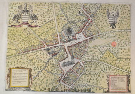
Sold201518th C French Map Of SteenvoordePLOUICH, Vedastus du -" Illvstrissimo viro domino" .The city of Steenvoorde is a small town located north of France. The city of Steenvoorde is located in the department of Nord of the french region.See Sold Price
Sold2022Group of Six 18th C. Copper-Engraved MapsLot comprised of six 18th century maps: 1) Copper-engraved map, circa 1794, of North America at the end of the 18th century, with the configuration of the northwest coast and Alaska growing ever moreSee Sold Price
Sold2020Map of North America, 1797Ca. late 18th c. engraved map, on laid paper. "A New Map of North America Shewing all the New Discoveries, 1797." Sheet 9.5" x 8.25". From Morse's Gazetteer of America.See Sold Price
Sold2022(COLONIAL NORTH AMERICA.) Group of 3 small format 18th-century engraved maps.(COLONIAL NORTH AMERICA.) Group of 3 small format 18th-century engraved maps. London, vd - The Royal Magazine; G. Rollos, engraver. A New and Accurate Map of the Present Seat of War in North America.See Sold Price
Sold2023French map of North America published by Bonne 1781 sea of the westRigobert Bonne (6 October 1727 – 2 September 1794) work represents an important step in the evolution of the cartographic ideology away from the decorative work of the 17th and early 18th centurSee Sold Price
Sold2017Morisot: Antique Map of North America, 1643Title: Americae Septentrionalis Circuitus. Mid-17th century French copperplate map with cartographic myths Map maker: Claude Bartholomy Morisot Place and Year: Dijon, 1643 Dimensions: 16.6 x 13.5 cm (See Sold Price
Sold2022Antique French map of North America by N. LorrainAntique French map of North America (Amerique Septentrionale' by N. Lorrain. Marked on bottom Longitude Occidentale de Paris. Early 20th century. 22 3/4"h x 25 1/4"wSee Sold Price
Sold20231748 Map of North America, Comprehending 'The Course to Ohio'America, 18th century. An early map of the eastern coast, detailing New England, New York, and more. No maker marks present. Overall good condition; complete on laid paper.See Sold Price
Sold20221782 ATLAS MAPS Expilly Geography Voyages Travel World America Asia Africa1782 ATLAS MAPS Expilly Geography Voyages Travel World America Asia Africa Jean-Joseph Expilly was an 18th-century French geography and historian who published numerous works on cosmography, history oSee Sold Price
Sold20221777 ATLAS MAPS Expilly Geography Voyages Travel World America Asia Africa1777 ATLAS MAPS Expilly Geography Voyages Travel World America Asia Africa Jean-Joseph Expilly was an 18th-century French geography and historian who published numerous works on cosmography, history oSee Sold Price
Sold20231761 ATLAS MAPS Expilly Geography Voyages Travel World America Asia Africa1761 ATLAS MAPS Expilly Geography Voyages Travel World America Asia Africa Jean-Joseph Expilly was an 18th-century French geography and historian who published numerous works on cosmography, history oSee Sold Price
Sold20231765 ATLAS MAPS & Voyages Pluche Geography Asia Arabia Greece America Egypt1765 ATLAS MAPS & Voyages Pluche Geography Asia Arabia Greece America Egypt Noël-Antoine Pluche was an early 18th-century French priest and historian who is most remembered today for his landmark wSee Sold Price
May 18Rich Penn AuctionsDecorative Art, map of South America, late 18th C., framed & matted, Exc cond, 24"H x 20"W overall.$50
May 16DuMouchellesFrench And American Louis XVI Period And Style Bleached Wood Armchairs, 18th & 20th C., H 40" W$150
May 10New England Auctions - Fred Giampietro18th c Wrought Iron French Torchiere Lighting Fixture$50(1 bid)
BonhamsAFTER OGATA KŌRIN A Small Inlaid-Lacquer Three-Case InrōEdo period (1615-1868), 18th c...$600(2 bids)
2 days LeftTrillium Antique Prints & Rare BooksBonne - Map of the Eastern Coast of North America$85(3 bids)
May 10New England Auctions - Fred GiampietroLarge Curved Segment from an 18th C French Granite Cider Mill$100(1 bid)
May 10New England Auctions - Fred GiampietroLarge Curved Segment from an 18th C French Granite Cider Mill$250(1 bid)
May 10New England Auctions - Fred GiampietroLarge Curved Segment from an 18th c. French Granite Cider Mill$100
May 11Zevantiques18 Century French Small Sword Or Epee With Exquisitely Decorated Silver Hilt And Shell Guard$350
May 11ZevantiquesMagnifesent 18th C. French Nobleman Hunting Sword Dagger AGATE Handle With Silver Mounts. Blade Is$650
May 11ZevantiquesExceptional Quality 18th C. French or English Aristocrat's Rapier Sword in Exquisite Mercury Gold$1,200
1 day LeftPrime Auction Gallery, Inc.Late 18th C. French Louis Style XV Marquetry Bronze Mounted Commode$1,700
1 day LeftAuction Plus, Inc.Set Of Four Late 18th C. French Hand Painted Jeweled & Enamel Sevres Plates$4,000