Sold2017EXCELSIOR SERIES MAP - THIS IS A FANTASTIC 1926 MAPEXCELSIOR SERIES MAP - THIS IS A FANTASTIC 1926 MAP WALL HANGING DOUBLE-SIDED WITH SOME TAPE REPAIRS - PUBLISHED BY GEOGRAPHICAL CHICAGOSee Sold Price
Sold2017A 1926 Map Series of Three Plate Block of Six Stamps,A 1926 Map Series of Three Plate Block of Six Stamps, Scott C7-C10, mint, never hinge. Together with a 10 cent Linberg stamp.See Sold Price
Sold2021San Antonio Conservation Society 1926 MapVintage 1926 San Antonio Conservation Society historic guide map of San Antonio de Bexar, drawn by Emily Edwards, portrays San Antonio from 1682-1721, unframed 39 x 28"; Provenance: A Schertz, TX EsSee Sold Price
Sold2022San Antonio Conservation Society 1926 MapVintage 1926 San Antonio Conservation Society historic guide map of San Antonio de Bexar, drawn by Emily Edwards, portrays San Antonio from 1685-1721, framed, dated 1926 41"h x 30"w Provenance: A SSee Sold Price
Sold20191926 Map of Cape Cod by Elisabeth Leonard FramedVintage original map of Cape Cod by Melanie Elisabeth Leonard of Sandwich printed 1926. Colorful and whimsical details throughout. 24 x 34 visible. Framed to 25.75 x 36.5. Some fold lines. ExcellenSee Sold Price
Sold2017Homann: Map of Russia, 17531753 J. Homann Map of Russia -- Imperii Russici et Tartariae Universae tam Majoris et Asiaticae, quam Minoris et Europaeae Tabula. 1753 Nurnberg. 19.2 x 22.4 in. A fantastic map of Russia from the BalSee Sold Price
Sold2017Carte de l'Ocean Occidental DresseeMap: Carte de l'Ocean Occidental Dressee pour Servir a l'Histoire Generale des Voyages, 1746 Maker: J Bellin Date: 1746, Paris Description: This is a fantastic map of the North Atlantic. It is centereSee Sold Price
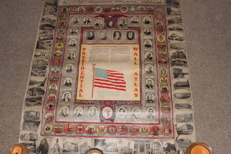
Sold2022Educational Map of Standard Geographical Terms, Denoyer-GeppertEducational Map of Standard Geographical Terms, Denoyer-Geppert. This is a fantastic map featuring elementary geographical vocabulary and terms with definitions indexed on the bottom. It was made by DSee Sold Price
Sold20181851 Tallis Map of Sri Lanka / Ceylon -- CeylonTitle/Content of Map: 1851 Tallis Map of Sri Lanka / Ceylon -- Ceylon Date: 1851, London Cartographer: J Tallis Size: 13 x 9.2 in. This is a fantastic map of Ceylon (Sri Lanka), the 'Pearl of the Sea'See Sold Price
Sold20191840 SDUK Map of West Africa -- West Africa ITitle/Content of Map: 1840 SDUK Map of West Africa -- West Africa I Date: 1840 London Cartographer: SDUK Size: 12.2 x 15.1 in. This is a fantastic Map of todays Mauritania (in part), Senegal, Gambia,See Sold Price
Sold20181882 Rand McNally Map of Europe -- Rand McNally &Title/Content of Map: 1882 Rand McNally Map of Europe -- Rand McNally & Company's Indexed Atlas of the World (Europe) Date: 1882, Chicago Cartographer: Rand McNally Size: 13 X 19.4 in. A fantastic mapSee Sold Price
Sold20181882 Stanford Map of Ceylon (Sri Lanka) -- CeylonTitle/Content of Map: 1882 Stanford Map of Ceylon (Sri Lanka) -- Ceylon Date: 1882, London Cartographer: E Stanford Size: 13 X 10.6 in. This is a fantastic map of Ceylon (Sri Lanka). Extraordinary detSee Sold Price
Sold2019Andrews' Series of Wall Maps. Map of the United StatesTitle/Content of Map: Andrews' Series of Wall Maps. Map of the United States Mexico and Parts Of Canada and the West Indies Date: c1889 Cartographer: G.W. Bacon Publisher: A.H. Andrews & Co. Size: 45HSee Sold Price
Sold2016GERTRUDE A. STRICKLER COLORED GRAPHIC MAP C. 1926GERTRUDE A. STRICKLER COLORED GRAPHIC MAP, C. 1926, 29" X 37", 'DOWNTOWN ANN ARBOR TOWN':Unframed. Produced by Jesse Horton Koessler (U of M grad, 1901). For a high resolution photoSee Sold Price
Sold2021Boston Massachusetts Pictorial MapThe Colour of an Old City. Edwin Olsen and Blake Clark. Houghton Mifflin, Boston: 1926. Illustrated map. Ex library. 28 1/2" x 38".See Sold Price
Sold2018Antique Edo Period Japanese Map of Tokyo, 1864Title/Content of Map: 1864 Edo Period Japanese Map of Tokyo -- [Tokyo] Date Printed: 1864 c. Cartographer: Anonymous Size: 28 x 36 in. This is a fantastic folding map of Tokyo from the latter part ofSee Sold Price
Sold2016J. Tallis: United States, 1851Map: United States Cartographer: J. Tallis Publishing: London, 1851 Medium: Engraving Size: 9.5 x 13.5 inches This is fantastic engraved map shows the young US republic in the early 1850's. Aside fromSee Sold Price
Sold2022Cram's Double Sided Railway Map in Industrial Frame, New York & S. New England, MA, CT & RICram's Double Sided Railway Map in Industrial Frame, New York & S. New England, MA, CT & RI. Fantastic educational maps on hard board showing railways and census information are marked The George CramSee Sold Price
Sold2021Pacific Electric Railways Transit System MapThis cool map is a reprint of the 1926 route map for Pacific Electric Railways. Reprinted by Orange Empire Railway Museum and features all the stops and cities that were served by the trolley lines. NSee Sold Price
Sold2022Large Cram's Double Sided Railway Map in Industrial Frame, Kentucky & LouisianaLarge Cram's Double Sided Railway Map in Industrial Frame, Kentucky & Louisiana. Fantastic educational maps on hard board showing railways and census information are marked The George Cram Co, IndianaSee Sold Price
Sold2022Fashion / Fairytales (4) Pop-Up BooksFour (4) pop-up books. Includes: Once Upon a Time Map Book; Fantastic Fairy Tale with four miniature storybooks; A Walk in Monet's Garden; Fashion a la Mode. Lot measures 12 in. x 9 in. x 5 in. ProvenSee Sold Price
Sold2021COLORFUL c. 1926 SUEZ CANAL MAP w HISTORICAL NOTES byCOLORFUL c. 1926 SUEZ CANAL MAP w HISTORICAL NOTES by ORIENTAL COMMERCIAL BUREAU COLORFUL c. 1926 SUEZ CANAL MAP w HISTORICAL NOTES by ORIENTAL COMMERCIAL BUREAU Description Circa 1926 Antique Map FolSee Sold Price
Sold2022Large Cram's Double Sided Railway Map in Industrial Frame, Idaho & OklahomaLarge Cram's Double Sided Railway Map in Industrial Frame, Idaho & Oklahoma. Fantastic educational maps on hard board showing railways and census information are marked The George Cram Co, IndianapoliSee Sold Price
Sold2022Large Cram's 1930 Double Sided Railway Map in Industrial Frame, Oregon & CaliforniaLarge Cram's 1930 Double Sided Railway Map in Industrial Frame, Oregon & California. Fantastic educational maps on hard board showing railways and census information are marked The George Cram Co, IndSee Sold Price
2 days LeftLarsen Art AuctionKris Cox Concentric Episode Series, MAP (Rings) 24.01.1, 2001$300(1 bid)
Featured4 days LeftJasper521864 Johnson Map of US West -- Johnson's California, with Utah, Nevada, Colorado, New Mexico, and$140
May 01Michael Scarola Rare and Used BooksMilitary Wagon-Road In Wyoming And Montana Territories With Map Of Military Reconnaissance 1873-4$100
6 days LeftJasper52Being a map of Hollywood, from the best surveys of the time. GRIEVE 1926 (1960s)$1,100
6 days LeftJasper52Stratford-upon-Avon & William Shakespeare's life. Kerry Lee pictorial map c1965$440
Featured6 days LeftJasper52LSE POVERTY OS PROOF MAP Wanstead Flats - Aldersbrook - Forest Gate 1928$700
6 days LeftJasper52LSE POVERTY OS PROOF MAP West Ham Park - Plashet - Forest Gate - Woodgrange 1928$750
6 days LeftJasper52LSE POVERTY OS PROOF MAP West/East Ham - Plaistow - Upton Park - Greengate 1928$850


![Antique Edo Period Japanese Map of Tokyo, 1864: Title/Content of Map: 1864 Edo Period Japanese Map of Tokyo -- [Tokyo] Date Printed: 1864 c. Cartographer: Anonymous Size: 28 x 36 in. This is a fantastic folding map of Tokyo from the latter part of](https://p1.liveauctioneers.com/5584/116691/60001785_1_x.jpg?height=310&quality=70&version=1519176922)


