2022Blaeu, Johannes (Netherlands, 1596-1673) "The New World Map" Double Hemisphere World Map C. 1664Nova et Accuratissima Totius Terrarum Orbis Tabula Translated "The New World Map", Hand Colored w/ Elaborately Decorated Spandrels.   Sight View 16" x 21-1/2", Overall View 21" x 25-1/2"See Sold Price
Sold2019New World Map Jig-Saw PuzzleReserve Reduced! Title/Content of Map: New World Map Jig-Saw Puzzle Date: c1940 Material/Medium: H. M. Gousha Size: 26Height - 43Width Box title: New World Map Jig-Saw Puzzle / 8 colors / (size 43 in.See Sold Price
Sold2017Gabriel Tatton: The New World Map, 1600The New World Map 1600” drawn by Gabriel Tatton - reproduction by American Heritage, the magazine of history. Measurement approximate: 24” x 18”. Condition: Very Good Please note that this lSee Sold Price
Sold2017New Worlds, Maps from the Age of Discovery, 1st EdTitle: New Worlds. Maps from the Age of Discovery. London. Quercus. 2006 Author(s): Baynton-Williams, Ashley and Miles First edition. Condition: Fine copy in fine dust jacket (in mylar) Folio. Hard coSee Sold Price
Sold2017Gabriel Tatton: Map of The New World, 1600The New World Map. 1600. Drawn by Gabriel Tatton. Engraved by Benjamin Wright. 24 x 18 inches. Please note that this lot has a confidential reserve. When you leave a bid in advance of the auction, subSee Sold Price
Sold2018Early 19th century School Girl Embroidery of OldEarly 19th century School Girl Embroidery of Old World-New world maps surrounded by floral garland decoration. Loss to silk and embroidery. Framed. Overall size: 21" x 29".See Sold Price
Sold2017(3) Antiquarian Books,Washington, 1864 & New World,1857Collection of 1st edition antiquarian books. 19th century historic book on George Washington & 2 volumes on American New World history. Maps, colored lithographs, wood and steel engravings throughoutSee Sold Price
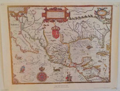
Sold2023The New World 1600 Tatton MapSite: 16" x 20.5" H 24.25 W 28.75 D 0.75 Weight 8 lbsSee Sold Price
Sold2021Antique Map Lithographs New York City, World MapPair Antique Hand Colored Map Lithographs of New York City, and a World Map. Unframed 18 inches x 23 inchesSee Sold Price
Sold20221964 New York World's fair Map and Two Admissions Tickets1964 New York World's fair Map and Two Admissions TicketsSee Sold Price
Sold2022Buffon & Tardieu 1853 Map. New World"Carte de Nouveau Continent" Steel Engraved Map with outline hand color Published 1853-55, Paris for "Oeuvres Completes de Buffon" by the Comte de Buffon. Engraved by Ambroise Tardieu. Paper Size: 10See Sold Price
Sold20151939 New York World's Fair Maps from Esso, Shell, Gulf,1939 New York World's Fair Maps from Esso, Shell, Gulf, AAA, Sunoco and others: A wonderful group of gasoline and other maps showing the 1939 NYWF. There are a number of companies including: Liggetts,See Sold Price
Sold2021Vintage World's Fair & York Fair MapsAtlantic New York World's Fair map, 1965 Souvenir World's Fair map, 1964 and 1970 York Fair Handbooks, 1968 Presidential Handbook, 1915 PO of A medal with ribbon, heritage stamps, and other items.See Sold Price
Sold2017Sanson: Antique Map of New World as Atlantis, 1690Map: Atlantis Insula Cartographer: G. Sanson / Covens & Mortier Place & Date: Amsterdam / 1690 Size: 21 1/2" x 16" Condition: outline color; overall age toning; minor fraying at edges of margins. TheSee Sold Price
Sold20211830 "A New Atlas World" Educational School Map Book1830 "A New Atlas World"Antique Educational School Maps. This is a wonderful antique atlas for early education, geography classes. It has a layout of the world and the breakdown of each continent. BecSee Sold Price
Sold2022New York World's Fair 1940 MapUp for auction is a recent estate find, a 1940's map of the New York World's Fair. The 1939-1040 World's Fair was turbulent, seeing the demolition and removal of the Axis country sections, including tSee Sold Price
Sold2017Gray Double Hemisphere World Map,18791879 Gray Double Hemisphere World Map -- Gray's New Map of the World in Hemispheres, with Comparative Views of the Heights of the Principal Mountains and Lengths of the Principal Rivers on the Globe.See Sold Price
Sold2018Rand, McNally & Co.'s Indexed Atlas of the World Map ofTitle/Content of Map: Rand, McNally & Co.'s Indexed Atlas of the World Map of New York City Date: 1892 Cartographer: RAND, MCNALLY & CO. Size: 26X19 Pages 62-63 in Rand, McNally & Co.'s Indexed atlasSee Sold Price
Sold2021TWO ITALIAN 1893 COLUMBIAN EXPO MEDALS.Bronze. Christopher Columbus with map of New World on front and two goddesses overlooking fair building on reverse. One in good condition with minor corrosion, the other has been cleaned with edge nicSee Sold Price
Sold2017COLLECTION OF MAPSWORLD MAP, ASIA, NEW YORK CENTRAL, COLORADO, ALSO BROCHURES INCLUDING SHELL GAS STATION AND OTHERS.See Sold Price
Sold2021LLADRO, "COLUMBUS" w/ COMPASS by SALVADOR FURIO, 1982:LLADRO, "COLUMBUS" w/ COMPASS by SALVADOR FURIO, 1982: Glazed Finish, Measures 17" x 9" x 6". Columbus Plans his Voyages to the New World with Globe and Maps. Has Compass that are often Missing. LimitSee Sold Price
Sold2024NICOLAES VISSCHER (NETHERLANDS, 1618-1709) MAP OF THE NEW WORLD"Novi Belgii Novaeque Angliae nec non Partis Virginie Tabula multis in locis emendata", 1656. Handcolored copperplate engraving on two joined sheets of wove paper as issued. Features cartouche panoramSee Sold Price
Sold20231600s Map of the New World drawn by Gabriel Tatton & engraved by Benjamin WrightMeasurements:With frame- 20" x 25.75"Without frame- 17.75" x 22.75"Weight- 5 lb. A portion of the proceeds from Lots 1-40 are going to the Gibbes Museum of Art in memory of Katherine M. Huger**ShippinSee Sold Price
2017Juan de la Cosa "Map of the New World 1500"Item: Juan de la Cosa "Map of the New World 1500" Description: Vintage reproduction map drawn by Juan De La Cosa By American Heritage, the magazine of history Dimensions: 24” x 18” Please note thaSee Sold Price
1 day LeftJasper52Descrittione… Santa Croce Mondo Nuovo PORCACCHI North America New World 1590 map$700
Apr 30Jasper521719 Chatelain World Map -- Mappe-Monde pour Connoitre les Progres & les Conquestes les Plus$280
Apr 30Jasper52New Map of That Portion of North America Exhibiting the United States and Territories...Mexico...$360
May 16Potter & Potter Auctions[NEW YORK CITY – PICTORIAL MAPS]. Group of 3 pictorial maps...$200(1 bid)
2 days LeftRapid Estate Liquidators and Auction Gallery6 1980s 1990s National Geographic Magazines A$35
3 days LeftRapid Estate Liquidators and Auction GalleryNew Fantasyland Special Editon Eyes And Ears 2012$15
May 01Jasper52MELANESIA.New Caledonia.Ponérihouen-Bourail.WW2 ROYAL NAVY INTELLIGENCE MAP 1944$10


![[NEW YORK CITY – PICTORIAL MAPS]. Group of 3 pictorial maps... (1 of 3)](https://p1.liveauctioneers.com/928/325952/175495562_1_x.jpg?height=282&quality=70&version=1712935174)


