Sold20181843 William Woodbridge World Map1843 William C. Woodbridge Moral and Political Chart of the Inhabited World. Measures 12" x 17.5" (sheet size). G-Vg/Vg condition. Unframed, loose and not mounted or glued down. We ship all items in tSee Sold Price
Sold20181843 William Woodbridge United States Map1843 William C. Woodbridge Physical Map of the United States. Measures 12" x 17 5/8" (sheet size). G-Vg/Vg condition. Unframed, loose and not mounted or glued down. We ship all items in this auction iSee Sold Price
Sold2019William Woodbridge, "Political Map of the SouthernWilliam Woodbridge, "Political Map of the Southern States Division of the United States," 1843, H. - 12 in., W. - 18 3/4 in.See Sold Price
Sold2021Map of the United States20th C. Adapted to Woodbridge's Geography, entered according to Act of Congress in the year 1843 by William C. Woodbridge. Sight size: 11-1/2"h x 17-1/2"w Overall: 18-1/4"h x 24"wSee Sold Price
Sold2019Moral and Political Chart of the Inhabited WorldReserve Reduced! Title/Content of Map: Moral and Political Chart of the Inhabited World Date: c1845 Cartographer: WOODBRIDGE, WILLIAM CHANNING Material/Medium: BELKNAP AND HAMERSLEY Size: 8.25Height -See Sold Price
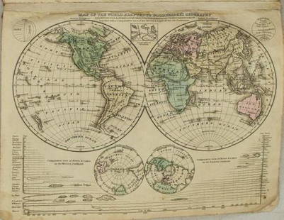
Sold20241822 Woodbridge World Map -- The WorldTitle: 1822 Woodbridge World Map -- The World Cartographer: W. Woodbridge Year / Place: 1822, Hartford Map Dimension (in.): 9.4 X 12.3 in. page This is a very nice double hemisphere world map. It alsoSee Sold Price
Sold20211831 Woodbridge World Map -- Map of the World AdaptedTitle: 1831 Woodbridge World Map -- Map of the World Adapted to Woodbridge's Geography Cartographer: W. Woodbridge Year / Place: 1831, Hartford Map Dimension (in.): 8.6 X 10.8 in. This is a very niceSee Sold Price
Sold20231821 Woodbridge Thematic World Map -- Moral and Political Chart Of The Inhabited World ...Title: 1821 Woodbridge Thematic World Map -- Moral and Political Chart Of The Inhabited World ... Cartographer: W. Woodbridge Year / Place: 1831, Hartford Map Dimension (in.): 8.2 X 10.8 in. This is aSee Sold Price
Sold20211821 Woodbridge Thematic World Map of Type ofTitle: 1821 Woodbridge Thematic World Map of Type of Inhabitation -- Chart of the Inhabited World Exhibiting the Prevailing Religion, form of Government, Degree of Civilization and Population... CartoSee Sold Price
Sold20211821 Woodbridge Thematic World Map -- Moral andTitle: 1821 Woodbridge Thematic World Map -- Moral and Political Chart Of The Inhabited World ... Cartographer: W. Woodbridge Year / Place: 1831, Hartford Map Dimension (in.): 8.2 X 10.8 in. This is aSee Sold Price
Sold2021Guthrie, William 1806 Map. World HemispheresCopper Engraved Map Published 1806, London for "A New Geographical, Historical and Commercial Grammar..." by William Guthrie. The maps are by John Senex, Thomas Kitchin and others. Folds as issued. PaSee Sold Price
Sold2021Guthrie, William 1798 Map. World HemispheresCopper Engraved Map Published 1798, London for "A New Geographical, Historical and Commercial Grammar..." by William Guthrie. The maps are by John Senex, Thomas Kitchin and others. Folds as issued. PaSee Sold Price
Sold2021Guthrie, William 1798 Map World of Mercators ProjectionCopper Engraved Map Published 1798, London for "A New Geographical, Historical and Commercial Grammar..." by William Guthrie. The maps are by John Senex, Thomas Kitchin and others. Folds as issued. PaSee Sold Price
Sold2022Guthrie, William 1805 Map. World on Mercators ProjectionCopper Engraved Map Published 1805, London for "A New Geographical, Historical and Commercial Grammar..." by William Guthrie. Folds as issued. Paper Size: 10.5 x 8 inch (27 x 21cm) Approx. Some toningSee Sold Price
Sold2022Guthrie, William 1812 Map. World on Mercator's ProjectionCopper Engraved Map Published 1812, London for "A New Geographical, Historical and Commercial Grammar..." by William Guthrie. Folds as issued. Paper Size: 14 x 8 inch (36 x 21cm) Approx. Some toning/oSee Sold Price
Sold20191843 Folding Color German World Maps Europe Americas1843 Folding Color German World Maps Europe Americas Geography Austria RARE Three 19th-century world maps published in Vienna in 1843! Published for use in Austrian high schools, this atlas includes fSee Sold Price
Sold2018Antique Pair Of Maps Of America & The WorldAntique Pair Of Maps Of United States & World, these antique maps are both from W.C. Woodbridge, one map is a world map of the inhabited world, the other is a map of America, the prints have matting bSee Sold Price
Sold2023Lot of 2: Travels Around the WorldOur Journey Around the World, Clark, Harriet E, Francis E., 1896, 6.5” x 9”, 641 pgs. With pullout color map. Travels Around the World, Seward, William H., 1873, 6.5” x 9.5”, 7See Sold Price
Sold2016The World Map from The Best Authorities 1799Map: The World from The Best Authorities. Rollinson Fct. Maker: William Rollinson Size: Double Octavo - 7.5 inches wide Date: 1799 Engraved for the New Encyclopedia. World in joined hemispheres. ZodiaSee Sold Price
Sold2023Antique Western World Map From Dampier's ExplorationsMap of Western World engraving on paper Dampiers Explorations 13 x 18 inches (unframed) William Dampier was an English explorer, navigator, and pirate who lived from 1651 to 1715. He is best known forSee Sold Price
Sold20211843 American Almanac1843 The American Almanac and Repository of Useful Knowledge for the year 1844. Boston: Published by David H. Williams. (Map inside cover). Please see all photos for more details and condition.See Sold Price
Sold2017New Worlds, Maps from the Age of Discovery, 1st EdTitle: New Worlds. Maps from the Age of Discovery. London. Quercus. 2006 Author(s): Baynton-Williams, Ashley and Miles First edition. Condition: Fine copy in fine dust jacket (in mylar) Folio. Hard coSee Sold Price
Sold2021A Group of 11 19th and 20th century maps, comprising:A Group of 11 19th and 20th century maps, comprising: Ethnographic Map of the World. Edinburgh and London: William Blackwood & Sons, N.d.. Plate 23. 17 1/4 x 19 1/2 in. -- Geographical Division & DistSee Sold Price
Sold2019Map of a Reconnaissance of the Black Hills. ...Title/Content of Map: Map of a Reconnaissance of the Black Hills. ... Date: 1874 Cartographer: LUDLOW, WILLIAM (1843-1901) Publisher: WAR DEPARTMENT Size: 25Height - 21Width D. Martin Sculpt. Shows FlSee Sold Price
May 09Hunt and Peck Estate Services, Inc.William Hole "A Description of the land of Gosen, and Moses passage though the Deserts"$50
6 days LeftAlexander Historical Auctions LLCBATTLE OF ST. MIHIEL BATTLE MAP, USED BY COL. WILLIAM J. DONOVAN$200
6 days LeftAlexander Historical Auctions LLCCAPTURED MAP OF VERDUN, USED BY COL. WILLIAM J. DONOVAN$100
6 days LeftAlexander Historical Auctions LLCBATTLE OF ST. MIHIEL BATTLE MAP, USED BY COL. WILLIAM J. DONOVAN$140
6 days LeftAlexander Historical Auctions LLCBATTLE OF ST. MIHIEL BATTLE MAP, USED BY COL. WILLIAM J. DONOVAN$140
6 days LeftAlexander Historical Auctions LLCCAPTURED GERMAN MAP OF ST. MIHIEL, USED BY WILLIAM J. DONOVAN$100
5 days LeftJasper52Stratford-upon-Avon & William Shakespeare's life. Kerry Lee pictorial map c1965$440
6 days LeftAlexander Historical Auctions LLCSECOND BATTLE OF THE MARNE MAPS, USED BY COL. WILLIAM J. DONOVAN$240
6 days LeftAlexander Historical Auctions LLCSECOND BATTLE OF THE MARNE MAPS, USED BY COL. WILLIAM J. DONOVAN$140
5 days LeftAlexander Historical Auctions LLC101ST AIRBORNE 506TH PARACHUTE INFANTRY ‘CURRAHEE SCRAPBOOK’ SIGNED BY FOUR MEMBERS$140
6 days LeftA & A Auction Gallery(41)1940s-50s Army Corps World Maps - Army Map Services, Secretary of Navy, (1)Declassified$60
2 days LeftRapid Estate Liquidators and Auction GalleryLaminated Unique Media The World Map 1996 Edition$15