Sold2023General Chart Map of Alaska (1890)General chart map of Alaska compiled and drawn by Adolph and Henry Lindenkohl, a coast and geodetic survey report for 1890 including Eastern Siberia, Russia, and the Aleutian Islands, dated 1890; unfrSee Sold Price
Sold2018Bellin: Antique Map of Eastern Siberia, 1740Title/Content of Map: Easter Siberia off Sakhalin Island Date Printed: 1740-70's Cartographer: J.N. Bellin & J.F. La Harpe Material/Medium: Paper Size: 15" x 9 3/4" Copperplate engraved. From the 'AbrSee Sold Price
Sold2023TWO EASTERN ISLAND DECORATIVE STATUES, A DRUM AND AN POLYNESIAN STATUE, 20th century. - height: 35TWO EASTERN ISLAND DECORATIVE STATUES, A DRUM AND AN POLYNESIAN STATUE, 20th century. - height: 35 inches.See Sold Price
Sold2020Eastern Siberia. Based on Bering’s travels. RARETitle: Eastern Siberia. Based on Bering’s travels. RARE Date/Period: 1744-1748 Materials: Copperplate engraved. Dimensions: 16 x 9 3/4”. Map by Emanuel Bowen, published by John Harris in 'NavigantSee Sold Price
Sold2021Eastern SiberiaPublication Date: 1838 Title: Eastern Siberia Cartographer: WALKER, J. & C./LUTKE/PIADISCHEV Publisher: S.D.U.K. Height: 12.8 Width: 15.6 "Published by the Society for the Diffusion of Useful KnowledgSee Sold Price
Sold2020Eastern Siberia [Includes Kamtchatka]Title/Content of Map: Eastern Siberia [Includes Kamtchatka] Cartographer: WALKER, J. & C./LUTKE/PIADISCHEV Date: 1852 Publisher: CHARLES KNIGHT/GEORGE COX/S.D.U.K. Size: 12.75Height - 15.5Width "PubliSee Sold Price
Sold2017Bellin: Antique Map of Eastern Siberia, 1750Map: Eastern Siberia Date Printed: 1750-60's Cartographer: Jacques Nicolas Bellin Material/Medium: Paper Size: 14" x 11" Condition: Excellent Copperplate engraving. Double page Map. From the Atlas DeSee Sold Price
Sold2018Mongolia, Manchria with eastern SiberiaMongolia, Manchria with eastern Siberia 1750-60's Jacques Nicolas Bellin 14" x 9 3/4" Atlas De L'Histoire Generale Des Voyages. Copperplate engraved.Double page Maps. Bellin was a member of the RoyalSee Sold Price
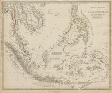
Sold2018Eastern Islands Or Malay ArchipelagoMap: Eastern Islands Or Malay Archipelago Date: 1852 Cartographer: WALKER, J. & C. Publisher: GEORGE COX/S.D.U.K. Size (inches): 12.5X16 Map showing southern Siam, Archipelago Filipino, Celebes, BorneSee Sold Price
Sold2017Eastern Islands Or Malay Archipelago Map, 1836Eastern Islands Or Malay Archipelago. Baldwin & Cradock/S.D.U.K. 1836-12-01. Drawn from authorities Horsburgh, Raffles, Crawfurd, Duperray, Laplace &c. Printed by Russell, Penge. Please note that thisSee Sold Price
Sold2022Easter Island Statue, woodTITLE: Eastern island Staue, wood SIZE (CM): 55x13 Additional information/Date Period:second half 20th C Reserve: $430.00 Shipping: Domestic: Flat-rate of $65.40 to anywhere within the contiguous U.S.See Sold Price
Sold2022Carved Easter Island Head statueLarge carved statue in style of Eastern Island Head, Moai Rapa Nui Statue Tiki figurine. Intricate verso.See Sold Price
Sold2019Sikhote-Alin Shrapnel Meteorite, SiberiaSikhote-Alin Shrapnel Meteorite, Siberia From the north eastern Siberia, the massive daytime fall of Feb. 1947. Of a bit larger than normal size, a nice example of the shrapnel type, a piece that flewSee Sold Price
Sold2022Stone Face Garden Sculpture in style of Eastern IsStone Face Garden Sculpture in style of Eastern Island. 18" x 7" x 6 1/2"See Sold Price
Sold2020MALAY ARCHIPELAGO Indonesia Malaysia PhilippinesTITLE/CONTENT OF MAP: 'EASTERN ISLANDS OR THE MALAY ARCHIPELAGO. Sumatra, Java, Borneo, etc' The top image on the right hand side shows the entire map. To view a close up of the map showing the levelSee Sold Price
Sold2020MALAY ARCHIPELAGO Indonesia Malaysia PhilippinesTITLE/CONTENT OF MAP: 'EASTERN ISLANDS OR THE MALAY ARCHIPELAGO. Sumatra, Java, Borneo, etc' The top image on the right hand side shows the entire map. To view a close up of the map showing the levelSee Sold Price
Sold2020Encyclo. Britannica C1830 Map of East Indies & Burma"Eastern Islands, Birmah &c" Steel Engraved Map Published 1830-42, Edinburgh for "Encyclopedia Britannica" Seventh Edition. Centre fold as issued. Paper Size: 16 x 11 inch (40 x 28cm) Good conditionSee Sold Price
Sold2023Trinidad Island. Eastern Part. West Indies. ADMIRALTY sea chart 1869 (1950) mapTrinidad Island - Eastern Portion' by Bocas Del Dragon to Icacos point from the surveys by Commr. Alun Jones, R.N., and the Officers of H.M. Surveying Ship "Challenger" 1936. Eastern portion of Gulf oSee Sold Price
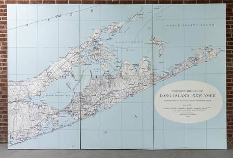
Sold2022Three Panel Water Current Map of Eastern Long Island on Canvas with FrameOver scaled Eastern Long Island water current map on three panel canvas, strengthened on frame. Please note of wear consistent with age. Each panel measures 48"W x 2"D x 96"H.See Sold Price
Sold2020Nautical Map / Sea Chart, #1212 Eastern Long IslandDescription: Nautical Map / Sea Chart, United States East Coast, Connecticut - New York, Long Island Sound, Eastern Part, 12th edition feb 10 / 69 ; all measurements are approximate; Folded; ShippingSee Sold Price
Sold202218th C. Pre-Contact Hawaiian Basalt Adze BladeNorth Pacific, Hawaiian Islands, eastern Big Island, Kalapana, Black Sand Beach, Pre-Contact Period, ca. 18th century CE or earlier. A hand-carved basalt hand tool known as an adze with a trapezoidalSee Sold Price
Sold2015J.B. Hartranft Oil on Canvas, SailboatFramed oil on canvas by an eastern Long Island artist, Joseph B. Hartranft, signed lower left. [Art: 20" x 24"; Frame: 25 1/2" x 30"]. Overall good condition.See Sold Price
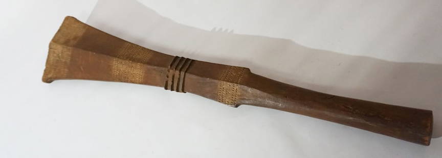
Sold2023Antique 19th Century Malaita Island Supe War ClubPeriod 19th century example Eastern Solomon Islands. Carved nicely and having a very nice patina throughout. L29 1/2" Sold from the collection of a private Charleston, SC gentleman and lady.See Sold Price
Sold2021Boating maps, western New Providence, rose island,Maps from 1981 tropic Isle publishers, Inc By Harry Kline, Western New Providence, rose Island, eastern approaches to Nassau harbour. Size 11“ x 17“See Sold Price
May 09Rail & Road AuctionsSeven 1912 Midwestern Railroad Annual Passes - Chicago & Alton, Illinois Central, Rock Island, New$30
11 hrs LeftJasper521738 RUSSIA SIBERIA & GREAT TARTARY Description illustrated ANTIQUE in ENGLISH$950
4 days LeftTime ArtCanadian Artist Mary Schneider 'Boats in Harbour' (1967) Watercolor PaintingCA$100
4 days LeftJeschke Jadi Auctions Berlin GmbHTanaka, Shihego Fishes of Japan, including Riuiu Islands, Bonin Islands, Formosa, Kurile Islands,€750
2 days LeftJasper52Océanique. Partie de l'ile de Java #27 Bali Lombok Sumbawa VANDERMAELEN 1827 map$260
May 12Eastern Art Auction HouseQianlong Year, Ten Liang Treasure Silver Ingots from Changshan County$200
May 12Eastern Art Auction HouseA Pair Of Cloisonne Vase With Double Elephant Ears Flower Pattern$1,000


![Eastern Siberia [Includes Kamtchatka]: Title/Content of Map: Eastern Siberia [Includes Kamtchatka] Cartographer: WALKER, J. & C./LUTKE/PIADISCHEV Date: 1852 Publisher: CHARLES KNIGHT/GEORGE COX/S.D.U.K. Size: 12.75Height - 15.5Width "Publi](https://p1.liveauctioneers.com/5584/171770/86526676_1_x.jpg?height=310&quality=70&version=1592950942)


![J.B. Hartranft Oil on Canvas, Sailboat: Framed oil on canvas by an eastern Long Island artist, Joseph B. Hartranft, signed lower left. [Art: 20" x 24"; Frame: 25 1/2" x 30"]. Overall good condition.](https://p1.liveauctioneers.com/1221/76402/40103804_1_x.jpg?height=310&quality=70&version=1439495671)