Sold2018England & Wales (Section 6) [Cornwall And SouthwestTitle/Content of Map: England & Wales (Section 6) [Cornwall And Southwest England] Date Printed: 1890 Cartographer: BARTHOLOMEW, JOHN & CO. Size: 11.5X16.25 "By J. Bartholomew, F.R.G.S." 17 Two insetsSee Sold Price
Sold2021Glasgow School Arts & Crafts Copper VaseGlasgow School Arts and Crafts period repousse hammered copper vase with floral motif and square base, unmarked, likely J. F. Pool of Hayle, Cornwall England. 6.5" H x 2.75" Square. Provenance: RemoveSee Sold Price
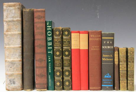
Sold2017LOT OF (13) VINTAGE NOVELS, INCLUDING OLD ENGLISHDante's Inferno, The Life of Marie Antoinette, an Old English book (title is worn off of spine) about History of England, Scotland, Wales and CornwallSee Sold Price
Sold2021England IVPublication Date: 1830-06-15 Title: England IV Cartographer: WALKER, J. & C. Publisher: Baldwin & Cradock/S.D.U.K. Height: 10.25 Width: 15 Southwest England, Cornwall, Devonshire, etc. Called "South-WSee Sold Price
Sold2023(BRITAIN and IRELAND.) Perrier; and George Philip & Son. Group of 3 large color-printed(BRITAIN and IRELAND.) Perrier; and George Philip & Son. Group of 3 large color-printed advertisement "Motor Maps". [England and Wales]. 2 sections, 28½x46 inches each, segmented and mounted to oSee Sold Price
Sold2022Britain.- Mavor (William Fordyce) British Tourists; or, Traveller's Pocket Companion throughBritain.- Mavor (William Fordyce) British Tourists; or, Traveller's Pocket Companion through England, Wales, Scotland, and Ireland, 6 vol., third edition, engraved frontispieces and hand-coloured mapsSee Sold Price
Sold2017Cowperthwait: Map of England and Wales, 1850Title: Map of England and Wales by Thomas Cowperthwait Dimensions (inches): 13.6 x 17.2 Medium: Hand Colored Lithograph Condition: Good Condition Please note that this lot has a confidential reserve.See Sold Price
Sold2023GROUP OF FOUR STAFFORDSHIRE FIGURES INC.. QUEEN OF ENGLAND AND PRINCE OF WALES 17 X 7 X 6 LARGESTGROUP OF FOUR STAFFORDSHIRE FIGURES INC.. QUEEN OF ENGLAND AND PRINCE OF WALES 17 X 7 X 6 LARGESTSee Sold Price
Sold2018ENGLAND & WALES NORTH. Railways companies canals coachTITLE/CONTENT OF MAP: 'General Railway map-Northern Section; Inset map of Manchester' This map is folding hence the centrefold line may show on the image below DATE PRINTED: 1903 IMAGE SIZE: Approx 44See Sold Price
Sold2018Bartholomew: Antique Map of England & Wales, 1890Title/Content of Map: England & Wales Date Printed: 1890 Cartographer: BARTHOLOMEW, JOHN & CO. Size (inches): 11.25X11.6 "By J. Bartholomew, F.R.G.S." Polar projection. 11 Shows nautical routes. FromSee Sold Price
Sold2022Burlington 1779 St. Michaels Mount, Cornwall ShipsFolio Copper Plate Published 1779 by J. Cooke, London for "The Modern Universal British Traveller or, a New, Complete, and Accurate tour Through England, Wales, Scotland, and the Neighbouring Islands"See Sold Price
Sold2022Dugdale & Archer C1840 Lot of 6 British County MapsSteel Engraved Maps with outline hand color Published C1835-60 London for "Curiosities of Great Britain. England & Wales Delineated..." by Thomas Dugdale. Drawn and Engraved by John Archer. Paper SizeSee Sold Price
Sold2019Maps 19th Cent. Mixed Lot of 6Lot of 6 Steel Engraved Maps. Incl Persia, Holy Land, Battle of Alma, Scotland, and England/Wales. Examples by Chambers, SDUK, William Collins, Weller and Rapkin. Paper Size: Up to 16 x 13.5 inch (40See Sold Price
Sold2022Dugdale & Archer C1840 Lot of 6 British County MapsSteel Engraved Maps with outline hand color Published C1835-60 London for "Curiosities of Great Britain. England & Wales Delineated..." by Thomas Dugdale. Drawn and Engraved by John Archer. Paper SizeSee Sold Price
Sold2022Times Atlas 1895 Mixed Lot of 6 Large MapsIncl Mediterranean, England/Wales, Italy, Balkans, Scotland and South America. Lithograph Map Published 1895, London for "The Times Atlas" Centre fold as published. Paper Size: Mostly 21 x 16 inch (53See Sold Price
Sold2022Times Atlas 1895 Mixed Lot of 6 Large MapsIncl Africa North East, Hannover/Schleswig-Holstein, England/Wales, Europe, Austrian Alps, and Asia, Lithograph Map Published 1895, London for "The Times Atlas" Centre fold as published. Paper Size: 2See Sold Price
Sold2021Dugdale, Thomas C1840 Lot of 6 British MapsSteel Engraved Maps Published C1835-60 London for "Curiosities of Great Britain. England & Wales Delineated..." by Thomas Dugdale. Centre fold as issued. Maps Drawn & Engraved by J. Archer. Paper SizeSee Sold Price
Sold2022Dugdale & Archer C1840 Lot of 6 Welsh County MapsSteel Engraved Maps with outline hand color Published C1835-60 London for "Curiosities of Great Britain. England & Wales Delineated..." by Thomas Dugdale. Drawn and Engraved by John Archer. Paper SizeSee Sold Price
Sold2021Dugdale, Thomas C1840 Lot of 6 British MapsSteel Engraved Maps Published C1835-60 London for "Curiosities of Great Britain. England & Wales Delineated..." by Thomas Dugdale. Centre fold as issued. Maps Drawn & Engraved by J. Archer. Paper SizeSee Sold Price
Sold2021Maps 19th Cent. Mixed Lot of 6 MapsIncl Rome, Rio de Janeiro, England/Wales, Europe in the 7th/9th/12th century, Physical Map of Europe, and France. Examples by Fullarton and Chambers. Six sheets containing 8 maps (Two of the ChambersSee Sold Price
Sold2022England & Wales.- Lewis (Samuel) A Map of England andNO RESERVE England & Wales.- Lewis (Samuel) A Map of England and Wales, Divided into Counties, Parliamentary Divisions, & Dioceses, presented in four sections, covering the North East, South East, NorSee Sold Price
Sold2021England And Wales.Map #: 5152 Publication Date: c1885 Title: England And Wales. Cartographer: STANFORD, EDWARD Publisher: EDWARD STANFORD Height: 26.6 Width: 22.6 Scale... 16 miles to 1 inch. ... London atlas series. SSee Sold Price
Sold20181854 Dower Map of England and Wales -- England andReserve Reduced! Title/Content of Map: 1854 Dower Map of England and Wales -- England and Wales Date: 1854, London Cartographer: J Dower Size: 10.1 X 8.6 in. A rather nice map of England and Wales, wiSee Sold Price
Sold2020Bowles, Carrington 1782 Road Map. Devon, CornwallShowing Dorchester, Axminster, Bridport, Falmouth, Truro etc. Copper Engraved Map Published 1782, London for "Bowles's Post-chaise Companion, Or, Travellers Directory Through England and Wales" by CarSee Sold Price
5 days LeftClaydon Auctioneers LtdBooks: Six books from the The New Naturalist series to include The Sea Shore by C. M. Yonge, 1949;£30
May 10Rail & Road AuctionsSeven Pieces of Steamship Silver and China - Detroit & Cleveland, New England, New South Wales, and$40
2 days LeftStanton's Auctioneers & RealtorsAntique Oak Keystone Slide Cabinets & Stereoscope Cards$250
10 hrs LeftThe Benefit Shop Foundation Inc.Vtg Kensington Ye Olde Cottage Ceramic Jar England$15(2 bids)
10 hrs LeftThe Benefit Shop Foundation Inc.19 Cocktail Picks & Forks, S Samran Thai, England$15(3 bids)
BonhamsJOHN WILLIAM CASILEAR (American, 1811-1893) Housatonic River at Cornwall framed 42.5 x 63.0 x 6....$6,500(23 bids)


![England & Wales (Section 6) [Cornwall And Southwest: Title/Content of Map: England & Wales (Section 6) [Cornwall And Southwest England] Date Printed: 1890 Cartographer: BARTHOLOMEW, JOHN & CO. Size: 11.5X16.25 "By J. Bartholomew, F.R.G.S." 17 Two insets](https://p1.liveauctioneers.com/5584/121580/61869452_1_x.jpg?height=310&quality=70&version=1525825976)


![(BRITAIN and IRELAND.) Perrier; and George Philip & Son. Group of 3 large color-printed: (BRITAIN and IRELAND.) Perrier; and George Philip & Son. Group of 3 large color-printed advertisement "Motor Maps". [England and Wales]. 2 sections, 28½x46 inches each, segmented and mounted to o](https://p1.liveauctioneers.com/199/292695/155230875_1_x.jpg?height=310&quality=70&version=1686763282)


