Sold20231895 Rand McNally Map of New Orleans [verso] Louisiana -- Louisiana [verso] New OrleansTitle: 1895 Rand McNally Map of New Orleans [verso] Louisiana -- Louisiana [verso] New Orleans Cartographer: Rand McNally Year / Place: 1895, Chicago Map Dimension (in.): 12.4 X 9.4 in. This is a highSee Sold Price
Sold20221898 Rand McNally Map of Louisiana [verso] New Orleans -- Louisiana [verso] New OrleansTitle: 1898 Rand McNally Map of Louisiana [verso] New Orleans -- Louisiana [verso] New Orleans Cartographer: Rand McNally Year / Place: 1898, Chicago Map Dimension (in.): 12.4 X 9.4 in. This is a highSee Sold Price
Sold2018Rand McNally: Antique Maps of New Orleans/LouisianaTitle/Content of Map: 1895 Rand McNally Maps of New Orleans and Louisiana -- New Orleans [verso] Louisiana Date Printed: 1895, Chicago Cartographer: Rand McNally Size: 11.5 x 9 in. Very nice and highlSee Sold Price
Sold2021A GROUP OF TWO MAPS, LOUISIANA AND NEW ORLEANS, EARLYA GROUP OF TWO MAPS, LOUISIANA AND NEW ORLEANS, EARLY 20TH CENTURY, comprising, "The RAND-McNALLY New Commercial Atlas Map of New Orleans," 1912, page 238, from Commercial Atlas Map of America, a reisSee Sold Price
Sold2020New Orleans 1896Title/Content of Map: New Orleans 1896 Date Printed: 1896 Material/Medium: paper Size: approx. 10.5x 13.5 inches Additional Info: Rand McNally & Co. Universal Atlas of the World Reserve: $25.00 ShippiSee Sold Price
Sold20211895 Rand McNally Map of New York City [verso] BrooklynTitle: 1895 Rand McNally Map of New York City [verso] Brooklyn -- Map of the Southern Portion of New York City [verso] Brooklyn Cartographer: Rand McNally Year / Place: 1895, Chicago Map Dimension (inSee Sold Price
Sold20201876 Gray Map of Louisiana with New Orleans Inset VersoTitle/Content of Map: 1876 Gray Map of Louisiana with New Orleans Inset Verso Mississippi -- Louisiana [verso] Mississippi Date: 1876, Philadelphia Cartographer: O Gray Size: 12 X 14.8 This is a verySee Sold Price
Sold20181896 Rand McNally Map of Texas and Indian TerritoryTitle/Content of Map: 1896 Rand McNally Map of Texas and Indian Territory/Oklahoma -- Texas [verso] Oklahoma and Indian Territory Date Printed: 1896 Chicago Cartographer: Rand McNally Size: 9.2 x 12.5See Sold Price
Sold2021New Orleans 1900Title/Content of Map: New Orleans 1900 Date Printed: 1900Material/Medium: Paper Size: 11x14 inches Rand McNally prepared for The Public Ledger, Philadelphia Reserve: $30.00 Shipping: Domestic: Flat-See Sold Price
Sold2021McNally & Co.'S New Business Atlas Map of Louisiana.Title: McNally & Co.'S New Business Atlas Map of Louisiana. Cartographer: RAND, MCNALLY & CO. Publisher: RAND, MCNALLY & CO. Height: 19 Width: 26 From Rand, McNally & Co.'s Enlarged Business atlas ...See Sold Price
Sold2020New Mexico 1896Title/Content of Map: New Mexico 1896 Date Printed: 1896 Material/Medium: paper Size: approx. 10.5x 13.5 inches Additional Info: Rand McNally & Co. Universal Atlas of the World Reserve: $25.00 ShippinSee Sold Price
Sold2020New Jersey 1896Title/Content of Map: New Jersey 1896 Date Printed: 1896 Material/Medium: paper Size: approx. 11x 14 inches Additional Info: Rand McNally & Co. Universal Atlas of the World Reserve: $20.00 Shipping: DSee Sold Price
Sold2021Railway Terminal Map of ChicagoRailway Terminal Map of Chicago, signature to the middle right reads ‘RAND, McNALLY & CO’s New. Railway Terminal Map of Chicago, copyright by Rand McNally & Co.’’, verso reads ‘A.I. FriedmanSee Sold Price
Sold2019Three Maps by Samuel Augustus Mitchell (1790-1868), "Three Maps by Samuel Augustus Mitchell (1790-1868), " County Maps of Arkansas, Louisiana and Mississippi, Verso with Florida, and a Plan of New Orleans" 1882, hand colored, on two pages, H.-24 in., W.See Sold Price
Sold2018U.S Coast Survey 1857 Map. New Orleans, Louisiana"Sketch II Showing The Progress of the Survey in Section No. VIII" A Rare Map centred on New Orleans and Lake Pontchartrain. Also showing Bon Secours Bay (Alabama) Isle au Breton Sound and Vermilion BSee Sold Price
Sold2018U.S Coast Survey 1856 Map. New Orleans, Louisiana"Sketch II Showing The Progress of the Survey in Section No. VIII" A Rare Map centred on New Orleans and Lake Pontchartrain. Also showing Bon Secours Bay (Alabama) Isle au Breton Sound and Vermilion BSee Sold Price
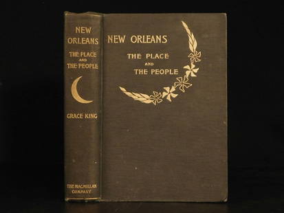
Sold20181896 1ed New Orleans Louisiana Colonization Creole1896 1ed New Orleans Louisiana Colonization Creole Native Americans Mardi Gras Grace King’s ‘New Orleans’ is a late 17th-century historical account of the famous Louisiana city. King focuses onSee Sold Price
Sold20191898 Rand McNally Map of Louisiana -- [Louisiana]Title/Content of Map: 1898 Rand McNally Map of Louisiana -- [Louisiana] Date: 1898 Chicago Cartographer: Rand Mcnally Size: 13 X 19.4 in. This is a highly detailed, larger map of Lousiana. It color coSee Sold Price
Sold20191893Crams's Map of New Orleans verso Atlanta -- NewTitle/Content of Map: 1893Crams's Map of New Orleans verso Atlanta -- New Orleans verso Atlanta Date: 1893, New York Cartographer: G Cram Size: 11.3 X 9.4 in. Very nice maps showing streets, steam / hSee Sold Price
Sold20181891 Watson Cram Map of New Orleans, Verso AtlantaTitle/Content of Map: 1891 Watson Cram Map of New Orleans, Verso Atlanta -- New Orleans verso Atlanta1891, Chicago Cartographer: G Cram / Watson & Co Size: 11.3 X 9.4 in. Very nice maps showing streetSee Sold Price
Sold20221892 Rand McNally map of Louisiana -- LouisianaTitle: 1892 Rand McNally map of Louisiana -- Louisiana Cartographer: Rand McNally Year/Place: 1892, Chicago Dimensions: 9.7 X 12.8 in. Description: An attactive and highly detailed colored map of LouiSee Sold Price
Sold2019U S Coast Survey 1896 LG Map. New Orleans Texas Florida"Sketch of General Progress June 30. 1896" Showing Southern, Eastern and Mid West States, incl Florida, Texas, Gulf of Mexico, Georgia etc. Large Lithograph Map Published 1896, Washington for "U.S. CoSee Sold Price
Sold2017Cram: Antique Map of New Orleans, 1889Map: 1889 Cram's Map of New Orleans verso Map of San Francisco -- New Orleans verso San Francisco Cartographer: G Cram / People's Publishing Co. Year / Place: 1889, New York Map Dimensions: 11.3 X 9.4See Sold Price
Sold20171886 Crams's Map of New Orleans & Atlanta1886 Crams's Map of New Orleans verso Atlanta G Cram / People's Publishing Co. 1886, New York 11.3 X 9.4 in. Very nice maps showing streets, steam / horse roads, ferries, churches, government buildingSee Sold Price
2 hrs LeftJasper521895 Rand McNally Map of New York City [verso] Brooklyn -- Map of the Southern Portion of New York$55
May 11Crescent City Auction GalleryBelgian School, "Still Life with Flowers," 20th c., H.- 19 3/4 in., W.- 15 3/4 in., Framed- H.- 29$325
12 hrs LeftRapid Estate Liquidators and Auction GalleryLeather Bound This Is My Country By Felix Jones$30
May 10Rail & Road AuctionsEleven Army Corps of Engineers Port Series No. 1 Through No. 8 Books with Fold Out Maps$35(2 bids)


![1895 Rand McNally Map of New Orleans [verso] Louisiana -- Louisiana [verso] New Orleans: Title: 1895 Rand McNally Map of New Orleans [verso] Louisiana -- Louisiana [verso] New Orleans Cartographer: Rand McNally Year / Place: 1895, Chicago Map Dimension (in.): 12.4 X 9.4 in. This is a high](https://p1.liveauctioneers.com/5584/283091/149355547_1_x.jpg?height=310&quality=70&version=1680038985)
![1896 Rand McNally Map of New Orleans [verso] Louisiana First Image](https://p1.liveauctioneers.com/5584/121886/62056794_1_x.jpg?height=300&quality=1&version=1526425885&width=300)
![1896 Rand McNally Map of New Orleans [verso] Louisiana First Image](https://p1.liveauctioneers.com/5584/121886/62056794_1_x.jpg?height=300&quality=95&version=1526425885&width=300)
![1898 Rand McNally Map of Louisiana [verso] New Orleans -- Louisiana [verso] New Orleans: Title: 1898 Rand McNally Map of Louisiana [verso] New Orleans -- Louisiana [verso] New Orleans Cartographer: Rand McNally Year / Place: 1898, Chicago Map Dimension (in.): 12.4 X 9.4 in. This is a high](https://p1.liveauctioneers.com/5584/244140/126654872_1_x.jpg?height=310&quality=70&version=1650405199)
![Rand McNally: Antique Maps of New Orleans/Louisiana: Title/Content of Map: 1895 Rand McNally Maps of New Orleans and Louisiana -- New Orleans [verso] Louisiana Date Printed: 1895, Chicago Cartographer: Rand McNally Size: 11.5 x 9 in. Very nice and highl](https://p1.liveauctioneers.com/5584/115999/59597438_1_x.jpg?height=310&quality=70&version=1517965830)


![1895 Rand McNally Map of New York City [verso] Brooklyn: Title: 1895 Rand McNally Map of New York City [verso] Brooklyn -- Map of the Southern Portion of New York City [verso] Brooklyn Cartographer: Rand McNally Year / Place: 1895, Chicago Map Dimension (in](https://p1.liveauctioneers.com/5584/208108/105911435_1_x.jpg?height=310&quality=70&version=1624395684)
![1876 Gray Map of Louisiana with New Orleans Inset Verso: Title/Content of Map: 1876 Gray Map of Louisiana with New Orleans Inset Verso Mississippi -- Louisiana [verso] Mississippi Date: 1876, Philadelphia Cartographer: O Gray Size: 12 X 14.8 This is a very](https://p1.liveauctioneers.com/5584/164510/83043392_1_x.jpg?height=310&quality=70&version=1585094571)
![1896 Rand McNally Map of Texas and Indian Territory: Title/Content of Map: 1896 Rand McNally Map of Texas and Indian Territory/Oklahoma -- Texas [verso] Oklahoma and Indian Territory Date Printed: 1896 Chicago Cartographer: Rand McNally Size: 9.2 x 12.5](https://p1.liveauctioneers.com/5584/120548/61369196_1_x.jpg?height=310&quality=70&version=1524013707)


![1898 Rand McNally Map of Louisiana -- [Louisiana]: Title/Content of Map: 1898 Rand McNally Map of Louisiana -- [Louisiana] Date: 1898 Chicago Cartographer: Rand Mcnally Size: 13 X 19.4 in. This is a highly detailed, larger map of Lousiana. It color co](https://p1.liveauctioneers.com/5584/133765/67934968_1_x.jpg?height=310&quality=70&version=1546475054)


![1895 Rand McNally Map of New York City [verso] Brooklyn -- Map of the Southern Portion of New York (1 of 2)](https://p1.liveauctioneers.com/5584/325789/175390127_1_x.jpg?height=282&quality=70&version=1713301948)


![[CIVIL WAR] Black Soldier CDV (1 of 2)](https://p1.liveauctioneers.com/7226/322253/173251672_1_x.jpg?height=282&quality=70&version=1710004847)


