Sold2018Bellin: Hydrographic Chart of Havana BayCartographer: Bellin / Depot de la Marine Place/Date: Paris / 1762 Size: 22 1/4" x 16 1/4" Condition: wash color; overall age toning, repaired tears along edge of upper margin From the Hydrographie FrSee Sold Price
Sold2018Bellin: Hydrographic Chart of Havana BayMap: Carte Hydrographique de la Baye de la Havane. Cartographer: Bellin / Depot de la Marine Place & Date: Paris / 1762/1772 Size: 22 1/4" x 16 1/4" Condition: b&w; some nicks, splits and fraying alonSee Sold Price
Sold2021Bellin/Prevost: Saldanha Bay, South AfricaTitle/Content of Map: Bellin/Prevost: Saldanha Bay, South Africa Date Printed: 1755, Paris Cartographer: Bellin/Prevost Size: 10 3/4" x 8 1/8" Bellin's detailed chart of Saldanha Bay and the LangebaanSee Sold Price
Sold2018Bellin: Antique Map of Portobelo Bay, Panama, 1764Baye de Porto-belo et Costes Voisines Bellin's highly detailed chart of the Bay of Portobello in Panama and its "neighboring coasts" features good topographical and navigational details (shoals, sandbSee Sold Price
Sold2024Rare Antique Map - Hudson Bay Chart - Old Map of North America - Bellin - Jacques"Carte de la Baye de Hudson". Its finely engraved, hand-coloring engraved map from the Dutch edition of acques Nicolas Bellin Histoire "General of Travel". Published in Amsterdam. A handsome chart ofSee Sold Price
Sold2020Bellin: Isla del Carmen (Port Royal Island), MexicoBellin's attractive chart of the island of Port Royal (today Isla del Carmen), the Laguna de Terminos and the surrounding coast of Campeche Bay, with many place names and topographical details, includSee Sold Price
Sold20211921 with 1943 Revision of Hiroshima Bay Nautical ChartTitle: 1921 with 1943 Revision of Hiroshima Bay Nautical Chart -- Japan Naikai or Inland Sea Aki Nada Hiroshima Wan Cartographer: US Hydrographic Office Year / Place: 1921 with 1943 Revision, WashingtSee Sold Price
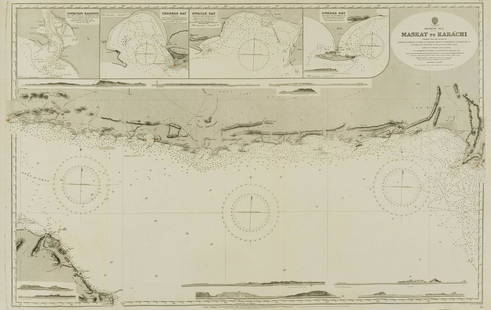
Sold2022Middle East.- Oman.- Admirality Hydrographic Office (The) Maskat to Karachi, engraved chart, 1916.Middle East.- Oman.- Admirality Hydrographic Office (The) Maskat to Karachi, showing the coast from Maskat to Karachi, the Gulf of Oman, with inset maps of Sonmoyani Harbour, Chahbar Bay, Gwatar Bay aSee Sold Price
Sold20181758 Bellin Chart of the Flags of Sea-Going Nations --Title/Content of Map: 1758 Bellin Chart of the Flags of Sea-Going Nations -- Tableau des Pallions que la Pluspart des Nations Arborent a la Mer Date Printed: 1758, Paris Cartographer: J Bellin Size: 1See Sold Price
Sold2018Bellin: Chart of the North Seas/Greenland/ScandinaviaTitle/Content of Map: Carte Reduite des Mers du Nord Cartographer: Bellin Place & Date: Paris / 1758 Size: 18" x 13" Condition: b&w; overall age toning; old folds and wrinkling; one small hole (on NorSee Sold Price
Sold2018Bellin: Chart of the Strait of Magellan 1760Map: Carte Reduite du Detroit de Magellan Cartographer: Bellin Place & Date: Paris / 1753/1760 Size: 13 1/2" x 9" Condition: b&w; old fold; margins extended with contemporary paper to fit the size ofSee Sold Price
Sold2018Bellin: Chart of Santiago de Cuba HarborReserve Reduced! A detailed plan of the harbor of Santiago de Cuba, featuring forts, depth soundings, anchorages, the road from the forts to "la Ville de St. Yago," and a decorative title cartouche, fSee Sold Price
Sold2019Bellin: Chart of Acapulco Harbor, Mexico, 1754Cartographer: Bellin Place/Date: Leipzig / 1754 Size: 5 7/8" x 7 1/2" Condition: b&w; overall age-toning, some spotting, mostly in the margins A simple but detailed plan of the important Spanish PacifSee Sold Price
Sold2017Bellin: Map of the Southern Ocean, 1746Map: Carte de l'Ocean Meridional Cartographer: Bellin Place & Date: Paris / 1746/1760 Size: 18" x 12 1/2" Bellin's chart of the southern Atlantic Ocean, from Prevost d'Exiles' influential collection oSee Sold Price
Sold2020Bellin: Isla del Carmen (Port Royal Island), MexicoTitle/Content of Map: Bellin: Isla del Carmen (Port Royal Island), Mexico Date Printed: 1760, Leipzig Cartographer: Bellin Size: 5 7/8" x 7 7/8" A lovely exemplar of Bellin's chart of the island of PoSee Sold Price
Sold2022Framed Maryland Chesapeake Bay Chart / MapNOAA Chart 12273, Maryland Chesapeake Bay Sandy Point to Susquehanna River. Professionally sealed in frame. Excellent condition. 41"x36.5".See Sold Price
Sold2023NAUTICAL CHART / CHESAPEAKE BAY COVE POINT TO SANDY POINTDescription: United States – East Coast Maryland. NAUTICAL CHART / CHESAPEAKE BAY COVE POINT TO SANDY POINT. Published at Washington D.C/ US Department of Commerce National Oceanic and AtmospheSee Sold Price
Sold2024Cuban Pre-Revolution Casino ChipsIncludes Grand Casino Havana Guantanamo Bay, Oriental Park Racetrack Habana Cuba, St John's Casino, Wilber Clark's Casino, Habana Hilton Casino, Casino Comodoro, Madrid Casino, Sans-Souci, Plaza CasinSee Sold Price
Sold2016(2) ANTIQUE IRELAND MAPSCarte D' Irlande map published in 1867 by Alvin J. Johnson New York. Measures 10 3/4" x 15 3/4" (Framed 19 1/2" x 23 1/2") and a Jacques Nicolas Bellin A Chart of Ireland 1803 hand colored map. MeasurSee Sold Price
Sold2017Bellin: Antique Map Plan of Portobello, Panama, 1756Map: Plan de la Baye et Ville de Portobelo en 1736 Cartographer: Bellin Place & Date: Paris / 1756 Size: 12 7/8" x 7 5/8" Condition: b&w; overall age toning; with folds as issued Bellin's detailed chaSee Sold Price
Sold2021"GEO. W. ELDRIDGE'S CHART G PENOBSCOT BAY TO MACHIAS""GEO. W. ELDRIDGE'S CHART G PENOBSCOT BAY TO MACHIAS"Dated 190130.5” x 51” sight. Framed 34.75” x 57.75”.See Sold Price
Sold20161800's Chart Showing Penobscot Bay, MaineOriginal coastal survey from 1880 detailing Penobscot Bay from Belfast to Thomaston and as far east as Deer Isle. Mounted in a silver frame. Top of chart has minor loss. Overall Dimensions: 48" H x 40See Sold Price
Sold2022Framed Corpus Christi Bay Nautical ChartCorpus Christi nautical chart, 4th ed., dated "May / 10" marked by the National Oceanic and Atmospheric Administration (NOAA), United States Coast and Geodetic Survey height 39 in. x width 49See Sold Price
Sold20231776 Joshua Fisher A Chart of Delaware Bay and River1776 Joshua Fisher Philadelphia- A Chart of Delaware Bay and River 7 1/2 x 9 1/2 in matt.See Sold Price
4 days LeftCutler Bay AuctionsMarta Maria Perez Bravo (Born 1959) "No matar ni ver matar Animales"$1,600
4 days LeftCutler Bay AuctionsPedro Pablo Oliva (Born 1949) "Las Hermosas Tardes de Rosa y Francisco"$3,000
4 days LeftCutler Bay AuctionsVictor Manuel (1897 - 1969) “Muchacha con Manto Azul " Latin American$6,000
4 days LeftCutler Bay AuctionsSecundino (Cundo) Bermúdez "Maria Amenazada" (1914-2008) Latin American$500