Sold2020Mappemonde en Deux Hemispheres Conrad Malte-Brun 1846Antique Map 'Mappemonde en Deux Hemispheres' [World Map in Two Hemispheres] by Conrad Malte-Brun (1775 - 1826) | DATE: c. 1846 | SIZE: Map with borders: Approx. 16" H x 22" W (40.64 x 55.88cm); imageSee Sold Price
Sold2017Malte-Brun: Antique Map of Portugal & Spain, 1812Title/Content of Map: Portugal with parts of Western Spain Date Printed: 1812 Cartographer: Malte-Brun Material/Medium: Paper Size: 10" x 13 1/2" Published in Paris Conrad Malte-Brun (1775 - 1826), boSee Sold Price
Sold2017Thierry Malte-Brun: Antique Map of England, 1834Title: Map of Angleterre by Thierry Malte-Brun Date: c 1834 Medium: Hand Colored Lithograph Dimensions (in.): 10.75 x 16.5 Conrad Malte-Brun (1775 - 1826), born Malthe Conrad Bruun, and sometimes refeSee Sold Price
Sold2018Map of Mongol Empire Coloured by Hand 1842 Malte-BrunMap of Mongol Empire Coloured by Hand 1842 Malte-Brun Etching On Steel 1842 Malte-Brun Conrad (1775-1826) etching on steel Leaf Dimension: 32x25,5 cm (12.6x10.04 inches)Engraving Dimension: 26x20 cm (See Sold Price
Sold20173 Vol Universal Geography/Description of the World 1824Volumes 1-3 Book Title: Universal Geography or a Description of All Parts of the World Author: M. Malte-Brun Publishing: Boston, Wells and Lilly, 1824 Conrad Malte-Brun (1775-1826) born Malthe ConradSee Sold Price
Sold20181850 MAPS Atlas Geography Illustrated Jerusalem CHINA1850 MAPS Atlas Geography Illustrated Jerusalem CHINA 8v Malte-Brun Conrad Malte-Brun was a French geographer and cartographer known for his impressive journal-like atlases and geography books. UnfortSee Sold Price
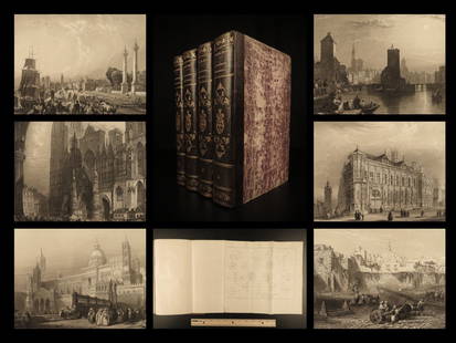
Sold20221841 BEAUTIFUL Geography by Malte-Brun Illustrated1841 BEAUTIFUL Geography by Malte-Brun Illustrated Jerusalem Edinburg Ruins 4v Conrad Malte-Brun was a French geographer and cartographer known for his impressive journal-like atlases and geography boSee Sold Price
Sold20191843 Geography WORLD VIEWS Atlas Illustrated Jerusalem1843 Geography WORLD VIEWS Atlas Illustrated Jerusalem Israel India 6v Malte-Brun Conrad Malte-Brun was a French geographer and cartographer known for his impressive journal-like atlases and geographySee Sold Price
Sold2017Malte-Brun: Map of Asia, 1830Map: Asia Maker: John Grigg, Malte-brun, Conrad/j. H. Young, Sc. Publication Date: 1830 Publisher: John Grigg Size: Quarto – 8.00 H x 9.75 W Inches From Malte-Brun's "A new General atlas, exhibitingSee Sold Price
Sold2022Cortambert french Africa map 1864 engraving hand coloredEugene Cortambert (french, 1805-1881): french Africa map, copper hand colored engraving, from Geographie Universelle de Malte-Brun published in 1864 in Paris by Boulanger & Legrand.24" X 19”.DimSee Sold Price
Sold2018Malte-Brun: Antique Map of Central Oceanica, 1830Title/Content of Map: Central Oceanica Date Printed: 1830 Cartographer: MALTE-BRUN, CONRAD/J. H. YOUNG, sc. Size (inches): 7.5x7.5 From Malte-Brun's "A new General atlas, exhibiting the five great divSee Sold Price
Sold2017John Grigg: Map of North America, 1830Map: North America Maker: John Grigg, Malte-brun, Conrad/ J. H. Young Date: 1830 Size: Quarto, 9.8 inches high x 8 inches wide From Malte-Brun's "A new General atlas, exhibiting the five great divisioSee Sold Price
Sold2017John Grigg: Map of Western States & Territories, 1830Map: Western States & Territories Maker: John Grigg, Malte-brun, Conrad/ J. H. Young Date: 1830 Size: Quarto, 9.75 inches high x 8 inches wide From Malte-Brun's "A new General atlas, exhibiting the fiSee Sold Price
Sold20171812 Malte-Brun Map of Siberian and Alaskan RussiaTitle: 1812 Malte-Brun Map of Siberian and Alaskan Russia -- Siberie avec lAmerique RussePartie Meridionale de la Russie d'Europe Cartographer: M Malte-Brun Origin/Date: 1812, Paris Size: 8.7 inches XSee Sold Price
Sold2017Malte-Brun: Map of Europe, Barbarian Invasions, 1811Map: 1811 Malte-Brun Map of Europe during the Barbarian Invasions -- L'Europe apres l'invasion des Barbares Cartographer: M Malte-Brun Year / Place: 1811, Paris Map Dimensions: 8.7 X 11.7 An outstandiSee Sold Price
Sold20171834 Malte-Brun Map of Ireland1834 Malte-Brun Map of Ireland -- Ireland. M. Malte-Brun / S. Walker. 1834, Boston. 9.3 x 7.5 in. An attractive and highly detailed map with topographical and settlement details. From the American ediSee Sold Price
Sold2017Malte-Brun: Map of Europe during Hun invasion in 370Map: 1812 Malte-Brun Map of Europe during the Hun invasion in 370 -- L'Europe avant l'invasion des Huns vers l'an 370 Date Printed: 1812, Paris Cartographer: M Malte-Brun Size: 8.7 X 11.7 in. ConditioSee Sold Price
Sold20171812 Malte-Brun Map of the Known WorldTitle: 1812 Malte-Brun Map of the Known World -- Systemes Geographiques de Ptolemee… Cartographer: M Malte-Brun Origin/Date: 1812, Paris Size: 8.7 inches X 11.7 inches An excellent and very interestSee Sold Price
Sold2017Malte-Brun Map of the Spice Islands, 18341834 Malte-Brun Map of the Spice Islands -- East India Islands (S China Sea). An attractive and highly detailed map the East India Islands with topographical and settlement details. From the AmericanSee Sold Price
Sold20201812 Malte-Brun Map of Ancient Civilized World -- MondeTitle/Content of Map: 1812 Malte-Brun Map of Ancient Civilized World -- Monde Connu des Anciens Cartographer: M Malte-Brun Year/Place: 1812, Paris Size: 8.7 X 11.7 in. An excellent map showing the geoSee Sold Price
Sold20191812 Malte-Brun Map of Germany -- Confederat du RhinTitle/Content of Map: 1812 Malte-Brun Map of Germany -- Confederat du Rhin Date: 1812, Paris Cartographer: M Malte-Brun Size: 11.7 x 8.8 in. An attractive map of German states, showing its political dSee Sold Price
Sold20181834 Malte-Brun Map of Asia -- AsiaTitle/Content of Map: 1834 Malte-Brun Map of Asia -- Asia Date Printed: 1834, Boston Cartographer: M. Malte-Brun / S. Walker Size: 9.3 x 7.5 in. An attractive and highly detailed map with topographicaSee Sold Price
Sold20201812 Malte-Brun Map of Scandinavia -- Danemark Suede etTitle/Content of Map: 1812 Malte-Brun Map of Scandinavia -- Danemark Suede et Norwege Cartographer: M Malte-Brun Year/Place: 1812, Paris Size: 11.7 x 8.8 in. A handsome map of Scandinavia. Finland isSee Sold Price
Sold20181834 Malte-Brun Map of Scotland -- ScotlandTitle/Content of Map: 1834 Malte-Brun Map of Scotland -- Scotland Date: 1834, Boston Cartographer: M. Malte-Brun / S. Walker Size: 9.3 x 7.5 in. An attractive and highly detailed map with topographicaSee Sold Price
2 days LeftFreeman's | HindmanCamille Pissarro (Danish/French, 1830-1903) La Maison Rondest, à l'Hermitage, 1882$400(1 bid)
2 days LeftFreeman's | HindmanCamille Pissarro (Danish/French, 1830-1903) Vue de Rouen (Cours la Reine), 1884$400
191 Lots AwayFreeman's | HindmanFrederick Stanton Perkins (American, 1832-1899), after Élisabeth Louise Vigée Le Brun$500
4 days LeftJeffrey S. Evans & AssociatesFRANCOIS NICOLAS AUGUSTE FEYEN-PERRIN (FRENCH, 1826-1888) OLD MASTER-STYLE PAINTING$70(1 bid)
May 12Schilb Antiquarian Rare Books1844 Siege of Gibraltar American Revolution SPAIN France Drinkwater MAP History$1(1 bid)
Featured1 day LeftJasper52Erik Reiff (1923-2006), Erik Reiff was a Danish ceramist and painter. After training in Denmark and$500
May 16Potter & Potter AuctionsAUDIBERTI, J. Choain. Afrique Equatoriale Francaise. Paris:...$100(1 bid)
5 days LeftHobby Dealer(5) 1977 Germany, 1954 France, 1971 Denmark, 1972 Philippines, 1990 Netherlands$4
BonhamsLouis XVI Marble-top Mahogany Commode, Ferdinand Bury (1740-95; maître 1774), Paris, France...$1,500


![Mappemonde en Deux Hemispheres Conrad Malte-Brun 1846: Antique Map 'Mappemonde en Deux Hemispheres' [World Map in Two Hemispheres] by Conrad Malte-Brun (1775 - 1826) | DATE: c. 1846 | SIZE: Map with borders: Approx. 16" H x 22" W (40.64 x 55.88cm); image](https://p1.liveauctioneers.com/6084/186772/93903861_1_x.jpg?height=310&quality=70&version=1606446047)