Sold20181743 Le Rouge Map of the German Empire -- L'EmpireTitle/Content of Map: 1743 Le Rouge Map of the German Empire -- L'Empire d'Allemagne de die a Monseigneur a Melot ministre a Secretaire d'Etal par le Rouge a Paris... Date: 1743, Paris Cartographer: GSee Sold Price
Sold2016Map of German Empire 1788Heading: Author: Dezauche, J.A. Title: L'Allemagne dressee sur les Observations de Tycho Brahe de Kapler de Suellius… Place Published: Paris Publisher: Date Published: 1788 DescriptionSee Sold Price
Sold2022Popple, Henry,(Britain, 16?? - 1743) A Map of The British Empire in America with French, Spanish and(d. 1743) Printed In Amsterdam For L Covens And C. Mortier c.1755, Sight View 19" x 18-1/2", Overall 21" x 26" "Carte Particuliere de l'Amerique Septentrionale."See Sold Price
Sold2020Grp: 7 Maps of IndiaGroup of seven maps of India. Includes two hand colored maps by Pierre Duval (1618-1683), "Presquisle de L'Inde de ca le Gange" and "Empire Du Mogol"; three maps by Girolamo Ruscelli (1500-1566), "TabSee Sold Price
Sold20191743 Le Rouge Map of Southern Poland and parts of CzechTitle/Content of Map: 1743 Le Rouge Map of Southern Poland and parts of Czech Republic (Silesia) -- Le Duche De Silesie divse en XVII Principautees . . . Date: 1743, Paris Cartographer: G Le Rouge SizSee Sold Price
Sold20191743 Le Rouge Map of Southern Czech Republic (Moravia)Title/Content of Map: 1743 Le Rouge Map of Southern Czech Republic (Moravia) -- Le Marquisat de Moravie par et Chez le St. le Rouge ingenieur Geogrephe du Roy Rue des Augustins a Paris 1743 Date: 1743See Sold Price
Sold2018Santini/Vaugondy: Antique Map of Empire of Japan, 1784TITLE/CONTENT OF MAP: 'l'Empire du Japon divisé en sept principales parties, savoir, Ochio, Quanto, Jetsegen, Jetsen, Jamaisoit, Xicoco et Ximo, et subdivisé en soixante et six Royaumes, par les Sr.See Sold Price
Sold20211796 Josephe de Laporte map of China1796 Josephe de LaPorte hand colored map "L'Empire de la Chine avec les Isles Du Japon et la Coree", sight 7 1/4" x 8 3/4", well framed, overall 12" x 14"See Sold Price
Sold2017Bellin: Antique Map of Chinese Empire, 1748Map: L'Empire de la Chine Cartographer: Bellin Place & Date: Paris / 1748/1760 Size: 15 5/8" x 11 1/4" Condition: outline color; old folds; overall age toning; a light water stain in the right marginSee Sold Price
Sold2019LEmpire du Mogol et la PresquIsle de llnde en decà duTITLE/CONTENT OF MAP: 'LEmpire du Mogol et la PresquIsle de llnde en decà du Gange [The Mughal Empire and the Indian subcontinent below the Ganges]' The top image on the right hand side shows the entSee Sold Price
Sold2017Bellin: Map of L'Empire de la Chine, 1748L'Empire de la Chine. Bellin's superbly rendered map of the Empire of China and the Kingdom of Korea, with good topographical detail, many place names, and three elaborate cartouches, from Prevost d'ESee Sold Price
Sold2018Carte De L'empire De Russie Dressee Par J.B.Title/Content of Map: Carte De L'empire De Russie Dressee Par J.B. Poirson...1826 Date: 1826 Cartographer: POIRSON, JEAN BAPTIST (1760-1831) Size: 31x22 Dissected and laid down on brown cloth. Shows ESee Sold Price
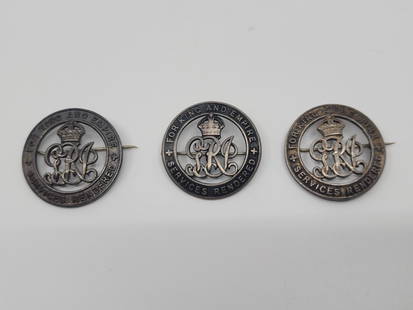
Sold2022Set of 3 Services Rendered For King and Empire Sterling Silver Pin'sTitle : Set of 3 Services Rendered For King and Empire Sterling Silver Pin's Description (FR) : Ensemble de 3 epinglettes en argent sterling pour service rendu pour le roi et l'empire de l'armee CanadSee Sold Price
Sold2017Bellin: Antique Map of Tartary, Tibet, Silk-Road ChinaMap: Carte de l'Empire de Hya et Partie de Tangut Cartographer: Bellin Place & Date: Paris / 1749/1760 Size: 12 1/8" x 8 5/8" Condition: outline color; overall age toning, some minor spotting, and a lSee Sold Price
Sold2017Map of German Empire East Sheet, 1885Map: German Empire East Sheet German Empire East Sheet From Black's General Atlas of the World New and Revised Edition. Edinburgh 1885 Size: 12.25 x 17.25 inches No Reserve: This lot starts at $1 andSee Sold Price
Sold2017Bellin: Map of Central Mexico, 1758Map Title: 'Carte de l'Empire du Mexique Pour l'Histoire Générale des Voyages 1754 par M. B. Ing. de la Marine' Date: 1758 Image Size: Approx 22.5 x 31.0cm, 8.75 x 12.25 inches (Large) Type: AntiqueSee Sold Price
Sold2021L' Empire Du Japon MapRobert de Vaugondy, Venice: Santini, 1778 19" x 22" (sight) hand-colored engraved map framed- 28" x 31"See Sold Price
Sold20221750 Robert de Vaugondy Map of Russian Empire -- PartieTitle: 1750 Robert de Vaugondy Map of Russian Empire -- Partie Occidentale de l'Empire de Russie, ou se Trouve Distinguee la Russie Europeenne… Cartographer: D Robert de Vaugondy Year/Place: 175See Sold Price
Sold2015A map of China, Korea and the Japanese Isles, ca. 1779SANTINI, Paolo, L'Empire de la Chine, avec la Tartarie Chinoise d'aprs l'Atlas Chinois. Venice, Remondini, 1779. Original outline colour. 485 x 560mm. China, Korea and Tartary, also showing Japan andSee Sold Price
Sold2016Napoleon's Pocket Map of Europe. 1811-12Carte des Routes des Postes de l'Empire Francais du Royaume de l'Italie et de la Confederation du Rhin. Tardieu, gravieur des postes Imperiales, 1812. Approximately 50 x 56 1/4 inches, color outlSee Sold Price
Sold2024De Vaugondy map of ChinaHeading: (China) Author: Robert de Vaugondy, Gilles and Didier Title: L'Empire de la Chine dressé d'après les Cartes de l'Atlas Chinois Place Published: [Paris] Publisher: Date Published: 1See Sold Price
Sold2022Large Antique French map GERMAN EMPIRE 1792 colored by POIRSON engraver BassetJean-Baptiste Poirson is an engineer-geographer and cartographer. Born in Vrécourt (Vosges) on March 6, 1761, he studied mathematics, geography and followed an engineering career. Under the direcSee Sold Price
Sold20211750 Robert de Vaugondy Map of Russia in Large Part --Title: 1750 Robert de Vaugondy Map of Russia in Large Part -- Partie Occidentale de l'Empire de Russie ou se trouve distinguee la Russie Europeenne … Cartographer: D Robert de Vaugondy Year / Place:See Sold Price
Sold2023MAP, China & Korea, BellinChina & Korea. Jacques Nicolas Bellin, L'Empire de la Chine pour Servir a l'Histoire Generale des Voyages, from Histoire Generale des Voyages, 1748 (dated). Hand Color. Attractive and detailed map ofSee Sold Price
6 hrs LeftJasper52Carte L’Asie. Asia. Mughal Empire. Oirat Kingdom. Tartary. VAUGONDY 1750 map$280
6 hrs LeftJasper52Les Environs de Londres à sept Lieues à la Ronde… London. LE ROUGE 1745 map$420
6 hrs LeftJasper52Empire du Japon divisée en sept principales parties. Japan. DE VAUGONDY 1750 map$260
3 days LeftJeschke Jadi Auctions Berlin GmbHDenham u. Hugh Clapperton, Dixon Voyages et découvertes dans le nord et dans les parties€200
6 days LeftJasper521700 Schenk Map of Russian Empire -- La Russie Blanche ou Moscovie Divisee Suivant l'Estendue des$240
5 days LeftL'Autographe LtdHISTORY - BONAPARTE Joseph (1768 - 1844) - Autograph letter signed£200(1 bid)
5 days LeftL'Autographe LtdHISTORY - BONAPARTE Napoleon III (1808 - 1873) - Autograph letter signed£400
5 days LeftL'Autographe LtdHISTORY - THIERS Louis Adolphe (1797 - 1877) - Autograph letter signed£100
5 days LeftL'Autographe LtdHISTORY - MONCEY Bon Adrien JEANNOT de (1754 - 1842) - Autograph letter signed£240
5 days LeftL'Autographe LtdHISTORY - D'HAUSSONVILLE Joseph (1809 - 1884) - Autograph letter signed£50
5 days LeftL'Autographe LtdHISTORY - GALLIFFET Gaston Auguste (1830 - 1909) - Autograph letter signed£50
5 days LeftL'Autographe LtdHISTORY - D'ORNANO Philippe Antoine (1784 - 1863) - Autograph letter signed£100
5 days LeftL'Autographe LtdHISTORY - GARDANNE Gaspard AmŽdŽe (1758 - 1807) - Autograph document signed£180


![LEmpire du Mogol et la PresquIsle de llnde en decà du: TITLE/CONTENT OF MAP: 'LEmpire du Mogol et la PresquIsle de llnde en decà du Gange [The Mughal Empire and the Indian subcontinent below the Ganges]' The top image on the right hand side shows the ent](https://p1.liveauctioneers.com/5584/147595/74587277_1_x.jpg?height=310&quality=70&version=1565730371)


![De Vaugondy map of China: Heading: (China) Author: Robert de Vaugondy, Gilles and Didier Title: L'Empire de la Chine dressé d'après les Cartes de l'Atlas Chinois Place Published: [Paris] Publisher: Date Published: 1](https://p1.liveauctioneers.com/642/319971/171838574_1_x.jpg?height=310&quality=70&version=1708735487)


