Sold2023Map: An 18thC engraved strip / road map after John Owen and Emanuel Bowen, showing the road fromMap: An 18thC engraved strip / road map after John Owen and Emanuel Bowen, showing the road from London to Rochester via Deptford, Crayford and Dartford. Approx. 7 1/4" x 4 3/4"See Sold Price
Sold2023John Ogilby, Three Engraved Road Maps on laid paperJOHN OGILBY (Scottish, 1600-1676), Three Double Paged Hand Colored Engraved Road Maps on laid paper, including "The Road from London to St. Davids in Com. Pembroke," "The Road from London to St. NeottSee Sold Price
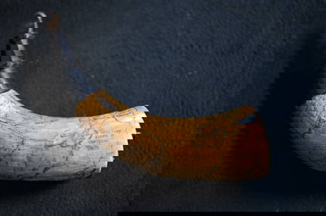
Sold2022Very rare "hot air balloon" engraved powder horn.Very rare "hot air balloon" engraved powder horn. Belonged to John Howard and believed to be from Brookfield, Maine. This is possibly the only powder horn to depict a image of a hot air balloon. ExactSee Sold Price
Sold2024American Engraved Powder Horn, Boston SiegeInscribed "J. Webb / 10 / Mass Rg 1775" (identified with John Webb,1758-1843, from Weymouth, Mass., enlisted in 1776 in the 3rd Regt. (created in 1775) and in service when it was folded into the 10th,See Sold Price
Sold2024American Engraved Powder Horn, N. Carolina, 1814Inscribed "D: St.: JOHN" (identified with David St. John, 1790-1873, of Norwalk, Ct.) further labeled "1813, 1814," "FORT HAMPTON," (a small battery on the Outer Banks of North Carolina) and "SLOOP INSee Sold Price
Sold2024American Engraved Powder Horn, Philadelphia, 1775Inscribed "JOHANN / REGS ESQR. / II PA Rgt. / 1775" (identified with John Rex, 1741-1802, resident of Germantown) further engraved with a view of Philadelphia as seen from the river, with a ship and wSee Sold Price
Sold2024American Engraved Powder Horn, Ft. Niagara, c.1760Inscribed "JOHN SMITH 17" (unidentified) densely engraved with a British-flagged man of war; the plan of a fort (believed by Guthman to be Fort Niagara); stylized fish and nets; a woman in a dress; atSee Sold Price
Sold2024American Engraved Powder Horn, J. Loose, Pa.Inscribed "July 25th, 1829 / Ja. Loose" (identified with Jacob Loose, 1743-1830, a German immigrant who served as a Private in John Patton's Battalion, formed in August, 1776) also with small engravedSee Sold Price
Sold2021John Ogilby, circa 1698, The Road from London to St.John Ogilby, circa 1698, The Road from London to St. Davids in com. Pembroke, circa 1698, hand coloured engraved strip road map, sheet 14, 12" x 17.5", unframed.See Sold Price
Sold2024Engraved American Powder Horn11 inches long, lots of engraving to include, 1854, Dunham King, Granville Ohio, also the name John I Thomas. Sun, moon, ,houses, birds, wood cap and plugSee Sold Price
Sold20151810 Powder Horn and 1818 Document(1) William Chamberlain powder horn engraved W.C. 1810 within shield and (1) 1818 framed committee to assess damages involving Capt. George Yates, signed Wm. McClintock, John Curton and Simon Elliot.See Sold Price
Sold2022After John OgilbyAfter John Ogilby After John Ogilby, 17th/18th century, 'The Continuation of the Road from London to Barwick', engraved and hand coloured road map, framed, 33 x 45.5cm Condition Report: Some visible cSee Sold Price
Sold2019Senex & Ogilby 1719 Road Map. London to Montgomery"The Road from London to Montgomery in North Wales" Copper Engraved Map Published 1719, London for "An Actual Survey of all the Principal Roads of England and Wales" by John Ogilby and John Senex. PapSee Sold Price
Sold2020Senex & Ogilby 1719 Road Map. London to Montgomery"The Road from London to Montgomery in North Wales" Copper Engraved Map Published 1719, London for "An Actual Survey of all the Principal Roads of England and Wales" by John Ogilby and John Senex. PapSee Sold Price
Sold2018WALKER, John and Charles.WALKER, John and Charles. Hobson's Fox-Hunting Atlas. London: J. and C. Walker, [ca 1868-1871]. Folio (368 x 242 mm). 42 engraved or lithographic double-page maps hand-colored in outline, hunts stampeSee Sold Price
Sold2018Captain McClintock THE VOYAGE OF THE FOX IN THE ARCTICCaptain McClintock THE VOYAGE OF THE FOX IN THE ARCTIC SEAS A NARRATIVE OF THE DISCOVERY OF THE FATE OF SIR JOHN FRANKLIN AND HIS COMPANIONS 1860 Double-Sided Folding Map Engraved Francis McClintock ISee Sold Price
Sold2022Britain.- Cary (John) Cary's New Itinerary..., first edition, 1798 & others, British topography (7)NO RESERVE Britain.- Cary (John) Cary's New Itinerary; or, an Accurate Delineation of the Great Roads..., first edition, engraved title and dedication, folding engraved map (water-stained, torn and reSee Sold Price
Sold2022Britain.- Cary (John) Cary's Traveller's Companion or a Delineation of the Turnpike Roads of EnglandBritain.- Cary (John) Cary's Traveller's Companion or a Delineation of the Turnpike Roads of England and Wales, engraved throughout, title, advertisement and contents ff., 43 maps, hand-coloured in ouSee Sold Price
Sold2019OGILBY, John (1600-1676). The Road from CambridgOGILBY, John (1600-1676). The Road from Cambridg to Coventry. [London, ca 1570s]. Engraved scroll map hand-colored in wash and outline, visible area 17 1/4 x 14 1/14 in. (444 x 360 mm). DecoSee Sold Price
Sold2024JOHN SPEED ENGRAVED MAP "THE KINGDOME OF SCOTLAND" Britain, 17th Century 15" x 19.5" sight. FramedJOHN SPEED ENGRAVED MAP "THE KINGDOME OF SCOTLAND"Britain, 17th CenturyShows an inset of the "Yles of Orknay", and eight vignettes of Scottish commoners arranged in two panels.Titled in cartouche. DouSee Sold Price
Sold2023Rare 1721 John Senex "A New Map Of The World"DESCRIPTION: Rare antique engraved map by John Senex entitled "A New Map of the World" depicting California as an island and with parts of the world still unmapped. Further featuring hand coloring, foSee Sold Price
Sold2024American Engraved Powder Horn, Pennsylvania MapLate 18th century; engraved with with a schematic map of Pennsylvania, labeling some major towns and forts (possibly executed in the 19th century, but most likely after the Federal period); cow horn wSee Sold Price
Sold2016The Kingdom of ChinaJohn Speed (1552-1629). Copperplate Engraved Map. Abraham Goos & John Speed: 1627. 17 1/4 x 21 1/2 inches. This superb map of China, Korea and Japan is the only carte-a-figures map made of the region.See Sold Price
Sold2023Powder Horn with a very detailed map engraved of Northern Illinois and Eastern Iowa. Also hasPowder Horn with a very detailed map engraved of Northern Illinois and Eastern Iowa. Also has Harold Smith engraved in it.See Sold Price
May 05Tremont AuctionsJohn Speed and Francis Lamb "Map of New England and New York", ca. 1676. Hand colored engraved map$600(2 bids)
355 Lots AwayJasper52Ireland by John Thomson. Coach roads 1817 old antique vintage map plan chart$260
437 Lots AwayJasper52PALESTINE. Jaffa/Tel Aviv Nazareth views.Jordan Lebanon.TALLIS/RAPKIN 1851 map$260
433 Lots AwayJasper52SCOTLAND Edinburgh, Holyrood & Shinty views. Counties. TALLIS & RAPKIN 1851 map$360
BonhamsZATTA, ANTONIO. 1757-1797. La Pensilvania, la Nuova York, il Jersey settentrio[na]le.... Venice:...$120(9 bids)
May 15Doyle New YorkTwo Scottish Silver Plate Mounted Ram's Horn Table Mulls and a Brass Mounted Lighter 19th/20th$300
6 days LeftFreeman's | HindmanA group of three Federal silver punch ladles, William Garret Forbes (1751-1840), New York, NY, Isaac$750
297 Lots AwayJasper52The United Parishes of St. Giles in the Fields & St. George, Bloomsbury 1828 map$550
380 Lots AwayJasper52Cary's reduction of his large map of England & Wales'. Turnpikes canals &c 1834$360
2 days LeftLeland LittleThucydides's History of the Peloponnesian War in Greek and Latin, with Folding Maps$200(3 bids)
May 09Hunt and Peck Estate Services, Inc.Lot of 7 1st Edition books by John Dos Passos One Signed$200
7 days LeftDoyle New YorkThe Hogan copy of the first edition, first issue of Uncle Tom’s Cabin$5,000


![WALKER, John and Charles.: WALKER, John and Charles. Hobson's Fox-Hunting Atlas. London: J. and C. Walker, [ca 1868-1871]. Folio (368 x 242 mm). 42 engraved or lithographic double-page maps hand-colored in outline, hunts stampe](https://p1.liveauctioneers.com/197/119933/61100797_1_x.jpg?height=310&quality=70&version=1522758048)


![OGILBY, John (1600-1676). The Road from Cambridg: OGILBY, John (1600-1676). The Road from Cambridg to Coventry. [London, ca 1570s]. Engraved scroll map hand-colored in wash and outline, visible area 17 1/4 x 14 1/14 in. (444 x 360 mm). Deco](https://p1.liveauctioneers.com/197/151909/76680351_1_x.jpg?height=310&quality=70&version=1570472488)


![ZATTA, ANTONIO. 1757-1797. La Pensilvania, la Nuova York, il Jersey settentrio[na]le.... Venice:... (1 of 3)](https://p1.liveauctioneers.com/1043/324005/175444948_1_x.jpg?height=282&quality=70&version=1713980374)


