Sold2021North PacificTitle: North Pacific Publication Date: 1868 Cartographer: IMRAY, JAMES F. Publisher: JAMES IMRAY & SON Description: Comprehensive large sea chart of Japanese and Alaskan waters with copious soundingsSee Sold Price
Sold2023Pacific Ocean sea chart. Ports lighthouses mail routes dockyards LARGE 1916 mapThe Pacific Ocean' by George Philip & Son Ltd (1916). Antique colour maritime map chart; Scale 1:40,000,000, 49.0 x 69.0cm, 19.25 x 27.25 inches; Please note that this is a folding map. Description: TSee Sold Price
Sold2023Large chart of Pacific & Indian Oceans 1813Heading: Author: Espinosa y Tello, Josef Title: Carta general para las navegaciones a la India Oriental por el Mar del Sur y el Grande Oceano que separa el Asia de la America Place Published: LondonSee Sold Price
Sold2021Large Scale Union Pacific McKeen Motor Coach CarThis is a great reproduction piece of a Union Pacific McKeen Motor Coach that is incomplete, but it appears that the hardest part has been done, now it just needs to be completed with your own personaSee Sold Price
Sold2022Canada.- Jefferys (Thomas) An Exact Chart of the RiverCanada.- Jefferys (Thomas) An Exact Chart of the River St. Laurence, from Fort Frontenac to the Island of Anticosti Shewing the Soundings, Rocks, Shoals &c..., large-scale navigational chart of the StSee Sold Price
Sold2018Canada.- Jefferys (Thomas) An Exact Chart of the RiverCanada.- Jefferys (Thomas) An Exact Chart of the River St. Laurence, from Fort Frontenac to the Island of Anticosti Shewing the Soundings, Rocks, Shoals &c..., large-scale navigational chart of the StSee Sold Price
Sold2018Benard: Magellan Strait with Coastal ProfilesA large-scale dramatic chart of the Magellan Strait with extensive coastal detail and four coastal profiles, based on the observations and discoveries of Captains Byron, Wallis, and Carteret.; G642; BSee Sold Price
Sold2019Bruce North, large scale paintingBruce North, large scale painting, Bruce North (American, b. 1940), "The Swamp", 1981, oil on canvas, signed "B. North" and dated at lower right, gallery label verso, 47.5"h x 68"w (sight), 57"h x 78"See Sold Price
Sold2022Pacific Large Scale Wooden KnightsMeasuring 7.25" to 14" tall. Mounted Knight missing sword, otherwise both in excellent condition. Unboxed. **Additional Shipping Due to Large Lot Size**See Sold Price
Sold2018Bellin: Large Hispaniola MapThe first edition of Bellin's spectacular, large scale map of Hispaniola. Its meticulous topographical and nautical detail makes this one of the major 18th century maps of Hispaniola.; RS2608; Bellin;See Sold Price
Sold2024Rare Antique Map - Hudson Bay Chart - Old Map of North America - Bellin - Jacques"Carte de la Baye de Hudson". Its finely engraved, hand-coloring engraved map from the Dutch edition of acques Nicolas Bellin Histoire "General of Travel". Published in Amsterdam. A handsome chart ofSee Sold Price
Sold2019Australia.- Dept. of the Interior, Canberra (Property &Australia.- Dept. of the Interior, Canberra (Property & Survey Branch) Australia, large-scale wall map with inset chart of Tasmania, lithograph printed in colours on wove paper, 760 x 1005 mm. (30 x 4See Sold Price
Sold2022(MEXICO.) Robert Dudley. Carta Particolare della Parte Ocidentale della Nuova Spagnia, e del la(MEXICO.) Robert Dudley. Carta Particolare della Parte Ocidentale della Nuova Spagnia, e del la California. Large double-page engraved chart of the Pacific coast of Mexico and the southern tip of theSee Sold Price
Sold2018Bellin: Chart of the North Seas/Greenland/ScandinaviaTitle/Content of Map: Carte Reduite des Mers du Nord Cartographer: Bellin Place & Date: Paris / 1758 Size: 18" x 13" Condition: b&w; overall age toning; old folds and wrinkling; one small hole (on NorSee Sold Price
Sold2021AGRA, NORTH INDIA ORIENTAL CARPET, ANTIQUE W 14' 1", LAGRA, NORTH INDIA ORIENTAL CARPET, ANTIQUE W 14' 1", L 16' 10" Blue ground. Hand knotted with large-scale botanical and cypress tree motifs in an allover closed field. From a Bloomfield Hills home.See Sold Price
Sold2021Large 18th C. Hawaiian Wood & Sennit Fishing HookNorth Pacific, Hawaiian Islands, ca. 18th century CE. A gorgeous wooden fishing hook used for shark or other larger fish with a curved profile and barb on the tip. At the top is a length of sennit (coSee Sold Price
Sold2021Large Hawaiian Pre-Contact Basalt Adze BladeNorth Pacific, Hawaiian Islands, Pre-Contact Period, ca. 14th to 18th century CE. A sizable and hefty adze (adz) blade of an elongated trapezoidal form made to be used for cutting, carving, and smoothSee Sold Price
Sold2021Large 17th C. Hawaiian Basalt PestleNorth Pacific, Hawaii, ca. 17th century CE. A splendid and sizeable volcanic stone pestle displaying a thick, round pounding head and a lengthy body that tapers to a petite, hemispherical handle. HandSee Sold Price
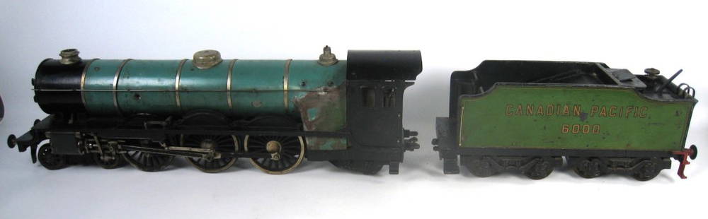
Sold2024Canadian Pacific 6000 Green Locomotive & Tender Live Steam Gigantic Large Scale EnglishImmense brass steam locomotive, likely British and similar in make to Stevens Dockyard toys. Model toy is a Pacific style with untested livesteam. Gauge is close to 2 inches in width between flanges.See Sold Price
Sold2018Iceland.- Bellin (Jacques Nicolas) Carte Reduite deIceland.- Bellin (Jacques Nicolas) Carte Reduite de l'Islande et des Mers qui en sont Voisines ..., large chart of Iceland with the Faroe Islands in the lower right corner, extensive title and descripSee Sold Price
Sold2018Jefferys / Sayer: Pacific Coasts Nicaragua / Costa RicaPart of the Provinces of Costa Rica and Nicaragua with the Lagunas. A magnificent, large-scale map of a small slice of the Pacific coasts of Nicaragua and Cost Rica, from San Miguel (now in El SalvadoSee Sold Price
Sold2018Antique Chart of the Island of Tahiti, 1775Title/Content of Map: Chart of the Island of Otaheite Date Printed: 1775 ca. Cartographer: Capt. James Cook R.N. Size (inches): 12.3x16.1 Large scale map of the Island of Tahiti, with detailed typograSee Sold Price
Sold2017Dépôt de la Marine: Chart of Martinique Harbors, 1828Map: Plan des Havres du Robert et du Francois (Ile de la Martinique) Cartographer: Depot-General de la Marine Place & Date: Paris / 1828 Size: 35 1/2" x 24 1/2" A large-scale French Hydrographic OfficSee Sold Price
Sold2022Large Scale Contemporary Modern White Metal BenchLarge Scale Contemporary Modern White Metal Bench. Measures 19 x 84.5 x 17 inches. Property of a designer decorated North Salem, New York equestrian estate.See Sold Price
5 days LeftJasper52Hawaiian or Sandwich Islands North Pacific Ocean ADMIRALTY chart 1881 (1955) map$360
Featured5 days LeftJasper52The Seacoasts of Ireland from Dublin to London-Derry. MOUNT & PAGE 1758 map$280
5 days LeftJasper52City of York #9 Minster & Medieval centre. Aldwark Monkgate Hungate. OS 1852 map$1,200
5 days LeftJasper52Bermuda Islands, North Atlantic Ocean. ADMIRALTY sea chart 1946 (1950) old map$360
Legacy Auction & RealtySNJ-5 North American T-6 Texan Aircraft, WWII Mahogany Desktop Model Airplane w/Stand$10(1 bid)
5 days LeftJasper52NW Coast of America & NE Coast of Asia… ROBERTS / DELAROCHETTE. Pacific 1794 map$700
5 days LeftJasper52Chart of the Sea Coasts Biscay & Gallicia [Galicia]. Spain MOUNT & PAGE 1758 map$360
5 days LeftJasper52Océanique Partie de la Nle Zélande 59 New Zealand North Is VANDERMAELEN 1827 map$260


![Chart of the Sea Coasts Biscay & Gallicia [Galicia]. Spain MOUNT & PAGE 1758 map (1 of 1)](https://p1.liveauctioneers.com/5584/326140/175577208_1_x.jpg?height=282&quality=70&version=1713288521)


![The Sea Coast of France from Ushent to Olone [Olonne]. MOUNT & PAGE 1758 map (1 of 1)](https://p1.liveauctioneers.com/5584/326140/175576897_1_x.jpg?height=282&quality=70&version=1713288521)


