Sold2017Colton: Antique Pre Civil War Map South Carolina, 1861Title/Content of Map: Pre Civil War South Carolina by Colton Date Printed: 1861 Cartographer: J.H. Colton Material/Medium: Paper Size: 17 1/2" x 14" Hand colored steel engraved Map from 'Colton's GeneSee Sold Price
Sold2018Pre Civil War South Carolina Map Charleston 1847Original hand colored map in overall good condition. Not a repro or restrike. Recently matted and framed using conservation materials. Framed dimensions 23 x 19 inches.See Sold Price
Sold20201894 Cowles Civil War Map of South Carolina and PartsTitle/Content of Map: 1894 Cowles Civil War Map of South Carolina and Parts of North Carolina -- General Topographical Map, Sheet IV [Plate CXXXIX] Date: 1894, Washington Cartographer: C Cowles (compiSee Sold Price
Sold20241864 Map of Virginiaprinted at the Coast Survey Office. A.D. Bache Supdt. Civil War era railroad map. Framed and under glass. Overall size is 27" x 41" Map has some creases from being folded and stains.See Sold Price
Sold20231893 Civil War Map of the South -- Section of G. Woolworth Colton's New Guide Map of the UnitedTitle: 1893 Civil War Map of the South -- Section of G. Woolworth Colton's New Guide Map of the United States and Canada with Railorads, Counties, etc. 1863. Used by General Grant in Marking the PropoSee Sold Price
Sold2021Civil War Geographical Boundary mapDefinitive map of the geographical boundaries between the Union and Confederate armies. Opens a window into the state of the U. S. during the height of the Civil War. “Map of the United States oSee Sold Price
Sold2017Johnson’s Civil War era map of North & South CarolinaHistoric map shows the Carolinas in great detail shortly following the outbreak of the Civil War. States hand-colored at the time of publishing with color coding according to county. Inset map depictsSee Sold Price
Sold20221864 Civil War American Commerce Reports HUGE MAP Railroads Trade Import1864 Civil War American Commerce Reports HUGE MAP Railroads Trade Import Statistics of the Foreign and Domestic Commerce of the United States is a mid-19th-century report on the values of goods and trSee Sold Price
Sold20221864 Civil War era American Commerce Reports Trade Import HUGE MAP Railroads1864 Civil War era American Commerce Reports Trade Import HUGE MAP Railroads Statistics of the Foreign and Domestic Commerce of the United States is a mid-19th-century report on the values of goods anSee Sold Price
Sold20191862 1ed War with South CIVIL WAR Military Tomes1862 1ed War with South CIVIL WAR Military Tomes Illustrated Gettysburg MAPS The American Civil War played an important role in the expansion and growth of book publication in the United States, as peSee Sold Price
Sold20191892 Cowles Civil War Map of Battles of the Army of theTitle/Content of Map: 1892 Cowles Civil War Map of Battles of the Army of the Cumberland in Kentucky, Virginia and Points South -- Map Prepared to Exhibit the Campaigns in which the Army of the CumberSee Sold Price
Sold201812 Books on South & Civil War Incl. Carolina, Sou12 Books on South & Civil War Incl. Carolina, South Carolina in early maps-- Dimensions: ---See Sold Price
Sold2022Vintage RR map of Maryland & Delaware, 1850Excellent 1850 map of Maryland and Delaware with a chart of Chesapeake Bay Steamboat Routes. Published a decade before the Civil War and during an explosion in the country's railroad routes, the map aSee Sold Price
Sold20214 Pcs Obsolete Currency Notes$3 January 1863 Bank of Chattanooga Confederate note, 50 units North Missouri Railroad note with map on back, $5 Indiana State Mining & Manufacturing Company Shinplaster note - this note was issued bySee Sold Price
Sold2023Civil War era 1863 map of Mexico & Caribbean nationsLovely and vintage double-page map showing all of Mexico, Central America, Texas, Indian Territory and states of the Deep South during the middle of the American Civil War. Map has an 1860 copyright bSee Sold Price
Sold2019Two Copies of Civil War Atlas, "General TopographicTwo Copies of Civil War Atlas, "General Topographic Map, South La., Miss.," Plate 156, H. - 18 1/2 in., W. - 30 in. (2 Pcs.)See Sold Price
Sold2018Meyer: Tennessee, 1849/ Nashville & Knoxville InsetsThe beautifully detailed and colored map of pre-Civil War Tennessee, from Meyer's Auswanderungs-Atlas (Emigrant's Atlas) of North America. Includes a key to canals, railroads, and main roads; steamshiSee Sold Price
Sold2020Grant's Sec Asks for Map of Proposed Railroad ExtensionGrant Ulysses Grant’s Sec Asks for Map of Proposed Railroad Extension in Kansas, Ex-Forbes [ULYSSES S. GRANT.] Homer Porter, Manuscript Letter Signed, to Columbus Delano, November 2, 1871, WashingtoSee Sold Price
Sold2016Large 1862 US Civil War Wall MapColton's Map of the Southern States. Including Maryland, Delaware, Virginia, Kentucky, Tennessee, Missouri, North Carolina, South Carolina, Georgia, Alabama, Mississippi, Arkansas, Louisiana, Texas ..See Sold Price
Sold2023Civil War era map of N. America with unsettled state bordersOne of the key maps in the 1860s Johnson series of North America. In this map Dakota Territory has yet to split into its north and south divisions while it stretches to encompass what will eventuallySee Sold Price
Sold2021Civil War era map of deep southern states, 1860/62Title: Civil War era map of deep southern states, 1860/62 Description: "Authentic vintage map of three deep south states whose partial borders are defined by the mighty Mississippi River, one of the gSee Sold Price
Sold20201860 Life of John Quitman American Mexican War South1860 Life of John Quitman American Mexican War South Slavery Illustrated MAP A rare pre-Civil War printing of Claiborne’s “Life and Correspondence of John A. Quitman.” This book is a telling ofSee Sold Price
Sold2023Civil War era map of Florida, 1863Lovely early map of Florida, vividly hand colored by county, with a large inset of the Florida Keys. Shows towns, railroads, villages, post offices, forts, etc. Only five counties shown in the southerSee Sold Price
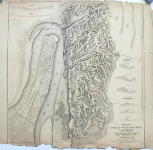
Sold2017Map of the Siege of Vicksburg, MississippiMap: Map of the Siege of Vicksburg, Mississippi Description: This large battle map identifies Union and Confederate entrenchments. It is very detailed, showing the roads, streets, houses, railroads, vSee Sold Price
May 09Weatherham Estate TreasuresAbraham Lincoln Bronze Bust Sculpture On Marble Base - Signed Original - 10lbs$400
May 14Fleischer's Auctions[LINCOLN] 1864 California National Union Ticket "Rally Round the Boys!"$225(2 bids)
May 14Fleischer's AuctionsLincoln's Funeral Cortège Book by Custodian of Lincoln's Tomb$150(2 bids)
4 days LeftMatthew Bullock AuctioneersAlbert Taylor Bledsoe, Confederate Colonel, Acting Assistant Secretary of War,Confederate States of$70
4 days LeftMatthew Bullock AuctioneersGeorge Washington Baird, Rear Admiral, U.S. Navy, USS Mississippi, USS Albatross, acquaintance of$70
May 15Fleischer's Auctions[Gettysburg] Sword & Journal of Confederate Officer (41st Virginia)$1,700(7 bids)


![1894 Cowles Civil War Map of South Carolina and Parts: Title/Content of Map: 1894 Cowles Civil War Map of South Carolina and Parts of North Carolina -- General Topographical Map, Sheet IV [Plate CXXXIX] Date: 1894, Washington Cartographer: C Cowles (compi](https://p1.liveauctioneers.com/5584/162222/81927562_1_x.jpg?height=310&quality=70&version=1582719732)


![Grant's Sec Asks for Map of Proposed Railroad Extension: Grant Ulysses Grant’s Sec Asks for Map of Proposed Railroad Extension in Kansas, Ex-Forbes [ULYSSES S. GRANT.] Homer Porter, Manuscript Letter Signed, to Columbus Delano, November 2, 1871, Washingto](https://p1.liveauctioneers.com/6306/166544/84056656_1_x.jpg?height=310&quality=70&version=1587156278)


![[LINCOLN] 1864 California National Union Ticket "Rally Round the Boys!" (1 of 1)](https://p1.liveauctioneers.com/7226/322253/173251604_1_x.jpg?height=282&quality=70&version=1710004847)

![[RE LEE] Signed Photograph & Letter To Namesake (1 of 3)](https://p1.liveauctioneers.com/7226/325455/175169169_1_x.jpg?height=282&quality=70&version=1712370394)


![[Confederate] Sword & Effects of North Carolina Officer (1 of 16)](https://p1.liveauctioneers.com/7226/325455/175169159_1_x.jpg?height=282&quality=70&version=1712370394)
![[Gettysburg] Sword & Journal of Confederate Officer (41st Virginia) (1 of 11)](https://p1.liveauctioneers.com/7226/325455/175169156_1_x.jpg?height=282&quality=70&version=1712370394)
