Sold2022(CIVIL WAR.) Jean-Rodolphe Mayer. Nouvelle Carte des Etats-Unis de l'Amerique du Nord… 2de(CIVIL WAR.) Jean-Rodolphe Mayer. Nouvelle Carte des Etats-Unis de l'Amerique du Nord… 2de Edition. Large hand-colored lithographed map of the United States with a keyed reference table numberinSee Sold Price
Sold2022[CONSTITUTION] DE LA ROCHEFOUCAULD D'ENVILLE, LOUIS ALEXANDRE (Duc de), translator. Constitutions[CONSTITUTION] DE LA ROCHEFOUCAULD D'ENVILLE, LOUIS ALEXANDRE (Duc de), translator. Constitutions des Treize Etats-Unis de L'Amerique. Philadelphia and Paris: [printed for La Rochefoucault and BenjamiSee Sold Price
Sold2024BEN. FRANKLIN CONSTITUTIONS DES TRIEIZE ETATS 1783Constitutions Des Treize Etats-Unis de l'Amerique. Printed 1783 by D. Pierres, Paris. Contains the first printed appearance of the Great Seal of the United States designed by Benjamin Franklin. The FrSee Sold Price
Sold2018Map, United States, 1784, first map of the nationMap, United States, 1784,"Carte Des Etats-Unis De L'Amerique Suivant le Traite de Paix de 1783. Dediee et Presentee A.S. Excellence M. Benjamin Franklin Ministre Pleinipotentaire des Etats-Unis", theSee Sold Price
Sold2021Antique French Map of United States- Etats-Unis De L'Amerique Septentrionale Avec Les Isles Royale, De Terre Neuve, De St. Jean, L'Acadie &c.; Hand-colored; Ches Boudet Imprimeur du Roi; Paris; undated (circa 1785). One of the early maSee Sold Price
Sold2016L'Amerique Septentrionale, F. Delamarche 1785Title: Etats-Unis De L'Amerique Septentrionale Avec Les Isles Royale, De Terre Neuve, De St. Jean, L'Acadie Subject: United States/American Revolution Maker: F. Delamarche Date: 1785, Paris Size: 18.7See Sold Price
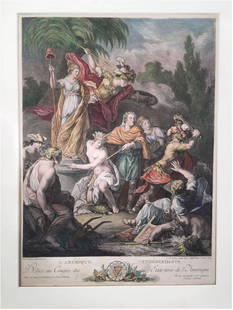
Sold2023Antoine BOREL: Color Engraving by Le VasseurExtremely rare, original 1778 engraving titled "L'Amerique Independante; Dediee au Congres des Etats Unis de l'Amerique" [Independent America; dedicated to the Congress of the United States of AmericaSee Sold Price
Sold2018Buchon: Antique Map of USA territorial developmentTITLE/CONTENT OF MAP: 'Carte de l'adjonction progressive des divers états au territoire et à l'union constitutionelle des États-Unis de l'Amérique du Nord 1825' This fascinating map shows the terrSee Sold Price
Sold2022c. 1788 French Map of the Eastern United StatesHistoric Maps c. 1788 Map, "Les Etats Unis de L'Amerique Septentrionale, Partie Orientale" (Eastern Part of the Northern United States of America) by M. (Rigobert) Bonne c. 1788 Map titled, "Les EtatsSee Sold Price
Sold202118TH CENTURY FRENCH MAP OF SOUTHEASTERN USRigobert Bonne (French, 1727-1794). "Carte De la Partie Sud Des Etats Unis De L'Amerique Septentrionale" -circa 1780, engraving. Provenance: From the Lifetime Collection of Billy S. Arant, Jr., ChattaSee Sold Price
Sold20211800 Weld Map of Northern United States and Great LakesTitle: 1800 Weld Map of Northern United States and Great Lakes -- Partie des Etats-Unis de L'Amerique Septentrionale Cartographer: I Weld Year / Place: 1800, Paris Map Dimension (in.): 16.1 X !8.2 in.See Sold Price
Sold2023"Carte De La Partie Nord, Des Etats Unis, de L'Amérique Septentrionale" by Rigobert Bonne. Paris,“Carte De La Partie Nord, Des Etats Unis, de l'Amerique Septentrionale” by Rigobert Bonne, Ca. 1780s. This post-revolutionary war map features a detailed overview of the mid-Atlantic regioSee Sold Price
Sold2019Two Maps by Rigobert Bonne (1727-1794, Paris), Isles deTwo Maps by Rigobert Bonne (1727-1794, Paris), Isles de Cuba et de Jamaiqe, 1750; together with Les Etats Unis de L'Amerique Septentrionale les Royale de Terre Neuve, de St. Jean et L'Acadie; et partiSee Sold Price
Sold2017E.F. Delamarche, French Framed Map"Etats-Unis de L'Amerique." Approx. 18" x 23" sight, 22 1/2" x 28 1/2" framed. (6215) Yellowing. Damage to glass.See Sold Price
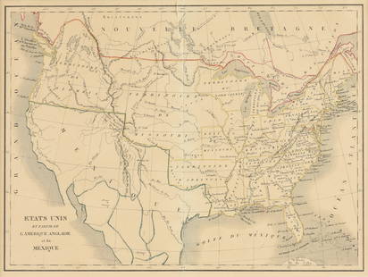
Sold2023EUSTACHE-HYACINTHE LANGLOIS (1777-1837) A MEXICAN TEXAS MAP, "Etats Unis et Partie de L'AméEUSTACHE-HYACINTHE LANGLOIS (1777-1837) A MEXICAN TEXAS MAP, "Etats Unis et Partie de L'Amérique Anglaise et du Mexique," PARIS, CIRCA 1830, lithograph on cream wove paper with hand color, probabSee Sold Price
Sold2023Carte des Etats-Unis du Mexique & Guatemala. Mexico USA Southwest LAPIE 1829 mapCAPTION PRINTED BELOW PICTURE: Carte des Etats-Unis du Mexique // Carte du Guatemala, ou Provinces-Unies de l'Amérique centrale [The United States of Mexico // Guatemala, or the United ProvincesSee Sold Price
Sold2017Bonne: Antique Map of Northeastern Canada, 1783Map: Partie de l'Amerique Septentrionale qui comprend le Canada, la Louisiane, le Labrador, le Grenland, les Etats Unis, et la Floride Cartographer: Bonne Place & Date: Paris / 1783 Size: 17" x 11 5/8See Sold Price
Sold2016Map of Canada Framed Vintage 40s Print After 1720Map of Canada Framed Vintage 40-s Print After 1720 Guillaume De L'Isle Carte Du Canada Qui Comprend la Partie Septentrionale Des Etats Unis D'Amerique Canada and Great Lakes Map Approximately 21 5/8"See Sold Price
Sold2016Waterfall near the baths of Schooley. North America.Print of steel engraving titled „Chute d‘eau pres les bains de Schooley“.Drawn by Milbert.Engraved by L. Thienon.From „Etats-Unis D‘Amerique by M. Roux de Rochelle. Published by Firmin didotSee Sold Price
Sold2016Landscape. United States. North America. 1839.Print of steel engraving titled „Palissades naturelles de l‘Hudson“.Drawn by Milbert.Engraved by unknown.From „Etats-Unis D‘Amerique by M. Roux de Rochelle. Published by Firmin didot freres.See Sold Price
Sold2016Bridge over the Hudson River near Lucerne. 1839.Print of steel engraving titled „Pont sur l‘Hudson pres Luzerne“.Drawn by Milbert.Engraved by Chavannes.From „Etats-Unis D‘Amerique by M. Roux de Rochelle. Published by Firmin didot freres.See Sold Price
Sold2022Chevillet. Wasington, Generalissime des Etats.[Engraving] Chevillet, Justus [after Peale, Charles Willson]. Wasington, Generalissime des Etats de l'Amerique. Paris, c.1785. Full bust, to left, in uniform. Tree and landscape in background. Oval, wSee Sold Price
Sold2019Les Etats Unis de I'Amérique Septentrionale, partieTITLE/CONTENT OF MAP: 'Les Etats Unis de I'Amérique Septentrionale, partie Occidentale [The United States of North America, western part]' The top image on the right hand side shows the entire map. TSee Sold Price
Sold2021Lapie - Carte de Etats Unis d’Amérique du Canada, duArtist: Lapie Title: Carte de Etats Unis d’Amérique du Canada, du Nouveau Brunswick et d’une partie de la Nouvelle Bretagne Description: Lapie - Carte de Etats Unis d’Amérique du Canada, du NoSee Sold Price
7 days LeftLeland LittleA Glowing French Assessment of American Law During the American Revolution$50(1 bid)
Apr 27Jeschke Jadi Auctions Berlin GmbHDuplessis-Bertaux, nach Jean Indépendance des États-Unis. Handkolorierter Kupferstich von€1,200
May 14Fleischer's Auctions1755 Map Partie de l'Amerique Septentrionale, qui comprend Le Cours de L'Ohio...$300(3 bids)
May 16Potter & Potter AuctionsLa Reponse de L’Amerique aux Boches. Paris: Louchet Publici...$400
May 01Adam's AuctioneersMICHAUX, François André [1770-1855] OAKS of the United States and of Canada Philadelphia€500
BonhamsCHASTELLUX, FRANÇOIS JEAN, MARQUIS DE. 1734-1788. Voyages de M. le Marquis de Chastellux da...$10(1 bid)
Apr 27Jeschke Jadi Auctions Berlin GmbHA. u. Alcide d'Orbigny, Valenciennes Voyage dans l'Amérique méridionale (Le Bresil, la€750
Apr 27Jeschke Jadi Auctions Berlin GmbHSammlung von 11 alten Deutschlandkarten. Überwiegend 17. u. 18. Jh. Je (grenz-)kolorierter€300
4 days LeftChristie'sTABATIÈRE ÉCOSSAISE D'ÉPOQUE GEORGE IV EN CORNE DE BÉLIER MONTÉE EN OR DEPreview Only
Apr 27Jeschke Jadi Auctions Berlin GmbHSammlung von 7 gestoch. u. tls. kol. Karten. Verso tls. mit typogr. Text. 1 Karte in Punkten unter€400


![[CONSTITUTION] DE LA ROCHEFOUCAULD D'ENVILLE, LOUIS ALEXANDRE (Duc de), translator. Constitutions: [CONSTITUTION] DE LA ROCHEFOUCAULD D'ENVILLE, LOUIS ALEXANDRE (Duc de), translator. Constitutions des Treize Etats-Unis de L'Amerique. Philadelphia and Paris: [printed for La Rochefoucault and Benjami](https://p1.liveauctioneers.com/292/250642/130213472_1_x.jpg?height=310&quality=70&version=1654271664)


![Chevillet. Wasington, Generalissime des Etats.: [Engraving] Chevillet, Justus [after Peale, Charles Willson]. Wasington, Generalissime des Etats de l'Amerique. Paris, c.1785. Full bust, to left, in uniform. Tree and landscape in background. Oval, w](https://p1.liveauctioneers.com/179/268856/140615791_1_x.jpg?height=310&quality=70&version=1668545725)
![Les Etats Unis de I'Amérique Septentrionale, partie: TITLE/CONTENT OF MAP: 'Les Etats Unis de I'Amérique Septentrionale, partie Occidentale [The United States of North America, western part]' The top image on the right hand side shows the entire map. T](https://p1.liveauctioneers.com/5584/147595/74587359_1_x.jpg?height=310&quality=70&version=1565730371)


![MICHAUX, François André [1770-1855] OAKS of the United States and of Canada Philadelphia (1 of 3)](https://p1.liveauctioneers.com/533/325941/175488532_1_x.jpg?height=282&quality=70&version=1712845571)


