Sold2018Early Map Egypt Nubia AfricaDe l'Egipte. Antique map by Clouet, Paris, 1730. Egypt, Nubia, Abyssinia, Middle East, Asia. . 16" x 24.See Sold Price
Sold2019Blackie & Weller 1882 Lot of 5 Maps of AfricaIncl "Africa" Continent "Marocco Algeria and Tunis" Egypt/Nubia/Abyssinia "Western Africa" and "South Africa" Lithograph Maps Published 1882 by Blackie & Son, London for "The Comprehensive Atlas & GeoSee Sold Price
Sold20171833 Nubia & Abyssinia EGYPT Ethiopia Africa Missions1833 Nubia & Abyssinia EGYPT Ethiopia Africa Missions Geography MAP Bishop Michael Russell was a 19th-century historian who was well-versed in a variety of subjects, including Biblical and Holy Land hSee Sold Price
Sold2023Box of 35+ Assorted 19th/20th C. Small MapsBox of mostly 19th and early 20th century small maps, approximately 35 pieces including maps of Paris, London, Spain, Caudine Forks, New England, Egypt, Russia, Italy, Europe, Africa, Asia, road maps,See Sold Price
Sold20181714 Moll Map of North Africa -- The East Part ofTitle/Content of Map: 1714 Moll Map of North Africa -- The East Part of Barbary Containing Tunis, Tripoli. Barca, Egypt, Nubia, Part of Biledul… Date: 1714 c., London Cartographer: H Moll Size: 6.9See Sold Price
Sold2021Egypt, Nubia, Abyssinia 1891Title/Content of Map: Egypt, Nubia, Abyssinia 1891 Date Printed: 1891Material/Medium: Paper Size: approx. 11x14.5 inches John w. Illif & Co., Chicago Reserve: $30.00 Shipping: Domestic: Flat-rate ofSee Sold Price
Sold2022EARLY MAP OF AFRICA"Africae" "Newly Done into English John Speede / G. Humble 1626" engraved by Abraham Goos, bookplate "The Description of Africa" on reverse, hand colored; minor tear, foxing, toning, tape marks; frameSee Sold Price
Sold2020Early Map of AfricaEarly Map of Africa Showing large area of "Unknown Parts" Maker: Samuel Walker - Boston Dated: Circa 1830's - 40's Type: Engraving DimenSee Sold Price
2016Map of Egypt. Africa. 1835.Print of hand colored steel engraving titled „Egypte“.Author C. V. Monin.Engraved by unknown.From the „Atlas Universel de Geography“ by C. V. Monin. Parsi. 1835.Egypt officially the Arab RepubSee Sold Price
Sold2022Roberts, David 1856 Map of Egypt & Nubia"Map to Illustrate The Sketches of David Roberts Esq." Steel Engraved Map Published 1855-6 by Day & Son, London for "The Holy Land, Syria, Idumea, Arabia, Egypt & Nubia" Second Edition (First Quarto ESee Sold Price
Sold2022Cellarius & Patrick 1816 Map. Egypt, North Africa"Aegyptus Marmarica et Cyrenaica" Copper Engraved Map Published 1816, London for "Geographia Antiqua" by Samuel Patrick. Maps based on those by Andreas Cellarius. Folds as issued. Paper Size: 10 x 8 iSee Sold Price
Sold2020Egypt, Arabia, Nubia 1891Title/Content of Map: Egypt, Arabia, Nubia 1891 Date Printed: 1891 Material/Medium: Paper Size: approx 11x14.5 inches Additional Info: Cram's Atlas of the World. Geo. F. Cram, Chicago Reserve: $20.00See Sold Price
Sold2015Victor Lavasseur. Map of Egypt Abyssinia Nubia. 1830.Print of hand colored steel engraving titled Egypte Nubie Abyssinie“.Author Victor Lavasseur.Engraved by unknown.From Atlas classique universel de Geographie anciene et moderne“ by Victor LevasseuSee Sold Price
Sold2016Metellus (Johannes) - Regnum Monomotapae,early map of Southern Africa and Madagascar, strapwork title cartouche below, from Botero's Theatrum Principum Orbis Universi, engraved map, 15 x 230mm., Latin text verso, full margins, central verticSee Sold Price
2018ARABIA. Haj routes. Deba/Dubai Abothubi/Abu Dhabi.Reserve Reduced! TITLE/CONTENT OF MAP: 'ARABIA WITH EGYPT, NUBIA, AND ABYSSINIA.' The map shows Hajj routes to Mecca. The UAE Coast is marked as "Pirate Coast", and Abothubi (Abu Dhabi), Deba (Dubai)See Sold Price
Sold2018ARABIA. Haj routes. Deba/Dubai Abothubi/Abu Dhabi.Reserve Reduced! TITLE/CONTENT OF MAP: 'ARABIA WITH EGYPT, NUBIA, AND ABYSSINIA.' The map shows Hajj routes to Mecca. The UAE Coast is marked as "Pirate Coast", and Abothubi (Abu Dhabi), Deba (Dubai)See Sold Price
Sold2020Egypt, Arabia, Lower Nubia 1888Title/ Content of Map:Egypt, Arabia, Lower Nubia 1888 Date Printed: 1888 Cartographer: Material/Medium: Paper Dimensions: 14.5x 11.5 inches Additional Information: John G. Lonngren & Son Standard AtlaSee Sold Price
Sold2020Egypt Arabia Upper Nubia Abyssina 1886Title/Content of Map: Egypt Arabia Upper Nubia Abyssina 1886 Date Printed: 1886 Material/Medium: paper Size: 10.5x 13.5 inches Additional Info: The People's Family Atlas of the World Reserve: $25.00 SSee Sold Price
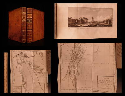
Sold20191799 Voyages in Syria & EGYPT Africa Illustrated MAPS1799 Voyages in Syria & EGYPT Africa Illustrated MAPS Sphinx Pyramids 2v Volney Constantin-François Volney, an 18th-century French philosopher known for his historical works on archaeology and travelSee Sold Price
Sold2017Early Maps and Views of EgyptGroup of early maps and views of Egypt and the Mediterranean, including engraved views of Cairo and Alexandria from Meller's Description de l'Univers (Paris: 1683); Herman Moll, "The East Part of BarbSee Sold Price
Sold2020Early 20th C. Egyptian Wood and Brass Hookah Pipe**Originally Listed At $100** Middle East / North Africa, Egypt, ca. early 20th century CE. A smoking pipe with an acorn-shaped brass body. A wooden stem projects outward from the spout. A knobbed finSee Sold Price
Sold20201787 1st ed Voyages in Syria & EGYPT Africa Illustrated1787 1st ed Voyages in Syria & EGYPT Africa Illustrated MAPS Sphinx 2v Volney “The best expose of Ottoman Empire at the end of the 18th-century!” (Blackmer) Constantin-François Volney, an 18th-ceSee Sold Price
Sold2018Mercator: Antique Map of Egypt and of N Africa, 1578Title/Content of Map: 1578 Mercator Map of Egypt and Parts of N Africa -- Afr. III Tab. Date Printed: 1578 Amsterdam Cartographer: G. Mercator Size: 13.25 x 18 in. This is a detailed map of NortheastSee Sold Price
Sold20191854 Journey to Central Africa EGYPT Sudan Ethiopia MAP1854 Journey to Central Africa EGYPT Sudan Ethiopia MAP Nile Bayard Taylor Bayard Taylor was a 19th-century travel writer whose abundant notes and reports have been referenced for decades since the miSee Sold Price
May 09Hunt and Peck Estate Services, Inc.G. De L'Isle/Covens & Mortier Map Of Egypt, Nubia, And Abissinia$140
May 12Schilb Antiquarian Rare Books1859 AFRICA VOYAGES Barth Timbuktu Tripoli SLAVES Illustrated Slavery MAP African$62(4 bids)
5 days LeftJasper521816 VOYAGE TO ABYSSINIA by HENRY SALT w/ MAP antique 1st AMERICAN EDITION rare$400
2 days LeftTrillium Antique Prints & Rare BooksDavid Roberts - Grand Approach to the Temple of Philae, Nubia$200
2 days LeftTrillium Antique Prints & Rare BooksBraun & Hogenberg, pub. 1575 - View of Cairo, Egypt$100
2 days LeftTrillium Antique Prints & Rare BooksPtolemy & Magini, pub. 1620 - Map of the World with Six Windheads$130(4 bids)
2 days LeftTrillium Antique Prints & Rare BooksPtolemy & Magini, pub. 1620 - Double Hemisphere Map of the World$400(5 bids)
4 hrs LeftAlbion AuctionsRoberts, David 1856 Print. View Looking across the Hall of Columns 182$20(3 bids)
May 16Potter & Potter AuctionsMap to Acquaint You with the Great Mission Bay Project. 194...$125(1 bid)