Sold2022BANNERMAN; LODGE. BIRDS OF THE BRITISH ISLES. 12VBannerman, David Armitage; Lodge, George E. [illustrator] THE BIRDS OF THE BRITISH ISLES. 12 volumes. Edinburgh: Oliver and Boyd, 1953. 1st edition. * 12 quartos in uniform binding. Full green cloth.See Sold Price
Sold2024§ SIR BRIAN CLARKE (BRITISH 1953-)SIR BRIAN CLARKE (BRITISH 1953-) THE PLUMB WINDOW II, 1974 vertical window screen, mouth-blown English, French Antique and Belgian Opal glass with mirrors, cut and leaded approximately 192.5cm x 58.5cSee Sold Price
Sold2022BRITISH ISLES LILY (GEORGE) Britanniae insulae quae nunc Angliae et Scotiae regna continet cum H...BRITISH ISLES LILY (GEORGE) Britanniae insulae quae nunc Angliae et Scotiae regna continet cum Hibernia adiacente nova descriptio, double-page engraved map, land masses hand-coloured, title cartoucheSee Sold Price
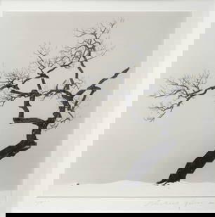
Sold2023Michael Kenna (British, 1953)Kussharo Lake Tree, Study 1, Kotan, Hokkaido, Japan - 2002 Silverprint, 19,4 x 20 cm Signed and dated lower right on the mount Edition number lower left on the mount: 10/45 Provenance: Box Galerie, BrSee Sold Price
Sold2022British Isles.- Ortelius (Abraham) Britannicarum Insularum Vetus Descriptio, two-sheet map ofBritish Isles.- Ortelius (Abraham) Britannicarum Insularum Vetus Descriptio, two-sheet map of ancient Britain, probably engraved by Jan Wierix, with four ornate strap-work cartouches, a naval battle iSee Sold Price
Sold2022British Isles.- Taylor (Thomas) England Exactly Described or a Guide to Travellers, In a CompleatBritish Isles.- Taylor (Thomas) England Exactly Described or a Guide to Travellers, In a Compleat Sett of Most Correct Mapps of Counties in England ... according to Mr. Ogilby's Survey, double page tiSee Sold Price
Sold2024[British Isles] [King James I]: The Workes of the Most High and Mightie Prince, James by the Grace[British Isles] [King James I]: The Workes of the Most High and Mightie Prince, James by the Grace of God, King of Great Britaine, France and Ireland, Defender of the Faith, &c The Workes of the MostSee Sold Price
Sold2020British Isles.- Speed (John) Britain as it was DevidedBritish Isles.- Speed (John) Britain as it was Devided in the Tyme of the English Saxons especially during their Heptarchy, decorative map of the British Isles with compass rose and numerous rhumb linSee Sold Price
Sold2022BRITISH ISLES SPEED (JOHN) The Kingdome of Great Britaine and Ireland, J. Sudbury and George Hum...BRITISH ISLES SPEED (JOHN) The Kingdome of Great Britaine and Ireland, hand-coloured double-page engraved map, inset views of London and Edinburgh, decorated with putti, ships, compass and scale, RoySee Sold Price
Sold2023British Isles.- Speed (John) Britain as it was devided in the tyme of the Englishe Saxons especiallyBritish Isles.- Speed (John) Britain as it was devided in the tyme of the Englishe Saxons especially during their Heptarchy, decorative map of the British Isles with compass rose and numerous rhumb liSee Sold Price
Sold2022Anna Richards Brewster "Lake Shore, Derwentwater (British Isles)", 1925Oil on board. Unsigned with hand-written notes with title preserved verso. Framed: 10 1/2" x 13". Trained first with father William Trost Richards, later with W. Merritt Chase & LaFarge. In 2008, exhiSee Sold Price
Sold20241987 British Isles Proof Gold 1/4 ounce Angel Coin1987 British Isles Proof Gold Angel Coin. 3x3x1 in.See Sold Price
Sold20241987 British Isles Proof Gold 1/4 ounce Angel Coin1987 British Isles Proof Gold Angel Coin. 3x3x1 in.See Sold Price
Sold2017Keulen: Antique Map of the British Isles, 1678Map: British Isles Date Printed: 1678-1682 Cartographer: J Keulen Material/Medium: Paper Size: 21" x 24" Printed on thick paper. Double page map. Rare map of the British isles with north oriented to tSee Sold Price
Sold2021Jansson 1653 Map of British IslesDESCRIPTION: " Magnae Brittaniae et Hiberniae Nova Descriptio. " Based on Willem Blaeu's 1631 map of the British Isles, this map depicts towns, rivers, an inset of Orkney Islands. Strap work cartoucheSee Sold Price
Sold2020British Isles.- Ortelius (Abraham) Angliae, Scotiae, etBritish Isles.- Ortelius (Abraham) Angliae, Scotiae, et Hiberniae, sive Britannicar Insularum Descriptio, Ortelius' earliest map of Britain, oriented with north to the right, and embellished with twoSee Sold Price
Sold20241987 British Isles Proof Gold 1/4 ounce Angel Coin.1987 British Isles Proof Gold Angel Coin. 3x3x1 in.See Sold Price
Sold20241987 British Isles Proof Gold 1/4 ounce Angel Coin1987 British Isles Proof Gold Angel Coin. 3x3x1 in.See Sold Price
Sold20241987 British Isles Proof Gold 1/4 ounce Angel Coin1987 British Isles Proof Gold Angel Coin. 3x3x1 in.See Sold Price
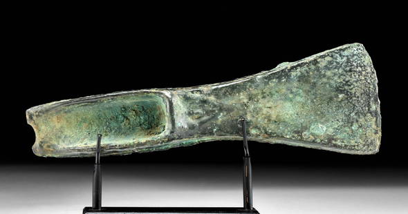
Sold2023Ancient British Isles Bronze Palstave Axe HeadAncient Northern Europe, British Isles, Atlantic Bronze Age, ca. late 2nd to early 1st millennium BCE. A mold-cast bronze axe head of sturdy design with a flared blade head and a hafting wedge meant tSee Sold Price
Sold2018Munster: Antique Ptolemaic Map of British Isles, 1570Title: Britannischen Insula. 1570 woodcut Ptolemaic map of the British Isles Map maker: Sebastian Münster Place and Year: Basel, 1570 Dimensions: 25.0 x 16.5 cm (9.8 x 6.5 in) Technique: Woodblock prSee Sold Price
Sold2019British Isles.- Mercator (Gerard) & Henricus Hondius.British Isles.- Mercator (Gerard) & Henricus Hondius. Anglia, Scotia et Hibernia, engraving with hand-colouring on laid paper, platemark 340 x 425 mm. (13 1/2 x 16 3/4 in), sheet 445 x 550 mm. (17 1/2See Sold Price
Sold2020[British Isles] [Victoria] Holmes, Richard R., Queen[British Isles] [Victoria] Holmes, Richard R. Queen Victoria New York: Century, 1897. #XCVI [96] of 100 numbered copies. Large 4to, original full brick red morocco, gilt-lettered spine, top edges giltSee Sold Price
Sold2023Tessa Pullan (British, 1953), a pair ofTessa Pullan (British, 1953), a pair of plaster maquettes of horses in the Art Deco style, one signed with initials and dated 1982 verso, 51 by 90cm (2). Note: from 1971-1974 Tessa Pullan was apprentiSee Sold Price
5 days LeftJasper521824 Cary Map of the British Isles -- Cary's Reduction of his Six Sheet Map of the British Isles;$320
2 days LeftTrillium Antique Prints & Rare BooksPtolemy & Magini, pub. 1620 - Map of the British Isles (England, Scotland, Ireland) / Verso: Map of$50(1 bid)
Featured6 days LeftJasper52PACIFIC OCEAN currents British French German US Spanish colonies. LETTS 1889 map$15
3 days LeftClaydon Auctioneers LtdBooks: A quantity of books on the subject of nature to include Wayside and Woodland Blossoms, by£50


![BANNERMAN; LODGE. BIRDS OF THE BRITISH ISLES. 12V: Bannerman, David Armitage; Lodge, George E. [illustrator] THE BIRDS OF THE BRITISH ISLES. 12 volumes. Edinburgh: Oliver and Boyd, 1953. 1st edition. * 12 quartos in uniform binding. Full green cloth.](https://p1.liveauctioneers.com/8124/269413/141095076_4_x.jpg?height=310&quality=70&version=1669075360)


![[British Isles] [King James I]: The Workes of the Most High and Mightie Prince, James by the Grace: [British Isles] [King James I]: The Workes of the Most High and Mightie Prince, James by the Grace of God, King of Great Britaine, France and Ireland, Defender of the Faith, &c The Workes of the Most](https://p1.liveauctioneers.com/65/316312/169664667_1_x.jpg?height=310&quality=70&version=1705454340)


![[British Isles] [Victoria] Holmes, Richard R., Queen: [British Isles] [Victoria] Holmes, Richard R. Queen Victoria New York: Century, 1897. #XCVI [96] of 100 numbered copies. Large 4to, original full brick red morocco, gilt-lettered spine, top edges gilt](https://p1.liveauctioneers.com/65/159076/80332969_1_x.jpg?height=310&quality=70&version=1578427354)


