Sold20222 E. Bowen Maps of Italy & GreeceEmanuel Bowen, Welsh, 1694-1767. Two 18th century hand-colored engraved maps. Includes one titled "Middle or Proper Italy" and another titled "A Map of Great Greece and the Islands of Sardinia and CorSee Sold Price
Sold20222 Antique Maps of Saltzberg & Swiss AlpsTwo 18th century hand-colored engraved maps. Includes one titled "Saltzberg" by Gabriel Bodenehr and another titled "La Descente du Cote du Midi des Alpes" (The Descent on the South Side of the Alps)See Sold Price
Sold2023Antique Map of HispaniolaAntique Map of Hispaniola, "Hispaniolae, Cubae...", Ortelius, late 17th/early 18th c., hand-colored engraved map, sight 15 in. x 21 1/2 in., framedSee Sold Price
Sold2021Map of City and Harbour of MacauA Plan of the City and Harbour of Macao" engraved by B. Baker, Islington 27" x 20 1/2" (sight) hand-colored engraved map 18th century framed- 32 1/2" x 40See Sold Price
Sold201818th C. Milan Ducatus Mediterranean Map18th C. framed copper engraved map, hand colored of Milan, Genoa, Lake Como and Mantua Cartouche. By Matthai Serteri, S.C.M. GEOGR Augustani. Visible paper measures approximately 20.25" H X 24" W, witSee Sold Price
Sold201818th C. Map of Australia w/Strait of Magellan18th c. framed map of Australia w/the Strait of Magellan. Copper engraved map, hand colored, w/ large colored pictorial cartouche, by Bernaidus Joannis Manasterienfis. Visible paper measures approximaSee Sold Price
Sold2016Two Framed Hand-colored Engraved Maps, 19th/20thTwo Framed Hand-colored Engraved Maps, 19th/20th Century, Including a map of Morea olim Peloponnesus by Gerardus Mercator and of Deventer by Johannes Blaeu. Largest framed dimensions: h: 21 1/2 x w: 2See Sold Price
Sold2020Group of French Maps Guillaume de l'Isle SansonGroup of four 17th and 18th century French maps. Guillaume Delisle (1675-1726) hand colored engraved map of Picardie, 1748. Two maps by Nicolas Sanson (1600-1677), "Le Roayaume de France" and "GouvernSee Sold Price
Sold2023Two American 18th century maps from the Gentleman's Magazine.Two American 18th century hand colored maps from the Gentleman's Magazine. The first, "The Hudson River" published in 1778 - very good condition, professionally framed and matted - total frame size 13See Sold Price
Sold2017Two 18th century engraved maps with hand coloringHind, Hindoostan, or India. Louis de la Rochette. Engraved map with hand color in part. London: W. Faden, c. 1790-1811. 31 x 23 inches framed. AND Africae in Tabula Geographica Delineatio. Adam FriedrSee Sold Price
Sold2021"Terra FIrma and Caribbe Islands", Emanuel Bowen"A New and Accurate Map of the Terra Firma and the Caribbe Islands", an 18th century map by Emanuel Bowen (1693-1767). An engraved and hand colored map in two pages with central fold crease, framed. 1See Sold Price
Sold202218th C. MAPS OF NORTH AMERICA & CARIBBEAN (2 MAPS)Includes: Brian de la Tour, Louis. L'AMERIQUE DRESSEE POUR L'ETUDE DE LA GEOGRAPHIE (Paris, 1764).Copperplate engraved map of North and South America. Hand colored. Matted and framed. H. 11", W. 12" BSee Sold Price
Sold2021PAIR, 18TH C. HAND-COLORED SPORTING ENGRAVINGSafter James Gwyn (British, 1700-1769). Two hand-colored fencing engravings, engraved by Hall circa 1760. Framed as a pair. Approx. 20.25" x 25.25" (frame) 10.75" x 15.75" (sight)See Sold Price
Sold2021Jacobus Keizer 18th C.Dutch engraved Map of NorthThis 18th Century map of North America is written in Dutch (possibly a bookplate) is a hand colored copper engraving by noted Dutch Cartographer Jacobus Keizer 1710-1745. Quality matted and framed, itSee Sold Price
Sold2021(2) 18TH C. BRITISH FISHING AQUATINTSTwo hand-colored aquatints engraved by Jutes after Walmsley. From Views of Llangoloen. Published 1794. Dimensions: (Frame) H 22" x W 25.5", (Sight) H 18.5" x W 22.5" Condition: Full sheet framed, no mSee Sold Price
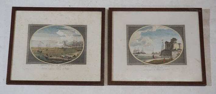
Sold202318th Century Engravings of Charleston & SavannahBy Claude Joseph Vernet engraved in London 1780. Two very nicely rendered and hand colored examples. Each with well defined plate lines and nice bold colors throughout. Framed: H11 1/8" W13 1/4" RecenSee Sold Price
Sold201718th Century French Map of North AmericaL’Amerique Septentrionale. Daniel de la Feuille (1640-1709). Engraved map with hand color in full. Amsterdam, 1702 or 1706. 6 x 8 inches visible, 13 x 14 1/2 inches framed. Nicely colored early 18thSee Sold Price
Sold201818TH C. HANDCOLORED ENGRAVED MAP OF AMSTERDAMDimensions: (Frame) H 15.75" x W 16", (Sight) H 9.75" x W 10.25" Condition: Some age toning and spotting.See Sold Price
Sold201918th C. Hand-colored Bird Engravings PHEASANT & OWLTwo framed 18th century hand-colored Bird Engravings. 1) Otus Americanus - Eurasian Eagle Owl. Johann Michael Selgmann after George Edwards Natural History of Birds 1770. Copper engraving with hand coSee Sold Price
Sold201918th C. Hand-colored Bird Engravings Quail & PetrelTwo framed 18th century hand colored engravings. 1) Madagascar Button Quail. Histoire Naturelle des Oiseaux 1770-1786, Paris. Hand-colored copper engraving by Francois-Nicolas Martinet. 2) Northern GiSee Sold Price
Sold2023ANTIQUE 18TH C HAND COLORED MAP OF OTTOMAN EMPIREAn antique early 18th-century hand-colored engraved map representing the Ottoman Empire. Published in Nuremberg, Germany, 1720. Titled Imperium Turcicum, technical information in Latin in the lower leSee Sold Price
Sold202118th c. H/C Map Flamsteed and Fortin 177618th Century hand-colored engraved Celestial Map / Zodiac Map Entitled Le Lynx, Le Petit Lion (Lynx, Small Lion), plate 5, from "Atlas Céleste de Flamstéed, approuvé par l'Académie Royale des ScieSee Sold Price
Sold2022(TRANSYLVANIA.) Two 17th-century hand-colored engraved maps of central Romania.(TRANSYLVANIA.) Two 17th-century hand-colored engraved maps of central Romania. Amsterdam, 1630s - Mercator/Hondius. Transylvania. 18x21¼ inches sheet size, wide margins, German text on verso; liSee Sold Price
Sold2023Sauthier & Fadden Revolutionary War Map EngravingAn original 18th Century hand colored engraved topographical map, illustrated by Claude Joseph Sauthier (1736–1802) and published by William Faden (1749-1836), the latter serving as royal geogrSee Sold Price
May 19The Heritage Gallery at Sayville Antiques, Inc4 Persian Religious Hand Drawn Manuscripts 16th - 18th c.$50
May 14Fleischer's Auctions1755 Map Partie de l'Amerique Septentrionale, qui comprend Le Cours de L'Ohio...$200(3 bids)
BonhamsSEUTTER, MATTHÄUS. 1678-1757. And TOBIAS CONRAD LOTTER. 1717-1777. Recens edita totius Novi...$950(2 bids)
BonhamsZATTA, ANTONIO. 1757-1797. La Pensilvania, la Nuova York, il Jersey settentrio[na]le.... Venice:...$120(9 bids)
195 Lots AwayForum AuctionsVirgilius Maro (Publius) The Georgicks...with an English Translation and Notes. By John Martyn,£150
2 days LeftJeffrey S. Evans & AssociatesJOHN DADLEY (ENGLISH, 1767-1817) AFTER PU-QUA (CHINESE, 18TH CENTURY) "THE COSTUME OF CHINA" PRINTS,$100
May 09Hunt and Peck Estate Services, Inc.ANTONIO ZATTA (ITALIAN, 18TH CENTURY) MAP OF VIRGINIA$70(1 bid)
May 10Crescent City Auction GalleryAfter Pieter Casteels III (Flemish/London, 1684-1749), Four Vintage Hand-Colored Engravings after$325


![ZATTA, ANTONIO. 1757-1797. La Pensilvania, la Nuova York, il Jersey settentrio[na]le.... Venice:... (1 of 3)](https://p1.liveauctioneers.com/1043/324005/175444948_1_x.jpg?height=282&quality=70&version=1713980374)


