Sold2023Britannica International Atlas 1966, illustrated, Geography, History, Maps"Encyclopaedia Britannica International Atlas. Political-Physical Maps, World Distributions and World Political Geography, Geographical Summaries, Geographical Comparisons, Glossary and Index to PolitSee Sold Price
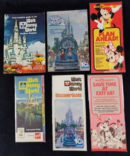
Sold2021Six Vintage Walt Disney World Maps GuidebooksThis lot includes: (1) Walt Disney World 1973 Spring/Summer Information Guide. (1) Walt Disney World Discover Guide. Oct 1, 1981 to Sept 30, 1982. (1) "Save Time At Exit 68"! Information Center Card.See Sold Price
Sold2019Cortambert, Eugene 1874 Lot of 4 Maps. UK, World EuropeTwo of the British Isles, Europe Physical Map and World on Mercators Projection. Hand Coloured Lithograph Maps Published 1874, Paris for "Atlas de la Geographie de L'Europe" by Eugene Cortambert. PapeSee Sold Price
Sold2019Rare 1st ed. 1847 ethno map of Europe/AsiaA large full color map of Europe and Asia showing the ethnographic distribution of people. Includes an accompanying chart. From the first comprehensive physical atlas of the world. This map comes fromSee Sold Price
Sold2019Rare 1st ed./1st state decorative map, 1848From the first comprehensive physical atlas of the world. This map comes from the rare first edition/first state of “Physikalischer Atlas oder Sammlung von Karten” by Heinrich Berghaus. Full titleSee Sold Price
Sold2023COLLECTION VINTAGE PENNANTS / MAPSCollection of pennants and maps including; 1964-5 World's Fair, Six Flags-Georgia, Mt. Vernon, Staten Island Zoo, Hershey Pa, Niagara Falls, West Point, etcSee Sold Price
Sold2021Hall, Sidney C1850 Pair of World Maps. Hemisphere etc"The World" Hemispheres and "Map of the World Exhibiting the Chief Physical Features of the Earth" Steel Engraved Maps Published C1850, London for "A Grammar of General Geography..." by the Rev. J. GoSee Sold Price
Sold20201890 c. World Climate Map -- Isothermal Curves andTitle/Content of Map: 1890 c. World Climate Map -- Isothermal Curves and Zones of Physical Climate Cartographer: Anonymous Year/Place: 1890 c. Size: 10.4 x 17.7 in. This is a very interesting world maSee Sold Price
Sold2022Map of the World, Exhibiting the Chief Physical Features of The Earth,Publication Date: c1865 Title: Map of the World, Exhibiting the Chief Physical Features of The Earth, Cartographer: WELLER, EDWARD Publisher: LONGMAN & CO. Height: 8.1 Width: 14.5 "with the distributiSee Sold Price
Sold2021Vintage Crams Physical Political Map of the WorldVintage Crams Physical Political Map of the World C-69. Used condition, wear, worn. 67 1/2" wideSee Sold Price
Sold2021Maps 19th Cent. Mixed Lot of 6 MapsIncl Rome, Rio de Janeiro, England/Wales, Europe in the 7th/9th/12th century, Physical Map of Europe, and France. Examples by Fullarton and Chambers. Six sheets containing 8 maps (Two of the ChambersSee Sold Price
Sold2022LOT OF AMERICAN WWII MILITARY PROPAGANDA POSTERSA collection of six American WWII military propaganda posters Newsmap Armed Forces, 1943 - 1945. The posters contain information about the progress of the war, photographs and maps. World War II And ASee Sold Price
Sold2016US Cold War Skull & North Pole Map 26th SquadronAmerican Cold War Stein 1/2L Porcelain. “Patrol Squadron Twenty Six, Top of the World 1956.” Skull and North Pole map. Mint.See Sold Price
Sold2023The Second World War, Six Volumesby Winston Churchill, London: Cassell & Co., Ltd., 1948-1954, six volumes (complete), with numerous charts, maps, and diagrams, some folding, bound in half tan and brown leather, gilt lettering and deSee Sold Price
Sold20201854 BlackTitle/Content of Map: 1854 Black's Illustration of World Mountains and Rivers -- Physical Geography Cartographer: A & C Black Year/Place: 1854, Edinburgh Size: 10 X 14.5 in. This is a very attractiveSee Sold Price
Sold2018Mission of the North American People w/6 color mapsHeading: Author: Gilpin, William Title: Mission of the North American People, Geographical, Social, and Political. Illustrated by Six Charts Delineating the Physical Architecture and Thermal Laws ofSee Sold Price
Sold2020Philip, George C1900 Mixed Lot of 8 MapsIncl Asiatic Russia, Asia-Physical, France - North, France - Physical, Mediterranean, North Atlantic, Commercial Chart of the World, and Climatological. Lithograph Maps Published C1900, London for "PhSee Sold Price
Sold2019Rhind, William 1844 Rare Map of the Old World. EarthAquatint Map Published 1844, London "The Creation: Illustrated By Six Engravings On Steel" by William Graeme Rhind. Rare. Paper Size: 6.5 x 6 inch (16.5 x 16cm) Very minor margin toning, slightly affeSee Sold Price
Sold2023Scarce vintage map of the Deep South, 1875J. David Williams’ map of southern states from the very scarce Jones & Hamilton Atlas of the World Illustrated. Shows the six states that comprise the extreme southeastern United States. WonderfullySee Sold Price
Sold2021MAPS IN BOOK, Geography Books, ColtonGeography Books. Joseph Hutchins Colton, J.H. Colton's American School Quarto Geography, Comprising the Several Departments of Mathematical, Physical, and Civil Geography..., 1865 (published). Hand CoSee Sold Price
Sold2019Six (6) Vintage Prints of MapsLot of Six (6) Vintage Prints of Maps. Images of central Europe, atlas of the world, British colonies in North America, France, and Europe. Size range from 20-3/4 x 26-3/4" W to 15-3/4" H x 13-5/8" W.See Sold Price
Sold2022Vintage AJ Nystrom & Co Pull Down Schoolroom MapsFour Vintage Pull Down School Room World Mapspublished by A.J. Nystrom & Co, Chicago. Landform Physical + Political Series.See Sold Price
Sold2019Gross, Alexander 1920 Pair of Maps of North AmericaNorth America Physical and Political. Large Lithograph Maps Published 1920, London for "The Daily Telegraph Victory Atlas of the World" by Alexander Gross. Centre fold as published. Paper Size: 25 x 1See Sold Price
Sold2019Gross, Alexander 1920 Pair of Large Maps. AfricaAfrica Political and Physical. Large Lithograph Maps Published 1920, London for "The Daily Telegraph Victory Atlas of the World" by Alexander Gross. Centre fold as published. Paper Size: 25 x 19.5 incSee Sold Price
3 days LeftTrillium Antique Prints & Rare BooksPtolemy & Magini, pub. 1620 - Map of the World with Six Windheads$130(4 bids)
May 02The Rug LifeTHE SECOND WORLD WAR AND HISTORY OF ENGLISH-SPEAKING PEOPLE, BOTH BY SIR WINSTON CHURCHILL. 9$300
3 days LeftTrillium Antique Prints & Rare BooksPrichard - 7 Native American Aquatint Engravings$35(1 bid)
3 days LeftArtMeetsStreet x Mercer AuctionsLUNA LUNA - OFFICAL PROGRAM (HARING, BASQUIAT, LICHTENSTEIN, DALI)$50
1 day LeftA & A Auction Gallery(40)Asst 1940s-50s Army Corps World Maps - Most 1:1,000,000 Scale Maps From Arount The World,$60
1 day LeftA & A Auction Gallery(41)1940s-50s Army Corps World Maps - Army Map Services, Secretary of Navy, (1)Declassified$60
6 days LeftJasper521699 Moll World Map with Cowley's Voyages -- Nouvelle Carte du Monde Suivant l'idee de Mercator ou$240
Featured6 days LeftJasper521719 Chatelain World Map -- Mappe-Monde pour Connoitre les Progres & les Conquestes les Plus$280