Sold20201855 Colton Map of Boston -- Map of Boston and AdjacentTitle/Content of Map: 1855 Colton Map of Boston -- Map of Boston and Adjacent Cities Date: 1855, New York Cartographer: J ColtonSize: 14.7 X 12 in. This is a very attractive city map. It is full of deSee Sold Price
Sold2019Map of Boston and adjacent cities.Title: Map of Boston and adjacent cities. Publication Date: 1856 Publisher: J. H. Colton & Company Dimensions: 15.6 X 11.75 Additional Information: First edition. Decorated border.Edges browned. ReserSee Sold Price
Sold2021Antique Boston and Adjacent Cities EngravingMap of Boston and adjacent cities published by J.H Colton & Co, created in 1865, label to center right reads ‘Map of Boston and Adjacent Cities. Published by J.H. Colton & Co. N172 William ST NewSee Sold Price
Sold20191861 & 1855 Maps of Boston(1) 1861 map by W. C. Sharp, Boston. Advertising to reverse. Fold crease separations, some with tape repairs. 10 1/2" x 11 1/4" approx. (2) 1855 map engraved by G. W. Boynton. Very good condition; ageSee Sold Price
Sold2017Colton: Antique Map of Boston, 1861Title/Content of Map: Boston by Colton Date Printed: 1861 Cartographer: J.H. Colton Material/Medium: Paper Size: 14" x 17 1/4" Hand colored, steel engraved. From Colton's 'General Atlas'. Published inSee Sold Price
Sold20183 Maps incl: Map Of Boston And Adjacent Cities.[World/ Massachusetts/Europe] 3 Maps. ++ A New Map Of The World On The Globular Projection. Phila: Thomas, Cowperthwait & Co., (1850). Hemispheres. Outer edge of overall border: 9 1/2 x 14 1/8 in. TonSee Sold Price
Sold20171886 Williams Pocket Map of Greater BostonTitle: 1886 Williams Pocket Map of Greater Boston -- Map of Boston and the Country Adjacent, from Actual Surveys Cartographer: A Williams Origin/Date: 1886, Boston Size: 31 inches x 21 inches folded oSee Sold Price
Sold20181855 Colton Map of New York City and Parts of BrooklynReserve Reduced! Title/Content of Map: 1855 Colton Map of New York City and Parts of Brooklyn -- Map of New York and the Adjacent Cities Date: 1855, New York Cartographer: J Colton Size: 15.5 X 25.1 iSee Sold Price
Sold20231859 Map of Boston and surrounding communities by ColtonTitle: 1859 Map of Boston and surrounding communities by Colton Date/Period: 1859 Materials: Steel engraved Size: 17 1/2 x 14 1/2” br>Boston and surrounding communities. Shows, rivers, lakes, coSee Sold Price
Sold2022FINE REPRODUCTION MAP OF ANTEBELLUM BOSTONGeorge C. Smith's 1855 "Plan of Boston Comprising a Part of Charlestown and Cambridge", from the Collection of Norman B. Leventhal, Presented to Members of the MIT Class of 1938, on the Occasion of thSee Sold Price
Sold20242 19th Century New York Maps Gamble & Colton2 19th century maps of New York. Colton's Map of New York and the Adjacent Cities, J.H. Colton 1855, 16 1/4" x 26 1/4" (with frame 28 1/8" x 38"); County Map of the State of New York, W.H. Gamble, 187See Sold Price
Sold2022Great Colton map of MissouriExcellent 1855 first edition example of Colton's map of Missouri. Covers the entire state as well as adjacent parts of Illinois and Kansas. In Kansas, various Indian tribes are noted including the CheSee Sold Price
Sold2021Massachusetts and Rhode IslandPublication Date: 1856 Title: Massachusetts and Rhode Island Cartographer: COLTON, J.H. Publisher: J.H. COLTON & CO. Height: 11 Width: 15.5 Detailed map with inset of Vicinity of Boston. Shows countieSee Sold Price
Sold20231859 Map of Massachusetts and Rhode Island. Insert of Boston by ColtonTitle: 1859 Map of Massachusetts and Rhode Island. Insert of Boston by Colton1859 Materials: Steel engraved Size: 17 1/2 x 14 1/2” Massachusetts and Rhode Island. With insert of Boston and surroundiSee Sold Price
Sold20221926 Olsen and Clarke Map of Boston -- The Colour of an Old City - A Map of Boston Decorative andTitle: 1926 Olsen and Clarke Map of Boston -- The Colour of an Old City - A Map of Boston Decorative and Historical Cartographer: Olsen and Clarke Year / Place: 1926, Boston Map Dimension (in.): 28.3See Sold Price
Sold20231938 R Taylor White Pictorial Map of Hawaii and Samoa -- Territory of Hawaii [with] SamoaTitle: 1938 R Taylor White Pictorial Map of Hawaii and Samoa -- Territory of Hawaii [with] Samoa Cartographer: Ruth Taylor White Year / Place: 1938, Boston Map Dimension (in.): 11.6 x 8.5 in. This isSee Sold Price
Sold20221938 R Taylor White Pictorial Map of Texas -- TexasTitle: 1938 R Taylor White Pictorial Map of Texas -- Texas Cartographer: Ruth Taylor White Year / Place: 1938, Boston Map Dimension (in.): 11.6 x 8.5 in. This is Ruth Taylor White's charming pictorialSee Sold Price
Sold20211938 R Taylor White Pictorial Map of Texas -- TexasTitle: 1938 R Taylor White Pictorial Map of Texas -- Texas Cartographer: Ruth Taylor White Year / Place: 1938, Boston Map Dimension (in.): 11.6 x 8.5 in. This is Ruth Taylor White's charming pictorialSee Sold Price
Sold20211938 R Taylor White Pictorial Map of the PhilippineTitle: 1938 R Taylor White Pictorial Map of the Philippine Islands -- Philippine Islands Cartographer: Ruth Taylor White Year / Place: 1938, Boston Map Dimension (in.): 11.6 x 8.5 in. This is Ruth TaySee Sold Price
Sold20211838 Bradford Map of Indiana -- IndianaTitle: 1838 Bradford Map of Indiana -- Indiana Cartographer: T Bradford Year / Place: 1838 Boston Map Dimension (in.): 14.2 x 11 in. This is a nice and highly detailed state map. The counties are coloSee Sold Price
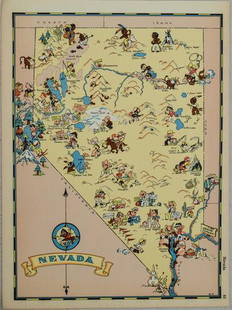
Sold20211938 R Taylor White Pictorial Map of Nevada -- NevadaTitle: 1938 R Taylor White Pictorial Map of Nevada -- Nevada Cartographer: Ruth Taylor White Year / Place: 1938, Boston Map Dimension (in.): 11.6 x 8.5 in. This is Ruth Taylor White's charming pictoriSee Sold Price
Sold20211938 R Taylor White Pictorial Map of Massachusetts --Title: 1938 R Taylor White Pictorial Map of Massachusetts -- Massachusetts Cartographer: Ruth Taylor White Year / Place: 1938, Boston Map Dimension (in.): 11.6 x 8.5 in. This is Ruth Taylor White's chSee Sold Price
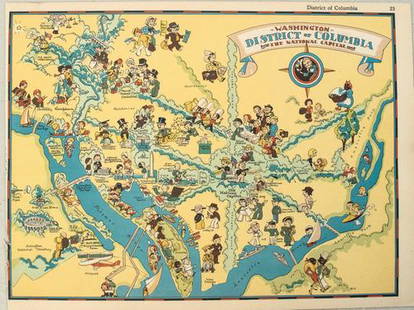
Sold20211938 R Taylor White Pictorial Map of Washington D.C. --Title: 1938 R Taylor White Pictorial Map of Washington D.C. -- Washington District of Columbia the National Capital Cartographer: Ruth Taylor White Year / Place: 1938, Boston Map Dimension (in.): 11.6See Sold Price
Sold20211938 R Taylor White Pictorial Map of the United StatesTitle: 1938 R Taylor White Pictorial Map of the United States -- The United States of America Cartographer: Ruth Taylor White Year / Place: 1938, Boston Map Dimension (in.): 11.6 x 8.5 in. This is RutSee Sold Price
Featured5 days LeftJasper521869 RR map of Missouri from elusive edition of Colton’s atlas$45(2 bids)
16 hrs LeftRapid Estate Liquidators and Auction GalleryReprint From The Original Coltons Map 1855 No.30 Copyright 1967$20
May 16Potter & Potter AuctionsBODLEY, Helen (1906 – 1997). A Map of Concord / The Old Mus...$400


![3 Maps incl: Map Of Boston And Adjacent Cities.: [World/ Massachusetts/Europe] 3 Maps. ++ A New Map Of The World On The Globular Projection. Phila: Thomas, Cowperthwait & Co., (1850). Hemispheres. Outer edge of overall border: 9 1/2 x 14 1/8 in. Ton](https://p1.liveauctioneers.com/179/117971/60557739_1_x.jpg?height=310&quality=70&version=1520636872)


![1938 R Taylor White Pictorial Map of Hawaii and Samoa -- Territory of Hawaii [with] Samoa: Title: 1938 R Taylor White Pictorial Map of Hawaii and Samoa -- Territory of Hawaii [with] Samoa Cartographer: Ruth Taylor White Year / Place: 1938, Boston Map Dimension (in.): 11.6 x 8.5 in. This is](https://p1.liveauctioneers.com/5584/274166/143946169_1_x.jpg?height=310&quality=70&version=1673389176)