Sold20191844 Pacific Voyages D’Urville Australia MAP Magellan1844 Pacific Voyages D’Urville Australia MAP Magellan Cook Anson Vancouver MAPS Jules Dumont D’Urville was a 19th-century French explorer who is best known for his voyages in the South Pacific andSee Sold Price
Sold20201834 Pacific Voyages D’Urville Australia Magellan Cook1834 Pacific Voyages D’Urville Australia Magellan Cook Anson Vancouver MAPS Jules Dumont D’Urville was a 19th-century French explorer who is best known for his voyages in the South Pacific and AntSee Sold Price
Sold20191830 D’Urville Pacific Voyages Illustrations Australia1830 D’Urville Pacific Voyages Illustrations Australia Tahiti MAPS Hawaii Jules Dumont D’Urville was a 19th-century French explorer who is best known for his voyages in the South Pacific and AntarSee Sold Price
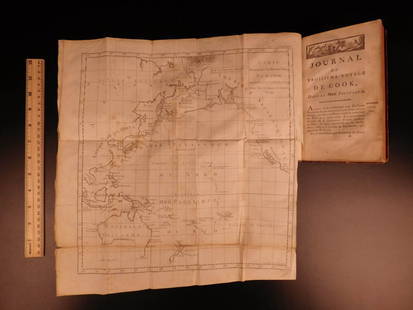
Sold20241783 Captain James Cook Third Pacific Voyage Illustrated MAP Australia Rickman1783 Captain James Cook Third Pacific Voyage Illustrated MAP Australia Rickman “Remember, the greater the opportunity, the fewer are those who see it.” – James Cook James Cook was an 18th-ceSee Sold Price
Sold20191783 Captain James Cook Third Pacific Voyage Illustrate1783 Captain James Cook Third Pacific Voyage Illustrated MAP Australia Rickman “Remember, the greater the opportunity, the fewer are those who see it.” – James Cook James Cook was an 18th-centurSee Sold Price
Sold20221836 1ed Oceania Rienzi Polynesia Voyages MAPS Australia Captain Cook Pacific1836 1ed Oceania Rienzi Polynesia Voyages MAPS Australia Captain Cook Pacific Louis de Rienzi was a 19th-century French voyager who is remembered for his 1836 masterwork Oceania, or Fifth Part of theSee Sold Price
Sold20191836 1ed Oceania Rienzi Polynesia Voyages MAPS1836 1ed Oceania Rienzi Polynesia Voyages MAPS Australia Captain Cook Pacific Louis de Rienzi was a 19th-century French voyager who is remembered for his 1836 masterwork ‘Oceania, or Fifth Part of tSee Sold Price
Sold2022d'Urville, Jules 1834 Map of Tonga, Pacific"Carte des Iles Tonga" Steel Engraved Map Published 1834 by Chez Furne et Ce, Paris for "Voyage pittoresque autour du Monde - Résumé général des voyages de découvertes..." By Jules Dumont d'UrvilSee Sold Price
Sold20211849 Wilkes Pacific US Expedition FIJI MAP Pacific1849 Wilkes Pacific US Expedition FIJI MAP Pacific Islands Australia Illustrated The ‘Wilkes Expedition’ was one of the most important exploration voyages ever taken on by the United States. It heSee Sold Price
Sold20231797 Captain James Cook Pacific Voyages New Zealand Australia Tahiti Tasmania1797 Captain James Cook Pacific Voyages New Zealand Australia Tahiti Tasmania “Remember, the greater the opportunity, the fewer are those who see it.” – James Cook James Cook was anSee Sold Price
Sold2022Times Atlas 1895 Lot of 4 Maps. Australia & PacificLithograph Map Published 1895, London for "The Times Atlas" One with Centre fold as published. Paper Size: Up to 21 x 16 inch (53 x 41cm) The larger map with split on centre fold. Otherwise Good CondiSee Sold Price
Sold2019The Times 1895 Lot of 4 Maps. Australia & PacificLithograph Maps Published 1895, London for "The Times Atlas" Paper Size: 16 x 10.5 inch (41 x 27cm) Good ConditionSee Sold Price
Sold2019Assorted Lg Lot Vintage Map Bookplates. 4 AustralAssorted Lg Lot Vintage Map Bookplates. 4 Australia & Pacific Maps, 5 Amer. city plans mid 19th century incl. New Orleans & Philadelphia. Lg lot of American cities.-- Dimensions: ---See Sold Price
Sold20181886 Australian Pictures Illustrated Australia Voyages1886 Australian Pictures Illustrated Australia Voyages MAP Tasmania Aborigines “Willoughby gave invaluable service with his 'long experience, ripe judgment, clear-sightedness, and fine sense of formSee Sold Price
Sold2018Lapie: Antique Map of Australia & Pacific Islands, 1829Title/Content of Map: Australia & Pacific Ocean Islands Date Printed: 1829 Cartographer: A.E. Lapie Material/Medium: Paper Size: 17 1/2" x 23 1/2" Hand colored. Published in Paris. Pierre M. Lapie (17See Sold Price
Sold2018Tanner: Antique Map of Australia & Pacific Ocean, 1843Title/Content of Map: Australia and Pacific Ocean by Tanner Date Printed: 1843 Cartographer: H.C. Tanner Material/Medium: Paper Size: 17" x 14" Hand colored engraved Map based on the work of H.C. TannSee Sold Price
Sold2018Stieler, Adolf 1874 Map Polynesia & Australia. Pacific"Polynesien und der Grosse Ocean" Steel Engraved Map with outline hand colour Published 1874, Gotha, Germany for "Hand-Atlas über alle Theile der Erde und über das Weltgebäude" by Adolf Stieler. PaSee Sold Price
Sold2020Philip, George C1900 Lot 5 Maps. Australia, NZ PacificLithograph Maps Published C1900, London for "Philips' New Handy General Atlas of the World" by George Philip. Paper Size: 14.5 x 10.5 inch (37 x 27cm) Good ConditionSee Sold Price
Sold20241839. Map of Australia and Pacific by MoninTitle: 1839. Map of Australia and Pacific by Monin Date/Period: 1839 Materials: Hand colored, engraved Size: 17 1/2 x 12 1/2" This is a map of Australia and the Pacific in 1839 when the continent wasSee Sold Price
Sold2022Kelly, Christopher 1816 Map. Pacific Ocean. AustraliaCopper Engraved Map Published 1816, London for "A New and Complete System of Universal Geography" by Christopher Kelly. Maps Engraved by Findlay, Wallis and others. Paper Size: 10 x 8 inch (26 x 21cm)See Sold Price
Sold20171715 MAPS William Dampier Voyages Pacific Islands1715 William Dampier Voyages Illustrated MAPS Pacific Islands Wars Guam Panama An incredible rare and desirable voyages book by William Dampier. This book covers some of the most important and famousSee Sold Price
Sold20184 Maps of Australia & the Pacific 19th Century4 Maps of Australia & the Pacific 19th Century-- Dimensions: ---See Sold Price
Sold20221858 Captain James Cook Voyages Hawaii Pacific1858 Captain James Cook Voyages Hawaii Pacific Australia Kippis Narrative “Remember, the greater the opportunity, the fewer are those who see it.” – James Cook James Cook was an 18tSee Sold Price
Sold20191841 Captain James Cook Voyages Hawaii Pacific1841 Captain James Cook Voyages Hawaii Pacific Australia Kippis Narrative “Remember, the greater the opportunity, the fewer are those who see it.” – James Cook James Cook was an 18th-century BriSee Sold Price
Featured5 days LeftJasper521719 Chatelain World Map -- Mappe-Monde pour Connoitre les Progres & les Conquestes les Plus$280
6 days LeftJasper52Carte réduite de la Mer du Sud'. South Pacific. Australia. BELLIN 1753 map$220
5 days LeftJasper521723 Dampier Map of Voyages to Brazil, Australia and Eat Indies -- Voyage du Cap. Dampier a la N.$280
6 days LeftJasper52PACIFIC OCEAN. Australia New Zealand E.Indies Polynesia Melanesia Japan 1882 map$20
6 days LeftJasper52PACIFIC OCEAN. Australia New Zealand E.Indies Polynesia Melanesia Japan 1886 map$20
6 days LeftJasper52PACIFIC OCEAN Sandwich Islands/Hawaii Australia New Zealand &c. WELLER 1863 map$70
5 days LeftJasper521699 Moll World Map with Cowley's Voyages -- Nouvelle Carte du Monde Suivant l'idee de Mercator ou$240
6 days LeftJasper52Océanique Iles du Scarborough #16 Gilbert Islands Kiribati VANDERMAELEN 1827 map$75
6 days LeftJasper52Nouvelle Caledonie. Baies de Kuakue et de Uinne'. CHAMBEYRON sea chart 1891 map$100
6 days LeftJasper52South west Pacific Ocean Melanesia Polynesia ADMIRALTY sea chart 1875 (1968) map$120
2 days LeftTrillium Antique Prints & Rare BooksWebber & Cook, Rare - View in Macao, Including the Residence of Camoens, when he wrote his Lusiad$500
6 days LeftJasper52Entrée de Norton & Détroit de Bhering. Bering Strait Norton Sound BONNE 1790 map$30
Featured6 days LeftJasper52Entrée de Norton & Détroit de Bhering. Bering Strait Norton Sound BONNE 1788 map$30
6 days LeftJasper52Isles de la Société. Society Islands. Huaheine Raiatea Polynesia. BONNE 1788 map$35
2 days LeftTrillium Antique Prints & Rare BooksWebber & Cook, Rare - The Narta, or Sledge for Burdens in Kamtschatka$500