Sold2020EULER, LEONHARD. [Geographisher Atlas.]EULER, LEONHARD. [Geographisher Atlas.] Without title or text, 39 (of 44) double-page engraved maps with original hand-coloring (lacking the first two double-hemispheric maps, the XVII Provinces, andSee Sold Price
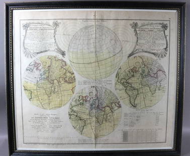
Sold20231747 Leonhard Euler Map of the World with Earth Eclipse & SolarFramed November 1747 Leonhard Euler Map of the World with earth and lunar eclipse including calculated degrees of the eclipse arriving 1748. This would be an important and timely prediction of a majorSee Sold Price
Sold20191783 Engraved Map Stereographic Plane of EquatorEngraved plate showing a Stereographic and an Orthographic map on the plane of the Equator. Published by Harrison and Co., 1783. Fine with mild discoloration, measures 10 x 8". Reserve: $20.00 ShippinSee Sold Price
Sold2020Bonne map of North America 1783Heading: Author: Bonne, Rigobert Title: Amerique Septentionale Place Published: Paris Publisher: Date Published: 1783 Description: Engraved map. 21.5x32.3 cm (8½x12¾").See Sold Price
Sold2015North America with infant United States 1783Heading: Author: Delamarche, Charles François Title: Amérique Septentrionale divesée en ses principaux Etats Place Published: Paris Publisher: Date Published: 1783 Description:See Sold Price
Sold2021Kitchin, Thomas 1785 Antique Map of The West Indies"The West Indies Drawn and Engrav'd from the most approv'd Maps and Charts" Copper Engraved Map Published 1783-85, London for "A New Geographical, Historical and Commercial Grammar..." by William GuthSee Sold Price
Sold2021Kitchin, Thomas 1785 Antique Map of AsiaCopper Engraved Map Published 1783-85, London for "A New Geographical, Historical and Commercial Grammar..." by William Guthrie. Drawn and Engraved by Thomas Kitchin (Kitchen) and John Barber. Rare, ESee Sold Price
Sold2021Barber, John 1785 Antique Map of France & Netherlands"France with the Netherlands Corrected & Improv'd" Copper Engraved Map Published 1783-85, London for "A New Geographical, Historical and Commercial Grammar..." by William Guthrie. Drawn and Engraved bSee Sold Price
Sold2021Kitchin, Thomas 1785 Map of Germany & Netherlands"Germany with the Seven United Provinces" Copper Engraved Map Published 1783-85, London for "A New Geographical, Historical and Commercial Grammar..." by William Guthrie. Drawn and Engraved by ThomasSee Sold Price
Sold2021Kitchin, Thomas 1785 Antique Map of The East IndiesCopper Engraved Map Published 1783-85, London for "A New Geographical, Historical and Commercial Grammar..." by William Guthrie. Drawn and Engraved by Thomas Kitchin (Kitchen) and John Barber. Rare, ESee Sold Price
Sold2021Kitchin, Thomas 1785 Antique Map of Spain & Portugal"Spain and Portugal drawn from the latest and best Authorities" Copper Engraved Map Published 1783-85, London for "A New Geographical, Historical and Commercial Grammar..." by William Guthrie. Drawn aSee Sold Price
Sold2021Barber, John 1785 Antique Map of Russia"Russia or Muscovy in Europe" Copper Engraved Map Published 1783-85, London for "A New Geographical, Historical and Commercial Grammar..." by William Guthrie. Drawn and Engraved by Thomas Kitchin (KitSee Sold Price
Sold2021Kitchin, Thomas 1785 Antique Map of England and Wales"England and Wales with the Roads from the latest Surveys" Copper Engraved Map Published 1783-85, London for "A New Geographical, Historical and Commercial Grammar..." by William Guthrie. Drawn and EnSee Sold Price
Sold2021Barber, John 1785 Antique Map of Turkey & Hungary"Turky in Europe &c. Hungary" Copper Engraved Map Published 1783-85, London for "A New Geographical, Historical and Commercial Grammar..." by William Guthrie. Drawn and Engraved by Thomas Kitchin (KitSee Sold Price
Sold2021Kitchin, Thomas 1785 Antique Map of England and Wales"England and Wales with the Roads from the latest Surveys" Copper Engraved Map Published 1783-85, London for "A New Geographical, Historical and Commercial Grammar..." by William Guthrie. Drawn and EnSee Sold Price
Sold2024Kitchin Map of the World with the New Discoveries on Mercator's Projection 1783KITCHIN, Thomas (1718-1784)). Map of the World with the New Discoveries on Mercator's Projection. Engraved map. London: Cadell, 1783. 14 3/4" x 20 7/8" sheet. This map presents an interesting view ofSee Sold Price
Sold2016Map of Milan, c. 1720Le Duché de Milan dans toute son estendue... Cornelis Mortier (1699-1783) & Johannes Covens I (1697-1774). Engraved map with original hand color in part. Amsterdam: Covens & Mortier, c. 1720. 24 1/2See Sold Price
Sold2022Faden Map of the Battle of Hobkirk's Kill, Revolutionary War, 1781FADEN, William (1749 – 1836). Sketch of the Battle of Hobkirks Hill, near Camden on the 25th April, 1781. Engraved map. London: Faden, Aug. 1, 1783. 21 3/4" x 15 1/8" sheet. This RevolutionarySee Sold Price
Sold2021Antique Jean Lattre French Engraved Map of America.Antique Jean Lattre French Engraved Map of America. Map with ship cartouche that reads "Map of the United States of America according to the Peace Treaty of 1783". Map measures 21.5 inches high x 30 iSee Sold Price
Sold20243 Antique Helvetian Engraved Maps, 17th/18th CProperty from the Estate of a Swiss UBS Executive, Zurich and Hilton Head Island, SC Description: 3 Antique Helvetian Engraved and Hand-Colored Maps, 17th/18th C, circa 1683 - 1715, depicting portSee Sold Price
Sold20222 Antique Maps of Saltzberg & Swiss AlpsTwo 18th century hand-colored engraved maps. Includes one titled "Saltzberg" by Gabriel Bodenehr and another titled "La Descente du Cote du Midi des Alpes" (The Descent on the South Side of the Alps)See Sold Price
Sold2022Mannevillette French Map of the Indian Ocean, 1753D'APRES DE MANNEVILLETTE, Jean-Baptiste-Nicolas-Denis (1707-1780). [Indian Ocean] Carte Reduite de l'Ocean Oriental depuis le Cap de Bonne Esperance... Engraved map with original hand color in part. PSee Sold Price
Sold2018PR 18TH C. FRENCH ENGRAVINGSPair of Engravings Depicting Double Bust Portraits, one of Roman emperors and the other of Thetis, goddess of water, and Boreas, god of wind, engraved by Jacques-Philippe Le Bas (1707-1783), in lemonSee Sold Price
Sold2021Settlements in South America 1783Heading: Author: Kitchin, Thomas Title: Map Of The European Settlements in South America Place Published: London Publisher:T. Cadell Date Published: 1783 Description: Copper enSee Sold Price
BonhamsAfter Claude Joseph Vernet (French, 1714-1789), engraved by Charles-Nicolas Cochin (French, 1715...$500(1 bid)
7 days LeftDoyle New YorkThe Constitutions of the Several Independent States of America in original boards of issue$500
May 05Tremont AuctionsJohn Speed and Francis Lamb "Map of New England and New York", ca. 1676. Hand colored engraved map$600(2 bids)
3 days LeftRenew GalleryCirca 1815 Engraved Map A Plan of the Grand of the New Townships on the Grand or Ottawa River$100
3 days LeftNadeau's Auction GalleryTheodore R. David (American 1840-1894) For Harper's Weekly 1872$100(1 bid)
BonhamsSEUTTER, MATTHÄUS. 1678-1757. And TOBIAS CONRAD LOTTER. 1717-1777. Recens edita totius Novi...$950(2 bids)
BonhamsORTELIUS, ABRAHAM. 1527-1598. Americae sive novi orbis, nova descriptio. [Antwerp]: Ortelius, 15...$1,800(1 bid)
BonhamsNEW ENGLAND MAP. Colton's Massachusetts, Connecticut, Rhode Island. New York: G.W. & C.B. Colton...$110(17 bids)
BonhamsZATTA, ANTONIO. 1757-1797. La Pensilvania, la Nuova York, il Jersey settentrio[na]le.... Venice:...$120(9 bids)
BonhamsAfter Jean Baptiste Siméon Chardin, (French, 1699-1779) A Pair of Framed 19th-Century Frenc...$110(4 bids)
7 days LeftDoyle New YorkThe top sheet of the famous Ratzer Map - with additions relating to an 1810 real estate dispute$7,500
3 days LeftTrillium Antique Prints & Rare BooksCarey, pub. 1814 - Map of the State of Tennessee$50(1 bid)


![EULER, LEONHARD. [Geographisher Atlas.]: EULER, LEONHARD. [Geographisher Atlas.] Without title or text, 39 (of 44) double-page engraved maps with original hand-coloring (lacking the first two double-hemispheric maps, the XVII Provinces, and](https://p1.liveauctioneers.com/199/171650/86487384_1_x.jpg?height=310&quality=70&version=1592430092)


![Mannevillette French Map of the Indian Ocean, 1753: D'APRES DE MANNEVILLETTE, Jean-Baptiste-Nicolas-Denis (1707-1780). [Indian Ocean] Carte Reduite de l'Ocean Oriental depuis le Cap de Bonne Esperance... Engraved map with original hand color in part. P](https://p1.liveauctioneers.com/1968/250616/130196497_1_x.jpg?height=310&quality=70&version=1654190895)


![CHATELAIN, HENRI. 1684-1743. Carte De La Nouvelle France.... [Amsterdam: 1719.] (1 of 3)](https://p1.liveauctioneers.com/1043/324005/175444939_1_x.jpg?height=282&quality=70&version=1713980373)


![ORTELIUS, ABRAHAM. 1527-1598. Americae sive novi orbis, nova descriptio. [Antwerp]: Ortelius, 15... (1 of 2)](https://p1.liveauctioneers.com/1043/324005/175444949_1_x.jpg?height=282&quality=70&version=1713980373)


![ZATTA, ANTONIO. 1757-1797. La Pensilvania, la Nuova York, il Jersey settentrio[na]le.... Venice:... (1 of 3)](https://p1.liveauctioneers.com/1043/324005/175444948_1_x.jpg?height=282&quality=70&version=1713980374)


