Sold2024Exceptional 18th Century Map of The Carolinas, Maryland and VirginiaBy Johann Baptist Homann, Germany, late 17th/early 18th century. Hand colored map of the region which is excellent and quite rare. The map giving excellent details of the region and having exquisite eSee Sold Price
Sold2017WILLEM JANSZOON BLAEU 17TH/18TH C MAP OF BERMUDAWillem Janszoon Blaeu late 17th/early 18th century hand colored map of Bermuda. Titled "Mappa Aestivarum Insularum Alias Barmudas". Framed and matted in a burled wood finish frame. Condition: good conSee Sold Price
Sold2023Antique Map of HispaniolaAntique Map of Hispaniola, "Hispaniolae, Cubae...", Ortelius, late 17th/early 18th c., hand-colored engraved map, sight 15 in. x 21 1/2 in., framedSee Sold Price
Sold2024Pair North European Baroque pine figuresA pair of North European Baroque pine architectural figureslate 17th/early 18th centuryOn later ebonized pedestalsheight 45in (115cm); length 36in (92cm); width 15in (38cm)See Sold Price
Sold2019Islamic North African Prayer BookLate 17th-early 18th century AD. A leather-bound prayer book with text in black with red and green highlighting, manuscript notes to the endpapers. 608 grams, 21cm (8 1/4"). Property of a Marylebone LSee Sold Price
Sold2022German Silver Mounted Cutlass/Short Saber/CuttoeColonial America Germanic Silver Mounted Cutlass / Short Saber or Cuttoe c. Late 17th-Early 18th Century Possible French and Indian to Revolutionary War Use, Rare Germanic Silver Mounted Cutlass / ShoSee Sold Price
Sold2022A William and Mary Oak Candle StandA William and Mary Oak Candle Stand Late 17th/Early 18th Century Height 31 3/4 x diameter of top 9 1/2 inches. Property from a Private Collection Provenance: Sotheby's, Olympia, Sale W04872, Lot 172See Sold Price
Sold2021Antique Framed Map of England / Germanic SeaAntique Framed Map of England / Germanic Sea. Circa late 17th Century & early 18th Century. Featuring "De Noort Zee" & "T Canaal". Map measures 23 inches high x 19.25 inches wide, framed measures 28.5See Sold Price
Sold2020Map of North America, 1797Ca. late 18th c. engraved map, on laid paper. "A New Map of North America Shewing all the New Discoveries, 1797." Sheet 9.5" x 8.25". From Morse's Gazetteer of America.See Sold Price
Sold2019Hand-Colored Map of North America, 18th c."Carte du Continent de L'Amerique Nord." Circa late 18th c. On laid, sheet 14" x 11.5". Hand-colored, a couple of small marginal tears and light marginal chipping, the whole with some creases (as prevSee Sold Price
Sold202318th C. Venetian Carved Walnut Fantasy ChairDescription: This lot includes a stunning late 17th to early 18th century Italian carved walnut side chair. The chair is in the manner of Andrea Bristol with its stunningly detailed carvings of cupidsSee Sold Price
Sold2018After Michael Mercator(Dutch, late 16th/early 17th century) Map of the Americas, entitled: [America sive India Nova ad magnae Gerardi Mercatoris aui Uiniversalis imitationem in compendium redacta], 1595-1619, modern facsimSee Sold Price
Sold201718th Century French Map of North AmericaL’Amerique Septentrionale. Daniel de la Feuille (1640-1709). Engraved map with hand color in full. Amsterdam, 1702 or 1706. 6 x 8 inches visible, 13 x 14 1/2 inches framed. Nicely colored early 18thSee Sold Price
Sold2023French map of North America published by Bonne 1781 sea of the westRigobert Bonne (6 October 1727 – 2 September 1794) work represents an important step in the evolution of the cartographic ideology away from the decorative work of the 17th and early 18th centurSee Sold Price
Sold2022Reproduction of 18th Century North America MapReproduction of 18th Century North America Map This map is a 20th century hand-colored lithographic reproduction of a 17th century map of the colonial territories held by Spain, England, and France. TSee Sold Price
Sold20231748 Map of North America, Comprehending 'The Course to Ohio'America, 18th century. An early map of the eastern coast, detailing New England, New York, and more. No maker marks present. Overall good condition; complete on laid paper.See Sold Price
Sold202118th C. Pennsylvania Dutch Painted Cedar ChestNorth America, United States, Pennsylvania, Pennsylvania Dutch (also called Pennsylvania German), ca. late 18th to early 19th century CE. A beautiful and sizeable wooden chest of rectangular form flanSee Sold Price
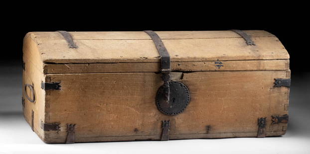
Sold202218th C. Spanish Colonial Mexican Wood & Iron TrunkNorth America, probably Mexico or New Mexico, Spanish Colonial period, ca. late 18th to early 19th century CE. This is a large and well-preserved storage or travel trunk made from wood and wrought iroSee Sold Price
Sold202218th C. Spanish Colonial Animal Hide Petaca**Originally Listed At $600** North America, New Mexico, Spanish Colonial period, ca. late 18th to early 19th century CE. A fine example of a Spanish Colonial petaca (traveling trunk), made of leatherSee Sold Price
Sold202218th C. Mexican Spanish Colonial Steel Knife**Originally Listed At $1000** North America, probably Mexico, Spanish Colonial Period, ca. late 18th to early 19th century CE. A beautiful personal knife with a slender blade and a handle carved fromSee Sold Price
Sold202118th C. American Iron Rushlight Tongs**Originally Listed At $250** North America, United States, ca. late 18th to early 19th century CE. A fine set of rushlight tongs that was used to hold burning lengths of rush pith soaked in fat or grSee Sold Price
Sold2022Group of Six 18th C. Copper-Engraved MapsLot comprised of six 18th century maps: 1) Copper-engraved map, circa 1794, of North America at the end of the 18th century, with the configuration of the northwest coast and Alaska growing ever moreSee Sold Price
Sold2021Lot of 12 Early 19th Century MapsMostly by Jeffery's. Depicting the East Indies, Germany and surround, Asia, Africa, "Turky in Asia" , Italy and surround, Spain & Portugal, early North America, France, South America, Europe, and HungSee Sold Price
Sold2023A Grouping of 17th & 18th Century Old World Maps Lot of 6Lot Includes: The English Channel, A Map of France, North American Rivers and Lakes Between Superior and Slave Lake (2), A New map of Russia in Europe, & Nouvelle Carte Du Royaume de Bengale EngraSee Sold Price
19 hrs LeftLink Auction Galleries[Engraved for Charles Stedman's History of the American War] , Philadephia/ London late 18th c., A$600(2 bids)
BonhamsAFTER OGATA KŌRIN A Small Inlaid-Lacquer Three-Case InrōEdo period (1615-1868), 18th c...$600
May 18Rich Penn AuctionsDecorative Art, map of South America, late 18th C., framed & matted, Exc cond, 24"H x 20"W overall.$50
2 days LeftRalph Fontaine Heritage Auctions Inc.Early Late 18Th C. Early 19Th C. Oil On Canvas Of Boy With Bird Cage$75(2 bids)
2 days LeftRalph Fontaine Heritage Auctions Inc.Extremely Well Done Oil On Panel Of Nanny With Children$50(1 bid)
2 days LeftAustin Auction Gallery(6) DUTCH DELFT BLUE & WHITE TIN-GLAZED SIX-PIECE GARNITURE SET$1,500
2 days LeftAustin Auction Gallery(3) DUTCH DELFT BLUE & WHITE TIN-GLAZE THREE-PIECE GARNITURE SET$300(1 bid)
2 days LeftAustin Auction Gallery(2) LARGE DELFT BLUE & WHITE TIN-GLAZED CHARGERS, 18TH C.$350(1 bid)


![After Michael Mercator: (Dutch, late 16th/early 17th century) Map of the Americas, entitled: [America sive India Nova ad magnae Gerardi Mercatoris aui Uiniversalis imitationem in compendium redacta], 1595-1619, modern facsim](https://p1.liveauctioneers.com/33/131921/67027348_1_x.jpg?height=310&quality=70&version=1543252578)


![[Shelf-Lot, Bindings, Various] (1 of 6)](https://p1.liveauctioneers.com/3532/326332/175680480_1_x.jpg?height=282&quality=70&version=1713150771)

![[Engraved for Charles Stedman's History of the American War] , Philadephia/ London late 18th c., A (1 of 5)](https://p1.liveauctioneers.com/7338/325101/175021408_1_x.jpg?height=282&quality=70&version=1712178426)


