Sold2019Shury, J. C1820 HCol Map of North Sea/German OceanHand Coloured Copper Engraved Map Published C1820, London. Engraved by J. Shury. Paper Size: 11.5 x 9.5 inch (29 x 24cm) Mounted/stuck to modern card. Some toning. Margins slightly trimmed affecting iSee Sold Price
Sold2018North Atlantic Ocean On Mercator's ProjectionTitle/Content of Map: North Atlantic Ocean On Mercator's Projection Date Printed: 1890 Cartographer: BARTHOLOMEW, JOHN & CO. Size (inches): 11.8X16.5 "By J. Bartholomew, F.R.G.S." 57 From Bartholomew'See Sold Price
Sold2017Carte de l'Ocean Occidental DresseeMap: Carte de l'Ocean Occidental Dressee pour Servir a l'Histoire Generale des Voyages, 1746 Maker: J Bellin Date: 1746, Paris Description: This is a fantastic map of the North Atlantic. It is centereSee Sold Price
Sold2018Bartholomew: Antique Map of Atlantic Ocean, 1879Title/Content of Map: Atlantic Ocean &C. Date Printed: 1879 Cartographer: BARTHOLOMEW, J. Size (inches): 10.5X15 Dry."shewing the communication between Europe, North America and the Pacific." Shows unSee Sold Price
Sold20171868-1869 NAVAL MAP OF THE NORTH PACIFIC OCEANMade up of Sheets I, II and III. (18) 13 x 13 inch sheets backed with cloth. 38 1/2 x 79 1/2 inches (to end of margins (overall))See Sold Price
Sold2019Huge/clean 1867 wall map of North America, J. T. LloydHuge antique wall map in rare condition...varnish appears nearly fresh with absolutely no cracking. Includes original rollers which are also in great condition. Great hand-coloring and strong print. TSee Sold Price
Sold20211796 MAP OF NORTH & SOUTH CAROLINA, DENISON, FRAMEJ. Denison (American, 18th century). "Map of North and South Carolina" -1796, from "Morse's Universal Geography", engraving. Framed. Provenance: From the Lifetime Collection of Billy S. Arant, Jr., ChSee Sold Price
Sold2022MAP OF BRITISH & FRENCH SETTLEMENTS IN N. AMERICAby John Hinton London, University Magazine. 1755. 13 x 15 inches Together with a fragment of a second map of North America by J. Hinton. each printed on laid paper and hand colored Condition: Tear toSee Sold Price
Sold20221850 Tallis Map of North America -- North AmericaTitle: 1850 Tallis Map of North America -- North America Cartographer: J Tallis Year/Place: 1850, London Dimensions: 14 x 9.5 in. Description: This is a highly decorative and striking map of North AmeSee Sold Price
Sold2022VANCOUVER, George (1757-1798). A Voyage of Discovery to the North Pacific Ocean and Round the World.VANCOUVER, George (1757-1798). A Voyage of Discovery to the North Pacific Ocean and Round the World. London: G. G. 7 J. Robinson, 1798.   4 volumes, comprising: text, 3 volumes, 4to (295 x 233 mmSee Sold Price
Sold2016Map of North America...David H. Vance, engraved by J.H. Young. Philadelphia: Anthony Finley, 1825. Engraved map in 5 parts with original hand color in outline. 25 7/8 x 20 1/2 inches sheet, 30 5/8 x 25 1/2 inches framed.See Sold Price
Sold2021FRAMED J.H. COLTON MAP OF NORTH AMERICA CA INSETFramed engraving on paper, Map of North America from the Latest Authorities, published by J.H. Colton (Joseph Hutchins Colton, 1800-1893), No. 86 Cedar St., New York, 1846, drawn and engraved by J.M.See Sold Price
Sold2023Seutter - Map of North America including Great Lakes, Florida, Virginia, New England, Mexico, WestThis engraving is from a composite atlas presented by the Homann Heirs. Many of the maps in the collection were completed by J. B. Homann, Homann Erben, M. Seutter, and T. C. Lotter. The maps were oriSee Sold Price
Sold20191792 Elwe Map of North America -- AmeriqueTitle/Content of Map: 1792 Elwe Map of North America -- Amerique Septentrionale Divisee en Ses Principales Parties Cartographer: J ElweDate: 1792, Amsterdam Size: 18.3 X 23.1 in. This is an outstandinSee Sold Price
Sold2017Tallis: Antique Map of North America, 1851Title/Content of Map: 1851 Tallis Map of North America -- North America Date Printed: 1851 London Cartographer: J. Tallis Size: 14 x 9.5 in. Condition: Very good - good, some age toning mostly in margSee Sold Price
Sold2017Palairet / Kitchin: Map of English/French North AmericaMap: Carte des Possessions Angloises & Francoises du Continent de l'Amerique Septentrionale Cartographer: J. Palairet / Kitchin Place & Date: London / 1756 Size: 22 3/4" x 17" Condition: beautifully cSee Sold Price
Sold2020Map No. 1. Reconnaissance and Survey of a Railway RouteTitle/Content of Map: Map No. 1. Reconnaissance and Survey of a Railway Route from Mississippi River Near the 35th Parallel North Lat. to Pacific Ocean Made Under Direction of the Secry. Of War [MissiSee Sold Price
Sold20181639 Janssen Map of East Coast of North America -- NovaTitle/Content of Map: 1639 Janssen Map of East Coast of North America -- Nova Anglia Novum Belgium et Virginia Date: 1639 c. Amsterdam Cartographer: J Janssen Size: 15.3 x 19.7 in. This is an importanSee Sold Price
Sold20231729 Map of New England, New York, Herman Moll1729 English Map of New England, Herman Moll (1654-1732). Map titled, "NEW ENGLAND NEW YORK NEW JERSEY and PENNSYLVANIA". Map with detailed depiction of the North East, with hand coloring. Good conditSee Sold Price
Sold2023An Accurate Map of the English Colonies in North America Bordering on the Ohio Riverfrom Universal Magazine, London, circa 1754, engraving on laid paper with hand colored highlights, sight 7-3/4 x 9-1/2 in.; framed, 12-7/8 x 14-1/2 in. Provenance: Estate of Dr. J. Francis and LaquitaSee Sold Price
Sold2017Keulen: Antique Map of the British Isles, 1678Map: British Isles Date Printed: 1678-1682 Cartographer: J Keulen Material/Medium: Paper Size: 21" x 24" Printed on thick paper. Double page map. Rare map of the British isles with north oriented to tSee Sold Price
Sold20221721 Senex Map of British Caribbean Islands -- A New Map of the English Empire in the Ocean ofTitle: 1721 Senex Map of British Caribbean Islands -- A New Map of the English Empire in the Ocean of America or West Indies Cartographer: J Senex Year/Place: 1721, London Dimensions: 20.1 X 23.8 in.See Sold Price
Sold2021Mackenzie's Voyages 1802 w/ large folding mapHeading: Author: Mackenzie, Sir Alexander Title: Voyages from Montreal on the River St. Laurence through the Continent of North America to the Frozen and Pacific Oceans in the Years 1789 and 1793. WiSee Sold Price
Sold2018Senex: Antique Map Jamaica & British West Indies, 1721Title/Content of Map: A new map of the English Empire in the Ocean of America or West Indies Cartographer: J. Senex Place & Date: London / 1721 Size: 23 3/4" x 20" Condition: full wash color; repairedSee Sold Price
1 day LeftNorth American Artifact Auctions8 Stereoscope Cards - Ships: Columbus Flag Ship, Battleship Indiana 1887-early 1900's$55(2 bids)
May 09Hunt and Peck Estate Services, Inc.1784 Captain James Cook "A Voyage to the Pacific Ocean" 2 of 3 volumes$200(1 bid)
Apr 27Renew GalleryCirca 1815 Engraved Map A Plan of the Grand of the New Townships on the Grand or Ottawa River$100
BonhamsVelvet-upholstered Loveseat and Tray Table, Baker Furniture and L. & J.G. Stickley, North Caroli...$180(4 bids)
BonhamsTufted Leather Chesterfield-style Sofa and Chippendale-style Mahogany Tray Table, Baker Furnitur...$200(1 bid)
3 days LeftSchilb Antiquarian Rare Books1977 JRR Tolkien 1st ed /1st printing Silmarillion Lord of the Rings + MAP$180(7 bids)
3 days LeftSchilb Antiquarian Rare Books1977 JRR Tolkien 1st Silmarillion Lord of the Rings Middle Earth + MAP DJ$74(4 bids)
May 12Schilb Antiquarian Rare Books1977 JRR Tolkien 1st ed 1st Printing Silmarillion Lord of the Rings + MAP + DJ$190(4 bids)
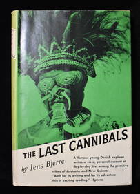
1 day LeftNorth American Artifact AuctionsTHE LAST CANNIBALS by JENS BJERRE 1957 Fine or Near Fine$10(1 bid)


![CHATELAIN, HENRI. 1684-1743. Carte De La Nouvelle France.... [Amsterdam: 1719.] (1 of 3)](https://p1.liveauctioneers.com/1043/324005/175444939_1_x.jpg?height=282&quality=70&version=1713467946)