Sold2021Robert Motherwell - Art Chicago (No Text) - 1981"Art Chicago (No Text)" by Robert Motherwell, 1981 Unsigned Lithograph. Paper size is 27 x 20 inches, with an image size of 23 x 15 inches. The Lithograph is from an edition size of 2000 and is not frSee Sold Price
Sold2019African Maps, text & plates by Klemp, EgonAfrican Maps, text & plates by Klemp, Egon. Africa on Maps dating from the Twelfth to the Eighteenth Century. Year 1968, 4to, wrps. Text in pocket of large cloth folio.See Sold Price
Sold20221875 Map + Text of New Orleans Flood ControlPost Civil War 1875 Map & Description of Flood Control In New Orleans 1875-Dated, Map and Description titled, "The Topography and Drainage of New Orleans" by Thomas S. Hardee, City Surveyor, Choice ExSee Sold Price
Sold2020Guide to Mother Lode with map & text 1939Heading: (California - Mother Lode) Author: Ramsey, R. S. Title: Guide through the Old Mining Regions of Central California Place Published: No place Publisher: Date Published: 1939 DeSee Sold Price
Sold2017Wilkinson: Antique Text Map of Empires of World, 18141814 Map/Text Map of Empires of the World by Wilkinson. Fascinating and unusual chart/map showing the great empires and nations in man’s history. Vertical sections depict each century starting beforSee Sold Price
Sold20241842 VOYAGES OF CAPTAIN JAMES COOK 2 VOLUMES antique ILLUSTRATEDThe Voyages of Captain James Cook London: William Smith, 1842 2 volumes Size 7 by 9 3/4" Additional engraved title in volume I, engraved frontispieces, double-page maps, in-text vignettes, etc. MinorSee Sold Price
Sold20171874 Hand Drawn Book of Maps1874 Hand Drawn Book of Maps Albany NY work book with 44 hand drawn maps and text by John Bell, 1874. Cover is use worn, otherwise VGC. Book is 7" x 8 1/2" Shipping: Domestic: Flat-rate of $15.00See Sold Price
Sold2016[Confederate Imprint] Stewart's Geography[Confederate Imprint]: Stewart, K.J., Rev.: A GEOGRAPHY FOR BEGINNERS. Richmond, Va: 1864. viii, 223 pp. plus 10 folding maps (some other maps in-text). Publisher's cloth, some fading, cloth water-staSee Sold Price
Sold2021Boating maps, Powell Point to rock sound, EleutheraMaps from 1981 tropic Isle publishers, Inc By Harry Kline, Powell point to rock sound, Eleuthera island, Spanish wells and ridley head channel. Size 11“ x 17“See Sold Price
Sold2023"Throwing Blades of Central Africa" book by Marc L. Kipinga, 1991208 pp.; 97 duotone illustrations, two maps in the text, 1 two-colour foldout map, bibliography. Text: German & English. München, 1991. Perfect condition, cloth, in slipcase. KEYWORDS: 010 Africa:See Sold Price
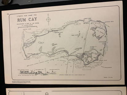
Sold2021Boating maps, rum cay, conception island, San Salvador.Maps from 1981 tropic Isle publishers, Inc By Harry Kline, Rum Cay, Conception island, San Salvador. Size 11“ x 17“See Sold Price
Sold2021Boating maps, Spanish wells to Harbor Island, cays toMaps from 1981 tropic Isle publishers, Inc By Harry Kline, Spanish wells to Harbor Island, cays to Eleuthera, current cut and current settlement. Size 11“ x 17“See Sold Price
Sold2021Boating Maps, central Bahamas, farmers cay galliot cutMaps from 1981 tropic Isle publishers, Inc by Harry Klein, Central Bahamas, farmers Cay galliot cut, size 11“ x 17“See Sold Price
Sold2022Doppelgangers The Truth About the Bodies in the Berlin Bunker.FIRST EDITION. Pictorial dust-jacket with title. Publishers black cloth with gilt title to spine. Full-page illustrations. In-text maps. Uses material previously unavailable from Soviet archives and dSee Sold Price
Sold2021Boating Maps, Brock cay to channel cay, bitter guanaMaps from 1981 tropic Isle publishers, Inc, by Harry Kline, Brock Cay to Channel Cay, Bitter Guana Cay to Brock Cay, Bimini Cat Cay. size, 11“ x 17“See Sold Price
Sold2021Boating maps, Southern Berry islands, Central BerryMaps from 1981 tropic Isle publishers, Inc By Harry Kline, Southern Berry Islands, Central Berry islands, Northern Berry islands. Size 11“ x 17“See Sold Price
Sold2021Boating Maps, Bahamas for out islands, The BahamaMaps from 1981 tropic Isle publishers, Inc By Harry Klein, Bahamas far out islands, The Bahama Islands, airstrip locations.See Sold Price
Sold2021Boating maps, The brights of intros, Stafford Creek toMaps from 1981 tropic Isle publishers, Inc By Harry Kline, The brights of andros, Stafford Creek to North bright, jousters cays to Stanford creek. Size 11“ x 17“See Sold Price
Sold2022Baedeker's Central Italy and RomeFIRST EDITION. Publishers red cloth cover. Gilt title to cover and spine. Large fold-out maps. In-text plans and street maps 14 page section with fold-out maps "Index of Streets and Plans of Rome". MaSee Sold Price
Sold2022Belgian CongoFIRST EDITION. Full-leather with blind-stamped borders. Morocco gilt title, raised bands to spine. Full-page illustrations and maps. In-text illustrations. BOOKLET NO. 41: Mailboat Services from EuropSee Sold Price
Sold2021The Country Houses of England 1948 - 1998First edition. Pictorial dust-jacket with title. Publishers navy cloth with silver title to spine. Full-page colour + b &w illustrations and maps. In-text illustrations. This book explores the survivaSee Sold Price
Sold2021Boating maps, Allen’s Highborne, The Bahamas,Maps from 1981 tropic Isle publishers, Inc By Harry Kline, Allen’s highborn, The Bahamas, South Bright to hawksbill Creek, size 11“ x 17“See Sold Price
Sold2021Boating maps, Nassau Harbour, New Providence Island,Maps from 1981 tropic Isle publishers, Inc By Harry Kline, Nassau Harbour, new Providence Island, Little Harbor and alder cay anchorages. Size 11“ x 17“See Sold Price
Sold2021Boating maps, governors HBR, hatchet bay, northMaps from 1981 tropic Isle publishers, Inc By Harry Kline, governors HPR, hatchet bay, north EleutheraSee Sold Price
May 16Zikorn Arts & History ObjectsJohn J. Pershing, Signed: My Experiences in the World War 1931$300
24 hrs LeftForum AuctionsWorld.- Underwood & Underwood The Grand Canyon of Arizona through the Stereoscope, 18 mounted£50
7 days LeftAdam's AuctioneersH.C CAREY AND I.LEA (publishers) A Complete Historical, Chronological and Geographical AMERICAN€1,500
Featured13 hrs LeftJasper52Underground Map of London. Tube network. Print code 419-25000-3/4/24. April 1924$900
13 hrs LeftJasper52Underground Map of London. Tube network. No print code. June-August/mid 1924$1,100


![[Confederate Imprint] Stewart's Geography: [Confederate Imprint]: Stewart, K.J., Rev.: A GEOGRAPHY FOR BEGINNERS. Richmond, Va: 1864. viii, 223 pp. plus 10 folding maps (some other maps in-text). Publisher's cloth, some fading, cloth water-sta](https://p1.liveauctioneers.com/3532/91776/46880406_1_x.jpg?height=310&quality=70&version=1469669287)


![[MAP - TOURS] (1 of 1)](https://p1.liveauctioneers.com/292/326828/175962850_1_x.jpg?height=282&quality=70&version=1713473479)


