Sold2024Group of Ten Railroad Photographs, Maps, and Prints - New Jersey, Long Island, and New YorkGroup of Ten Railroad Photographs, Maps, and Prints - New Jersey, Long Island, and New YorkA mixed group of framed items for railroads in the New Jersey and New York area. Photographs include people oSee Sold Price
Sold20191832 Marshall Revolutionary War Map of Northern NewTitle/Content of Map: 1832 Marshall Revolutionary War Map of Northern New Jersey -- Plan of the Northern Part of New Jersey Shewing the Positions of the American & British Armies after Crossing the NoSee Sold Price
Sold2022Bowle's New Pocket Map of the Land of CanaanPrinted for the Proprietor Carington Bowles, London. Together with a map of New Jersey and a wood block print of Sir Ralph Verney, Albury, Herts, 1547, 3 pieces total Overall: 23-1/2"h x 27-3/4"w, 29-See Sold Price
Sold20202 Dick LaBonte PrintsDick LaBonte (New Jersey, b. 1921) pair of signed and dated prints, "At the Garden of Allah," 1992 and "When Airships Sailed the Sky," 1988. Overall with frame 20 1/4" to 24 3/4" high x 24 3/4" to 32See Sold Price
Sold2023Assorted Antique Prints of New JerseyAssorted antique prints, engravings, etchings, and other medias of NEW JERSEY, including scenic landscapes, vintage maps, notable cities/towns and landmarks, assorted Harper's Weekly illustrations andSee Sold Price
Sold2021A 1687 Map of Pennsylvania and New JerseyRobert Morden, London, published by Modern and Cockerill in 1687. From the "Atlas Terrestris". Purchased from the Philadelphia Print Shop. Dimensions: Sight is 5 3/4" x 4 3/4", the frame 12 1/4" x 11See Sold Price
Sold2023Assorted Antique Maps of New York & New JerseyAn assortment of antique maps of New York State and New Jersey, together with other prints and engravings depicting American states, cities, and landmarks. Approximately 50 pieces. As is, as shown. PrSee Sold Price
Sold2022Pr of Bergma Elvis Presley Military Gelatin PrintsPair of signed Norman E Bergsma gelatin silver prints of Elvis Presley. From a New Jersey estate. Dimensions: site of larger print measures approx. 18.5" h x 14.75" w, its frame measures approx. 26" hSee Sold Price
Sold2019Revolutionary War Map"A Plan of the Operations ... in New York and East New Jersey against the American Forces Commanded by General Washington" 29" x 20" (sight) Claude Joseph Sauthier, 1777See Sold Price
Sold2023Stedman's edition of Faden's plan of the Battle of New York[MAP-AMERICAN REVOLUTION] STEDMAN, CHARLES and FADEN, WILLIAM. A Plan of the Operations of the King's Army under the Command of General Sr. William Howe, K.B. in New York and East New Jersey against tSee Sold Price
Sold2017Pair of George &Martha Washington Portrait PrintsTogether with a portrait engraving of a gentleman. 4"h x 2 1/2"w. Provenance: Property of a New Jersey Collector.See Sold Price
Sold2021Chikanobu (1838 - 1912) Two Woodblock PrintsA pair of prints, each with some text in English, one depicts the figures in western dress. Dimensions: Sight for each is 13" x 9 1/4", the frames are 20" x 15 1/2". Provenance: From a New Jersey collSee Sold Price
Sold2019New York Antique Maps (2)Plan of City of New York by Lyne, c. 1900. Map of Provinces of New York and New Jersey by Sauthier, 1878 edition. 26" x 19 1/2".See Sold Price
Sold2023Map of a Part of New Jersey, Penn. & Delaware.Publication Date: 1806 Title: Map of a Part of New Jersey, Penn. & Delaware. Cartographer: YEAGER, J. ? Publisher: C.P. WAYNE Height: 6 Width: 3.5 "XIII" First Edition (First Issue?) Plan from MarshalSee Sold Price
Sold2021Pair of 19th century maps of PennsylvaniaPair of 19th century maps of Pennsylvania: North America Sheet VII, Pennsylvania, New Jersey... And Part of Virginia, c.1833, hand colored, 16 x 14 inches //AND// Map of Pennsylvania Prepared ExpresslSee Sold Price
Sold2023Good, Peter 1847 Pair of Hand Col Botanical Prints. Rose & CarnationHand Colored Lithographs Published 1847, Elizabethtown, New Jersey for "The Family Flora and Materia Medica Botanica" by Peter P. Good. Paper Size: 9 x 6 inch (23 x 15cm) Minor background toning, otheSee Sold Price
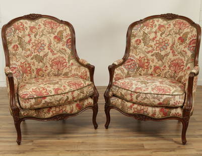
Sold2022Pair of Louis XV Style Beechwood BergeresPair of Louis XV Style Beechwood Bergeres upholstered in foliate print. 43.25" H x 32.5" W x 36" D Property from a Fine Collection of Antiques & Decorative Art, Rumson, New Jersey.See Sold Price
Sold2022Pair 19th C Framed Color Maps, Louisiana & New OrleansPair of 19th C Framed Color Maps, Louisiana & New Orleans. A set of framed maps; a state map of Louisiana from 1848 and a city plan of New Orleans from 1884. Both are published by S. Augustus MitchellSee Sold Price
Sold2016Map of New York Bay. North America. 1839.Print of steel engraving titled „Plan de la baie de New-York“.Drawn by unknown.Engraved by Blondeau.From „Etats-Unis D‘Amerique by M. Roux de Rochelle. Published by Firmin didot freres. Paris.See Sold Price
Sold2018Pair Antique 19th Century Atlases, Bound MapsPair Antique 19th Century Atlases. ‘Mitchell’s New General Atlas Containing Maps of Various Countries of the World, Plans of Cities, Etc.’ published by S. Augustus Mitchell, Jr. c 1860. ‘AtlasSee Sold Price
Sold2018Pair Antique 19th Century Atlases, Bound MapsPair Antique 19th Century Atlases. ‘Mitchell’s New General Atlas Containing Maps of Various Countries of the World, Plans of Cities, Etc.’ published by S. Augustus Mitchell, Jr. c 1860. ‘AtlasSee Sold Price
Sold2020Plan of New York, Mitchell 1860New York City with Green Point, Williamsburg, Brooklyn, Jersey City and Hoboken all labeled clearly. Original hand coloring. Collectible map with some faults so low reserve. From the 1864 Mitchell NewSee Sold Price
Sold2022New road map of the city of Paris 1839 Rosselin editeur engravingNouveau plan routier de la ville de Paris, Guide exacte de cette capitale : en 12 arrondissemens avec leurs mairies et en 48 quartiers, 1839V. ROSSELIN (19th century), print editor, Paris, EstablishedSee Sold Price
Sold2022Kelly, Christopher 1816 Pair of Prints. AfricaView in Sierra Leone and Hottentots Trying a Criminal. Copper Plate Published 1816, London for "A New and Complete System of Universal Geography" by Christopher Kelly. Maps Engraved by Findlay, WallisSee Sold Price
5 days LeftJasper52A New and accurate Map of New Jersey… Universal Magazine 1780 old antique$650
5 days LeftJasper52NEW YORK CITY antique town city map plan. Manhattan Brooklyn Jersey. SDUK 1844$550
5 days LeftJasper52A plan of the operations of the King's army… in New York… FADEN/STEDMAN 1794 map$6,500
22 hrs LeftTrillium Antique Prints & Rare BooksAudubon - Pair of Lithographs of Northern Hare$25(1 bid)
2 days LeftRobinhood AuctionsCharles Fazzino- 3D Construction Silkscreen Serigraph "There's Music: New Jersey, New York, Long$1,100
22 hrs LeftTrillium Antique Prints & Rare BooksDuhamel, Poiteau, & Turpin - Pair of Grape Engravings$300
6 days LeftRobinhood AuctionsCharles Fazzino- 3D Construction Silkscreen Serigraph "There's Music: New Jersey, New York, Long$1,100
May 05Tremont Auctions18th century map of New Jersey. "A New and Accurate Map of New Jersey". W. Long, London. Map size 13$100
4 days LeftJasper521866 Johnson Map of Pennsylvania and New Jersey -- Johnson's Pennsylvania and New Jersey$40
5 days LeftJasper52The country round Philadelphia. New Jersey Pennsylvania NY. GENTS MAG 1776 map$300
5 days LeftJasper52Bahamas. Turks & Caicos. New Providence. Nassau plan. 53x67cm. STANFORD 1896 map$360
2 days LeftRapid Estate Liquidators and Auction GalleryNew Jersey & Delaware Porcelain Souvenir Plates$5


![Stedman's edition of Faden's plan of the Battle of New York: [MAP-AMERICAN REVOLUTION] STEDMAN, CHARLES and FADEN, WILLIAM. A Plan of the Operations of the King's Army under the Command of General Sr. William Howe, K.B. in New York and East New Jersey against t](https://p1.liveauctioneers.com/292/307340/164259694_1_x.jpg?height=310&quality=70&version=1698409460)