Sold20201853 U. S. map w/large Texas, Daniel BurgessDelightful early school atlas map of this region. Shows counties, parishes, towns, rivers, populations, Indian Tribes, Court Houses, Forts and many other details. Includes several steamships and notesSee Sold Price
2017Burgess: Antique Map of the United States, 18531853 Map of the United States with large Texas. Daniel Burgess. Delightful early school atlas map of the region. Shows counties, parishes, towns, rivers, populations, Indian Tribes, Court Houses, FortSee Sold Price
Sold2022Scarce 1844 U. S. map w/large Texas, western territoriesOne of the more interesting and elusive school maps of the United States at a time of great territorial expansion. This 1844 double-page Olney school geography map shows the Republic of Texas in one oSee Sold Price
Sold2017Fascinating 1853 Map of Western StatesFascinating 1853 map of Western States. Daniel Burgess. Early, interesting configuration of the West prior to the inclusion of Colorado, Idaho, Wyoming, Montana, Nevada and Arizona. New Mexico TerritoSee Sold Price
Sold2019Two Antique MapsTwo Antique Maps. Map of United States and Texas, dated 1839 by Daniel Burgess and a Map of Mexico Central America and the West Indies, dated 1867 by S Augustus Mitchell.See Sold Price
Sold2018U.S. Coast Survey 1853 Map of Aransas Pass, Texas"Reconnoissance of Aransas Pass Texas" Electrotype Map Published 1843-65, Washington for "Report of the Superintendent of the U.S. Coast Survey..." Published under the supervision and direction of AleSee Sold Price
Sold2018U.S. Coast Survey 1853 Map of Galveston Entrace, Texas"(Sketch I No. 3) Galveston Entrance Texas" Electrotype Map Published 1843-65, Washington for "Report of the Superintendent of the U.S. Coast Survey..." Published under the supervision and direction oSee Sold Price
Sold20191853 No. 4 United States, BurgessInteresting map of the Atlantic states from Mitchell’s 1853 School Atlas published by Thomas, Cowperthwait & Co. The map is copyrighted by Daniel Burgess. In this map West Virginia is still part ofSee Sold Price
Sold2017Burgess: Antique Map of the United States & Canada 1853Map of the United States and Canada, Burgess 1853. Great map of the U. S. during the transitional period of the American West. Most of the western lands are shown as large territories: Minnesota, NebrSee Sold Price
Sold2024Map of California, Utah, Oregon,New Mexico 1853Map of California, Utah, Oregon,New Mexico, Washington and Nebraska Hand colored. Map No 10 United States Cartographer: Jules Sherman Smith Publisher Daniel Burgess Dated: 1853<See Sold Price
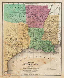
Sold20211847 map showing east Texas/Indian TerritoryInteresting map of the southern U. S. in 1847. Map by Cady & Burgess from Roswell SmithÂ’s 1847 Quarto Atlas. Eastern portion of Texas shown along with most of Indian Territory. Also includes ArkanSee Sold Price
Sold2021Early U.S. map shows Texas, Upper Calif. – 1839Title: Early U.S. map shows Texas, Upper Calif. – 1839 Description: Vintage and interesting geography map showing Texas and Upper California at a time when they made up the entire southwestern UniteSee Sold Price
Sold2017US Survey: Antique Map of Florida, 1853Map: 1853 US Survey Map of Florida -- A Plat Exhibiting the State of the Surveys in the State of Florida Date Printed: 1853, Washington Cartographer: US State Surveys Size: 22 x 24.8 in. Condition: GoSee Sold Price
Sold20231853 U.S. Coast Survey Map of New Orleans1853 U.S. Coast Survey Map of New Orleans, Lake Pontchartrain and the Mississippi Delta hand-colored lithograph, inscribed "U.S. Coast Survey, A. D. Bache Superintendent, Sketch H, Showing the progresSee Sold Price
Sold2021Scarce 1853 Texas map by Roswell SmithAntique and hard to find antebellum map with full original hand coloring. Engraving on paper. Shows forts, rivers, locations of tribes, towns, counties and topographical features. Eastern Indian TerriSee Sold Price
Sold2017Daniel Burgess: Map of United States & Canada, 1846Map of the United States and Canada. Daniel Burgess, c1846. Drawn and engraved by Stiles, Sherman & Smith. 10.5 x 17.5 inches. Three tiny holes in center fold from publisher’s binding strings. 5”See Sold Price
Sold2020With U.S. map showing "maximum" TexasHeading: (Atlas) Author: Olney, J. Title: Olney's School Atlas Place Published: New York Publisher:Pratt, Woodford & Co. Date Published: 1844 Description: With 16 hand-colored coSee Sold Price
Sold2023Burgess & Cain 1853 Map #7 OH, IN, KY, TNTitle: Burgess & Cain 1853 Map #7 OH, IN, KY, TN Dimension: 11 ½” x 9 ½” Provenance:A beautiful colored map of what were the northern middle states in 1853. It shows all the majoSee Sold Price
Sold2017Burgess: Map of North America, 1839/1848Map of North America, Daniel Burgess 1839/1848. 8.5 x 10.75 inches. From Smith’s Geography for Schools. Striking engraved map with full original hand-coloring. Although map is dated 1839, it came frSee Sold Price
Sold2023Scarce 1855 map of U.S. w/large territorial bordersScarce and collectible 1855 example of Cowperthwait, Desilver & Butler map of the U.S., at a time when the west was experiencing some of its most unusual US territorial configurations. Oregon TerritorSee Sold Price
Sold2018LaPie / Tardieu: Antique Map of US, Texas, Mexico, 1809Map: Mexique Cartographer: P. LaPie / Tardieu Place & Date: Paris / 1809/1812 Size: 11 7/8" x 8 3/4" Condition: outline color; light overall age toning, otherwise beautifully preserved A detailed mapSee Sold Price
Sold2023ANTIQUE FLORIDA FRAMED MAPS - LOT OF 2148268 ANTIQUE FLORIDA FRAMED MAPS - LOT OF 2 Antique Florida map framed map to include one 1853 U.S. Coast Survey Chart or Map of St. George's Sound, Florida, and one unsigned map of Florida denotedSee Sold Price
Sold2022Map No. 7. United StatesTitle: Map No. 7. United States Publication Date: 1854 Title: Map No. 7. United States Publisher: Daniel Burgess & Co. Height: 10.5 Width: 8.5 From Roswell C. Smith's Geography. Shows IN, OH, KY, TN aSee Sold Price
Sold20211864 American History INDIANS Mexico TEXAS Revolution1864 American History INDIANS Mexico TEXAS Revolutionary War US Map Willson Marcus Willson’s “American History” is a mid-19th-century compendium of the history of the United States from its earlSee Sold Price
5 days LeftJasper52U.S. War Department. Map of the Yellowstone and Missouri Rivers and Their Tributaries.$240
1 day LeftAlexander Historical Auctions LLCKAPITANLEUTNANT WALTHER SCHWIEGER COMMEMORATIVE PLAQUE$100
2 days LeftMatthew Bullock AuctioneersU.S. Speaker of the U.S. House of Representatives, Massachusetts Congressman, U.S. Senatorfrom$170
1 day LeftAlexander Historical Auctions LLCBATTLE OF ST. MIHIEL BATTLE MAP, USED BY COL. WILLIAM J. DONOVAN$200(1 bid)