Sold2021Map of the Polar Regions - Arctic DiscoveriesMap of the Polar Regions Showing Recent Discoveries With Mercator Map of the Eastern Hemisphere on verso Cartographer: George Franklin Cram Dated: Circa 1900See Sold Price
Sold2015AFTER GERARD VALCK MAP 1827AFTER GERARD VALCK (1651-1726), MAP, 1827, 17'' X 21'', MAPPE MONDE GEO HYDROGRAPHIQUE DU GLOBE, NOT FRAMED:Engraved, hand colored map showing the southern polar region, northern polar regions, and twSee Sold Price
Sold2024The Physical Geography of the Sea[Map/Atlases] Maury, Matthew Fontaine. The Physical Geography of the Sea. Harper & Brothers, Publishers. New York. 1855. 8vo, xx 474 (xvi single page and folding plates) (1) (24 ads) pp., original embSee Sold Price
Sold2019Map of North America. Showing Its Political Divisions,Reserve Reduced! Title: Map of North America. Showing Its Political Divisions, and Recent Discoveries in the Polar Regions. Publication Date: 1861 Cartographer: WILLIAMS, W. Publisher: S. Augustus MitSee Sold Price
Sold20231850 OREGON & CALIFORNIA EXPLORING EXPEDITION by J. FREMONT GOLD REGION antiqueOREGON AND CALIFORNIA: THE EXPLORING EXPEDITION TO THE ROCKY MOUNTAINS, OREGON AND CALIFORNIA. TO WHICH IS ADDED A DESCRIPTION OF THE PHYSICAL GEOGRAPHY OF CALIFORNIA by Col. J.C. Fremont, Brevet BuffSee Sold Price
Sold20161890 Warren's New Physical Geography“Warren’s New Physical Geography”, printed by E H Butler, 1890. Philadelphia. Numerous lithograph maps. 142 pages followed by index. Worn original covers, internally very good, measures 10.5 x 1See Sold Price
Sold2023Group of Antique Polar Maps (4)Four Antique maps relating to the polar regions. The World in Three Sections, Alexander Hogg. North Pole, Emanuel Bowen. North Pole from Carey's Edition of Guthrie's Geography Improved. Polus ArcticusSee Sold Price
Sold2017Mitchell: Antique Map of North America, 1860Map of North America Showing Its Political Divisions and Recent Discoveries in the Polar Regions. This is the 1860 pre-Civil War plate, but was published in 1866 by Mitchell in his New General Atlas.See Sold Price
Sold2022Antique Civil War Era Map of North American by by S. Augustus Mitchell, Jr., 1860Antique Civil War Era Map of North American by by S. Augustus Mitchell, Jr., 1860 | Full Title: Map of North America Showing Its Political Divisions, and Recent Discoveries in the Polar Regions | ConsSee Sold Price
Sold2018Mallet: Antique Map of Iberia, Spain & Portugal, 1683Title of the Map: 'Espagne Moderne' IBERIA. Spain & Portugal showing regions. Date Printed: 1683 Image Size: Approx Overall page size 13 x 21cm approximately (5 x 8 inches); image size 10.5 x 14.5cm aSee Sold Price
Sold2019Goldsmith, Rev. J 1842 Astronomy Globe Prints (3)One is the Title Page, showing a globe. Steel Engravings Published 1842, London for "Goldsmith's Grammar of Geography" by W. S. Kenny and the Rev. Goldsmith. Folds as issued. Paper Size: 5.5 x 3.5 incSee Sold Price
Sold2017Map of North AmericaMap of North America Showing Its Political Divisions, and Recent Discoveries in the Polar Regions by S. Augustus Mitchell Jr. 1877 Size: 11.5 x 15.25 in No Reserve: This lot starts at $1 and has no reSee Sold Price
Sold2020Map of N. America, Mitchell 1860Great Mitchell “Map of North America Showing its Political Divisions and Recent Discoveries in the Polar Region.” This map came from Mitchell’s 1862 New General Atlas. Full vintage hand coloringSee Sold Price
Sold20221852 Map of U. S. w/transitional western regionsSignificant double-page map showing transitional western borders including the important territorial acquisitions of the Mexican-American War, pre-Gadsden Purchase. The inset map "No. 6 Map of the GolSee Sold Price
Sold20181852 Map of U. S. w/transitional western regionsReserve Reduced! Significant double-page map showing transitional western borders including the important territorial acquisitions of the Mexican-American War, pre-Gadsden Purchase. The inset map "No.See Sold Price
Sold20241874 POLAR & TROPICAL WORLDS by HARTWIG antiquePOLAR & TROPICAL WORLDS A Description of Man and Nature in the Polar and Equatorial Regions of the Globe by Dr. G. HARTWIG Published by J.W. Lyon, Guelph, Ont.; 1874 2 volumes in one 811 pages, illustSee Sold Price
Sold2022Polar.- Fullarton (Archibald) & Co. Arctic Regions,Polar.- Fullarton & Co. (Archibald) Arctic Regions, map of the Arctic showing the Northwest Passage discovered by the Irish Captain Robert McClure in 1850-53, with inset map above of the Wellington ChSee Sold Price
Sold2019Scarce 1850 plants distributionScarce 1850 map or chart by Joseph Meyer depicting plant geography. Shows the distribution of vegetation throughout the world. Features five illustrations showing the vegetation in various regions, inSee Sold Price
Sold2022TIN DIE CUT POLAR TOBACCO AD.Beautiful graphics, strong color and great gloss showing polar bear standing on glacier marked "Polar Chewing & Smoking Tobacco" with logo "Always The Best" carved into the glacier. Bottom right handSee Sold Price
Sold2022ELIZABETH II; QUEEN OF THE UK; AND PHILIP; DUKE OFELIZABETH II; QUEEN OF THE UK; AND PHILIP; DUKE OF EDINBURGH. Christmas card Signed by both, "Elizabeth R" and "Philip," including reproduction of a photograph on an inside page showing half-length poSee Sold Price
Sold2021Crimee [Crimea]. URSS, 1930s. Soviet-era lithographCrimee [Crimea]. URSS, 1930s. Soviet-era lithograph Intourist railways poster to the Crimean peninsula, showing the region’s famous Swallow’s Nest architecture. 38 ½ x 26 1/8”.See Sold Price
Sold2022China.- Speed (John) The Kingdome of China newly augmented, 1626.China.- Speed (John) The Kingdome of China newly augmented, the only carte-a-figures map made of the region, showing China, Korea and Japan, with 8 costumed figures along the left and right borders, aSee Sold Price
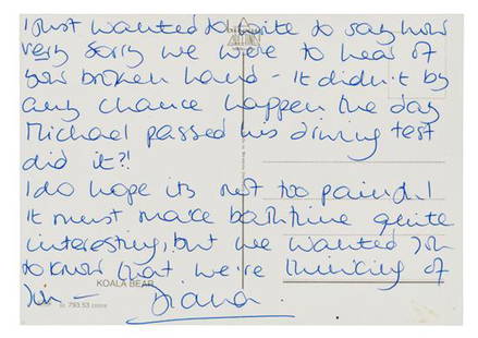
Sold2018DIANA, Princess of Wales (1961-1997).* DIANA, Princess of Wales (1961-1997). Autograph letter signed ("Diana"), to an unnamed recipient. N.p., n.d. 1 page, 12mo postcard showing a koala bear. In full: "I just wanted to write to say how vSee Sold Price
Sold2019Arrowsmith's London atlas of the world, 1838Heading: Author: Arrowsmith, John Title: The London Atlas of Universal Geography, Exhibiting the Physical & Political Divisions of the Various Countries of the World, Constructed from Original MateriSee Sold Price
16 hrs LeftJasper52Scarce 1st ed. map of the world from Moll’s System of Geography, 1701$40(2 bids)
May 09Rail & Road AuctionsSix Ontario Northland Railroad Dining Car Menus - Aqumik, Cochrane Restaurant Polar Bear, and More$50
Featured16 hrs LeftJasper521st ed. of Moll’s fascinating 1701 map of Isle of California$160(3 bids)
May 04BucklinDando, Walter; Wild Animals and the Camera [1909 1ST EDITION - Peter Beard interest]$50(1 bid)
1 day LeftAlexander Historical Auctions LLC101ST AIRBORNE 506TH PARACHUTE INFANTRY ‘CURRAHEE SCRAPBOOK’ SIGNED BY FOUR MEMBERS$140
May 04Bucklin[SIGNED] Lewis, Samella S.; Waddy, Ruth G.; Black Artists on Art Volume 1 [RARE 1971 1ST HARDCOVER]$150
May 04BucklinClark, Larry; LOS ANGELES 2003-2006 [SIGNED - 2006 1ST EDITION HARDCOVER - FINE COPY]$120(1 bid)
May 04BucklinEvans, Walker; Many Are Called [1966 1ST EDITION HARDCOVER WITH DUST JACKET- NICE COPY]$50
May 04BucklinVarious; Invisible Weapon [RARE US WAR DEPARTMENT PAMPHLET NO. 20-13 WWII PROPAGANDA]$50(1 bid)
May 04BucklinAndo, Tadao [SIGNED]; TADAO ANDO COMPLETE WORKS 1975-2012 [W/ ORIGINAL CHURCH OF LIGHT DRAWING]$100


![The Physical Geography of the Sea: [Map/Atlases] Maury, Matthew Fontaine. The Physical Geography of the Sea. Harper & Brothers, Publishers. New York. 1855. 8vo, xx 474 (xvi single page and folding plates) (1) (24 ads) pp., original emb](https://p1.liveauctioneers.com/179/322586/173446725_1_x.jpg?height=310&quality=70&version=1710432851)


![Crimee [Crimea]. URSS, 1930s. Soviet-era lithograph: Crimee [Crimea]. URSS, 1930s. Soviet-era lithograph Intourist railways poster to the Crimean peninsula, showing the region’s famous Swallow’s Nest architecture. 38 ½ x 26 1/8”.](https://p1.liveauctioneers.com/928/200564/101543285_1_x.jpg?height=310&quality=70&version=1618323144)


![Dando, Walter; Wild Animals and the Camera [1909 1ST EDITION - Peter Beard interest] (1 of 9)](https://p1.liveauctioneers.com/8658/325945/175541717_1_x.jpg?height=282&quality=70&version=1712964944)


![Thiebaud, Wayne [SIGNED]; Recent Works By Wayne Thiebaud (1 of 5)](https://p1.liveauctioneers.com/8658/325945/175541767_1_x.jpg?height=282&quality=70&version=1712964944)
![[SIGNED] Lewis, Samella S.; Waddy, Ruth G.; Black Artists on Art Volume 1 [RARE 1971 1ST HARDCOVER] (1 of 11)](https://p1.liveauctioneers.com/8658/325945/175541857_1_x.jpg?height=282&quality=70&version=1712964944)
![Clark, Larry; LOS ANGELES 2003-2006 [SIGNED - 2006 1ST EDITION HARDCOVER - FINE COPY] (1 of 10)](https://p1.liveauctioneers.com/8658/325945/175541298_1_x.jpg?height=282&quality=70&version=1712964944)
![Evans, Walker; Many Are Called [1966 1ST EDITION HARDCOVER WITH DUST JACKET- NICE COPY] (1 of 12)](https://p1.liveauctioneers.com/8658/325945/175539793_1_x.jpg?height=282&quality=70&version=1712964944)
![Rock, Mick; The Rise of David Bowie 1972-1973 [SIGNED COPY] (1 of 7)](https://p1.liveauctioneers.com/8658/325945/175541886_1_x.jpg?height=282&quality=70&version=1712964944)


![Various; Invisible Weapon [RARE US WAR DEPARTMENT PAMPHLET NO. 20-13 WWII PROPAGANDA] (1 of 7)](https://p1.liveauctioneers.com/8658/325945/175540880_1_x.jpg?height=282&quality=70&version=1712964944)
![Ando, Tadao [SIGNED]; TADAO ANDO COMPLETE WORKS 1975-2012 [W/ ORIGINAL CHURCH OF LIGHT DRAWING] (1 of 8)](https://p1.liveauctioneers.com/8658/325945/175541704_1_x.jpg?height=282&quality=70&version=1712964944)