Sold20211950 Feher Pictorial Map of Hawaiian Islands for DoleTitle: 1950 Feher Pictorial Map of Hawaiian Islands for Dole Pineapples -- The Dole Map of the Hawaiian Islands Cartographer: J Feher Year / Place: 1950, Honolulu Map Dimension (in.): 18.8 X 28 in. ThSee Sold Price
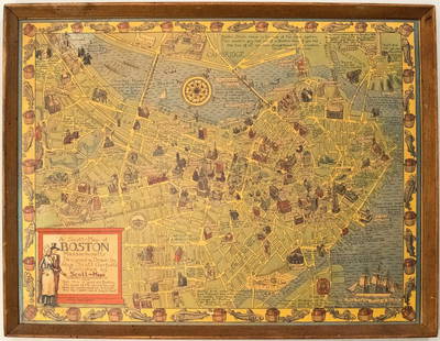
Sold20191950s Garfield Pictorial Map of Boston -- A Scott-MapTitle: 1950s Garfield Pictorial Map of Boston -- A Scott-Map of Boston Massachusetts Date: ca. 1950, Concord, MA Cartographer: A Scott Garfield Size: 20.7 x 27 in. Additional Information: A very attraSee Sold Price
Sold20211950 Putnam Pictorial Map of Southern California --Title: 1950 Putnam Pictorial Map of Southern California -- Ride the Roads to Romance along the Gold Coast thru the Sunshine Empire of Southern California Cartographer: C Putnam Year / Place: 1950, SanSee Sold Price
Sold2023LINDGREN, Hjalmer “Jolly” (1895–1952). A Hysterical Map of ...LINDGREN, Hjalmer “Jolly” (1895–1952). A Hysterical Map of Lake Tahoe and Woolly Nevada with Its Open Places. 1947. Spokane, WA: Lindgren Bros. Color pictorial map of the Lake TahoeSee Sold Price
Sold2022(PICTORIAL MAPS.) D.E. Bates. Cunard R.M.S. Caronia / Great African Cruise 1950.(PICTORIAL MAPS.) D.E. Bates. Cunard R.M.S. Caronia / Great African Cruise 1950. Color offset-printed pictorial map advertising the Caronia's route on a two-and-a-half-month's-long affair: departing NSee Sold Price
Sold2023[NATIONAL PARKS] LINDGREN, Jolly (1895-1952). A Hysterical ...[NATIONAL PARKS] LINDGREN, Jolly (1895-1952). A Hysterical Map of Yellowstone Park and the Jackson Hole Country Slightly Cockeyed. Circa 1950s. Colorful and comical pictorial map of Yellowstone NationSee Sold Price
Sold2022FEHER, Joseph (1909-1987). Dole Pineapple / The Dole Map of the Hawaiian Islands. 1950.FEHER, Joseph (1909-1987). Dole Pineapple / The Dole Map of the Hawaiian Islands. 1950. Honolulu: Hawaiian Pineapple Company. Pictorial map depicting the islands of the soon-to-be 50th state with illuSee Sold Price
Sold2020[Map] Eddy, Gerald A. The Old Spanish and Mexican[Map] Eddy, Gerald A. The Old Spanish and Mexican Ranchos of Los Angeles County. Los Angeles: Title Insurance and Trust Company, 1937. A pictorial map of the of the Los Angeles region in the 18th centSee Sold Price
Sold20231950 JD McGee American Folklore & Legends Map -- American Folklore & LegendsTitle: 1950 JD McGee American Folklore & Legends Map -- American Folklore & Legends Cartographer: JD McGee Year / Place: 1950 Map Dimension (in.): 20.1 X 31 in. This is an excellent pictorial map of tSee Sold Price
Sold2019Pictorial antique maps TartaryThis is a highly decorative 1851 map of Independent Tartary by John Tallis and John Rapkin. It covers the regions between the Caspian Sea and Lake Bakquash and between Russia and Afghanistan. These inSee Sold Price
Sold2016Map of Milan region Italy 1640Heading: Author: Blaeu, Willem Title: Stato di Milano Place Published: Amsterdam Publisher: Date Published: c.1640 Description: Copper-engraved map, hand-colored in outline; colSee Sold Price
Sold2017Civil War Era Map of Charleston, SC and EnvironsE & G. W. Blunt's Map of Charleston and Vicinity (New York: E & G. W. Blunt, 1862), a handy map for military purposes showing both land and sea routes in the region. Unframed in a 1950s mailing/storagSee Sold Price
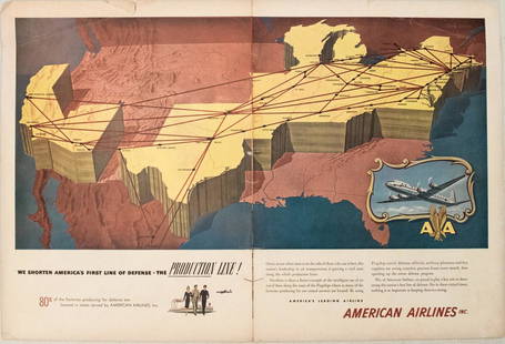
Sold20231950s American Airlines Route Map -- American Airlines Route MapTitle: 1950s American Airlines Route Map -- American Airlines Route Map Cartographer: American Airlines Year / Place: 1950s Map Dimension (in.): 12.5 X 19.2 in. joined This nice, large pictorial routeSee Sold Price
Sold2017Mercator (Gerard) - Atlas sive Cosmographicae,Editio Quinta, engraved pictorial title, prelims, 49 double-page maps, including Asia, Russia, Turkey, Lithuania, Asia Minor and Persia, regions of Italy Spain, Germany and Eastern Europe, and 11 singSee Sold Price
Sold2022(PICTORIAL MAPS.) John Diakoff; G. Primakoff; and P. Sergeeff. Map of China.(PICTORIAL MAPS.) John Diakoff; G. Primakoff; and P. Sergeeff. Map of China. Enormous chromolithographed map of China with profuse pictorial illustration, inset charts, reference tables, and scenic viSee Sold Price
Sold2022(PICTORIAL MAPS.) Ignatz Sahula. Map of the 18th Annual Convention of the National Association of(PICTORIAL MAPS.) Ignatz Sahula. Map of the 18th Annual Convention of the National Association of Real Estate Boards. City of Detroit - June 23 to June 26 1925. Detroit is Yours Realtors! Large color-See Sold Price
Sold2023A Decorative Pictorial Map of The New York Worlds Fair by William L. Longyear (American, 1899-1980)A Decorative Pictorial Map of The New York Worlds Fair by William L. Longyear (American, 1899-1980). Framed. Designed and copyrighted by William Longyear. Lithographed in U.S.A by Polygraphic CompanySee Sold Price
Sold2021Pictorial Map of Nantucket by Austin StrongHand colored in original and great condition, professionally matted and framed, c. 1921, 14 H inches x 17 W inches sight, 23 H inches x 26 W inches, overall. Austin Strong (1881-1952)Austin Strong, stSee Sold Price
Sold2020Pictorial map of Dude Ranches of the WestHeading: (Sportsman's...) Author: Blakeman, T.G. Title: The Sportsman's Dude Ranch Map Place Published: Boston Publisher:The Sportsman Publishing Co. Date Published: 1934 Description: <See Sold Price
Sold2020Color pictorial map of Panama Mail Steam Ship routeHeading: (Panama Mail Steamship - color pictorial map) Author: Godwin, Harrison Title: The sea coastes of America shewing the ports of call of the Panama Mail Steamships as the country there aboutes iSee Sold Price
Sold2020Rare pictorial map of Peking 1936Heading: (China - Beijing) Author: Dorn, Frank Title: A Map and History of Peiping, formerly known as Peking... Place Published: Tienstsin-Peiping Publisher:Peiyang Press, Ltd. Date Published: </See Sold Price
Sold2022(PICTORIAL MAPS.) Charles Turzak & Henry Chapman. An Illustrated Map of Chicago • Youthful(PICTORIAL MAPS.) Charles Turzak & Henry Chapman. An Illustrated Map of Chicago • Youthful City of the Big Shoulders • Restless • Ingenious • Wilful • Violent • ProSee Sold Price
Sold2022Marvelous pictorial map of the WorldHeading: (Maps) Author: Ensign & Thayer Title: World at One View Place Published: New York Publisher: Date Published: 1847 Description: Lithographed double-hemisphere map of theSee Sold Price
Sold2021Maurice Logan (1886-1977) Lake Tahoe Region / SouthernSpindle holes, water damage, tears and piece missing at top. 16" x 23".See Sold Price
May 16Potter & Potter AuctionsLINDGREN, Hjalmer “Jolly” (1895–1952). A Hysterical Map of ...$150(1 bid)
May 16Potter & Potter AuctionsLINDGREN, Jolly (1895-1952). A Hysterical Map of Yellowstone Park and the Jackson Hole Country$125
May 16Potter & Potter AuctionsHANDY, R.D. (1879 – 1959). Paul Bunyan’s Pictorial Map of t...$200
4 days LeftJasper521934 Greyhound Pictorial Map of the US -- A Good Natured Map of the United States Setting Forth the$140
May 16Potter & Potter Auctions[NEW YORK CITY – PICTORIAL MAPS]. Group of 3 pictorial maps...$200(1 bid)
May 16Potter & Potter Auctions[PICTORIAL MAPS – TRAVEL]. Three Pictorial Maps. 1940s/50s....$150
5 days LeftJasper52Cambridge "This immense & glorious work…" pictorial map by Kerry Lee 1948$440
5 days LeftJasper52Stratford-upon-Avon & William Shakespeare's life. Kerry Lee pictorial map c1965$440


![[NATIONAL PARKS] LINDGREN, Jolly (1895-1952). A Hysterical ...: [NATIONAL PARKS] LINDGREN, Jolly (1895-1952). A Hysterical Map of Yellowstone Park and the Jackson Hole Country Slightly Cockeyed. Circa 1950s. Colorful and comical pictorial map of Yellowstone Nation](https://p1.liveauctioneers.com/928/305275/163151881_1_x.jpg?height=310&quality=70&version=1697054833)

![[Map] Eddy, Gerald A. The Old Spanish and Mexican: [Map] Eddy, Gerald A. The Old Spanish and Mexican Ranchos of Los Angeles County. Los Angeles: Title Insurance and Trust Company, 1937. A pictorial map of the of the Los Angeles region in the 18th cent](https://p1.liveauctioneers.com/928/157910/79699338_1_x.jpg?height=310&quality=70&version=1577116583)


![[NEW YORK CITY – PICTORIAL MAPS]. Group of 3 pictorial maps... (1 of 3)](https://p1.liveauctioneers.com/928/325952/175495562_1_x.jpg?height=282&quality=70&version=1712935174)

![[PICTORIAL MAPS – TRAVEL]. Three Pictorial Maps. 1940s/50s.... (1 of 4)](https://p1.liveauctioneers.com/928/325952/175495561_1_x.jpg?height=282&quality=70&version=1712935174)


